- My Forums
- Tiger Rant
- LSU Recruiting
- SEC Rant
- Saints Talk
- Pelicans Talk
- More Sports Board
- Coaching Changes
- Fantasy Sports
- Golf Board
- Soccer Board
- O-T Lounge
- Tech Board
- Home/Garden Board
- Outdoor Board
- Health/Fitness Board
- Movie/TV Board
- Book Board
- Music Board
- Political Talk
- Money Talk
- Fark Board
- Gaming Board
- Travel Board
- Food/Drink Board
- Ticket Exchange
- TD Help Board
Customize My Forums- View All Forums
- Show Left Links
- Topic Sort Options
- Trending Topics
- Recent Topics
- Active Topics
Started By
Message
 2
2

Posted on 5/2/21 at 10:10 pm to rt3
met just told his co-worker to call his wife and make sure the sitter knows 
Posted on 5/2/21 at 10:14 pm to rt3
I haven’t really been keeping up but I couldn’t believe when I saw that warning on RadarScope earlier when I just happened to glance at it. Hour or two later I look and it’s still there I was floored. Then I looked at the velocity
I’m shocked, I live in Counce TN and all we have had is steady rain, no wind or a single clap of Thunder
I’m shocked, I live in Counce TN and all we have had is steady rain, no wind or a single clap of Thunder

Posted on 5/2/21 at 10:14 pm to rt3


Posted on 5/2/21 at 10:14 pm to Wishnitwas1998
Tornado Warning
MSC057-081-117-141-030345-
/O.NEW.KMEG.TO.W.0045.210503T0253Z-210503T0345Z/
BULLETIN - EAS ACTIVATION REQUESTED
Tornado Warning
National Weather Service Memphis TN
953 PM CDT Sun May 2 2021
...TORNADO EMERGENCY FOR TUPELO...
The National Weather Service in Memphis has issued a
* Tornado Warning for...
Northwestern Itawamba County in northeastern Mississippi...
Central Lee County in northeastern Mississippi...
Southern Tishomingo County in northeastern Mississippi...
Southeastern Prentiss County in northeastern Mississippi...
* Until 1045 PM CDT.
* At 952 PM CDT, a confirmed large and destructive tornado was
observed over Tupelo, moving northeast at 45 mph.
TORNADO EMERGENCY for Tupelo. This is a PARTICULARLY DANGEROUS
SITUATION. TAKE COVER NOW!
HAZARD...Deadly tornado.
SOURCE...Radar confirmed tornado.
IMPACT...You are in a life-threatening situation. Flying debris
may be deadly to those caught without shelter. Mobile
homes will be destroyed. Considerable damage to homes,
businesses, and vehicles is likely and complete
destruction is possible.
* Locations impacted include...
Tupelo, Baldwyn, Verona, Tombigbee State Park, Tishomingo State
Park, Saltillo, Guntown, Belmont, Plantersville, Mantachie,
Tishomingo, Burton, Pratts Friendship, Sandy Springs, Marietta,
Golden, Paden, Thrasher, Dennis and Mooreville.
People attending Tupelo COVID-19 Testing should seek safe shelter
immediately!
PRECAUTIONARY/PREPAREDNESS ACTIONS...
To repeat, a large, extremely dangerous and potentially deadly
tornado is on the ground. To protect your life, TAKE COVER NOW! Move
to an interior room on the lowest floor of a sturdy building. Avoid
windows. If in a mobile home, a vehicle or outdoors, move to the
closest substantial shelter and protect yourself from flying debris.
&&
LAT...LON 3450 8815 3415 8873 3425 8883 3434 8882
3474 8831 3457 8814
TIME...MOT...LOC 0252Z 230DEG 37KT 3428 8873
TORNADO...OBSERVED
TORNADO DAMAGE THREAT...CATASTROPHIC
HAIL...0.00IN

Posted on 5/2/21 at 10:16 pm to Pisco
That tornado had a debris ball for a bit

Posted on 5/2/21 at 10:16 pm to Wishnitwas1998
Looks like it lifted, but the TDS and velocity couplet seem to be picking back up.
Posted on 5/2/21 at 10:17 pm to rt3
I want to remember from his coverage of a previous tornado that he is a grad from Mississippi State's weather school. Good for them, good for him.
Posted on 5/2/21 at 10:17 pm to Roll Tide Ravens
This is from one of the Tupelo traffic cams before the power went out. From @darrobbins on Twitter.
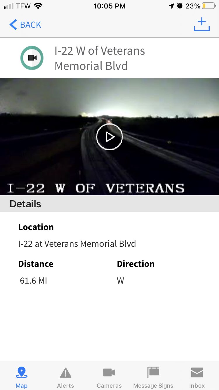
This post was edited on 5/2/21 at 10:18 pm
Posted on 5/2/21 at 10:17 pm to Roll Tide Ravens
This post was edited on 5/2/21 at 10:18 pm
Posted on 5/2/21 at 10:19 pm to Roll Tide Ravens
Tupelo was smoked by an EF-5 tornado in 1936
Posted on 5/2/21 at 10:19 pm to Bobby OG Johnson
tornado siren still going off in the background of the WTVA coverage
Posted on 5/2/21 at 10:21 pm to rt3
quote:
tornado siren still going off in the background of the WTVA coverage
Definitely adds to the intensity of the coverage
Posted on 5/2/21 at 10:23 pm to rt3
residential damage near the Elvis Presley Museum
Posted on 5/2/21 at 10:23 pm to Bobby OG Johnson
quote:
Definitely adds to the intensity of the coverage
Makes me feel like I’m there. It’s like hearing a tornado siren while watching Spann here in the Birmingham area.
Posted on 5/2/21 at 10:23 pm to Bobby OG Johnson
Elvis’s house was spared in 1936 but this one might have gone right through it
Posted on 5/2/21 at 10:24 pm to Roll Tide Ravens
Tupelo met talking about where the damage report is located and where the radar image was and immediately realized it didn't exactly match up

Posted on 5/2/21 at 10:24 pm to Bobby OG Johnson
quote:
Definitely adds to the intensity of the coverage


This post was edited on 5/2/21 at 10:26 pm
Posted on 5/2/21 at 10:25 pm to rt3

Posted on 5/2/21 at 10:28 pm to rt3
quote:
Tupelo met talking about where the damage report is located and where the radar image was and immediately realized it didn't exactly match up
That's the double-edged sword aspect of tracking at the street level via radar. He has said it multiple times, radar isn't perfect. I hope any person anywhere who finds themselves in the path of a tornadic storm remembers that. It can lead to a very false sense of security.

 Page 12 of 14

Popular
Back to top