- My Forums
- Tiger Rant
- LSU Recruiting
- SEC Rant
- Saints Talk
- Pelicans Talk
- More Sports Board
- Coaching Changes
- Fantasy Sports
- Golf Board
- Soccer Board
- O-T Lounge
- Tech Board
- Home/Garden Board
- Outdoor Board
- Health/Fitness Board
- Movie/TV Board
- Book Board
- Music Board
- Political Talk
- Money Talk
- Fark Board
- Gaming Board
- Travel Board
- Food/Drink Board
- Ticket Exchange
- TD Help Board
Customize My Forums- View All Forums
- Show Left Links
- Topic Sort Options
- Trending Topics
- Recent Topics
- Active Topics
Started By
Message
re: Storm Aftermath - Hurricane Matthew will be Retired
Posted on 10/2/16 at 4:31 pm to NorthEndZone

Posted on 10/2/16 at 4:31 pm to NorthEndZone
 1
1

Posted on 10/2/16 at 4:43 pm to PsychTiger
quote:
UKMI can suck a dick
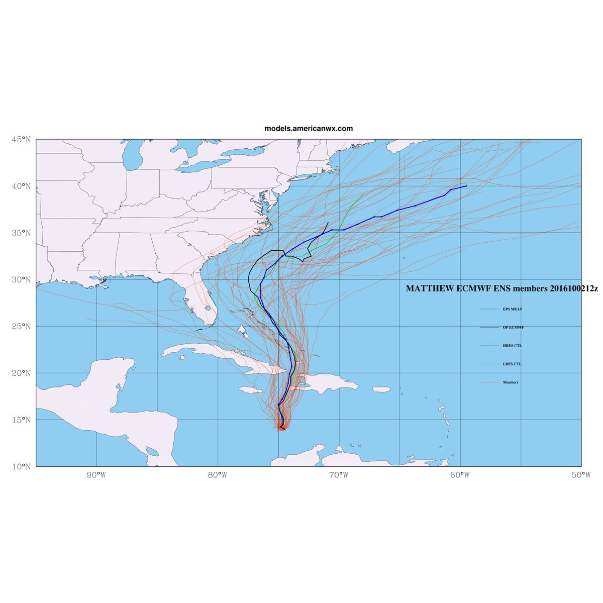
The UK was one of the best performing models for Hermine but it is traditional about on par with the GFS. The 12z Euro was basically the same as 00z. The spread on the Euro EPS bumped back to the west at 12z with about 20% of the members getting into Florida/Gulf:
From Allen Huffman (@RaleighWx)
Posted on 10/2/16 at 4:47 pm to 10MTNTiger
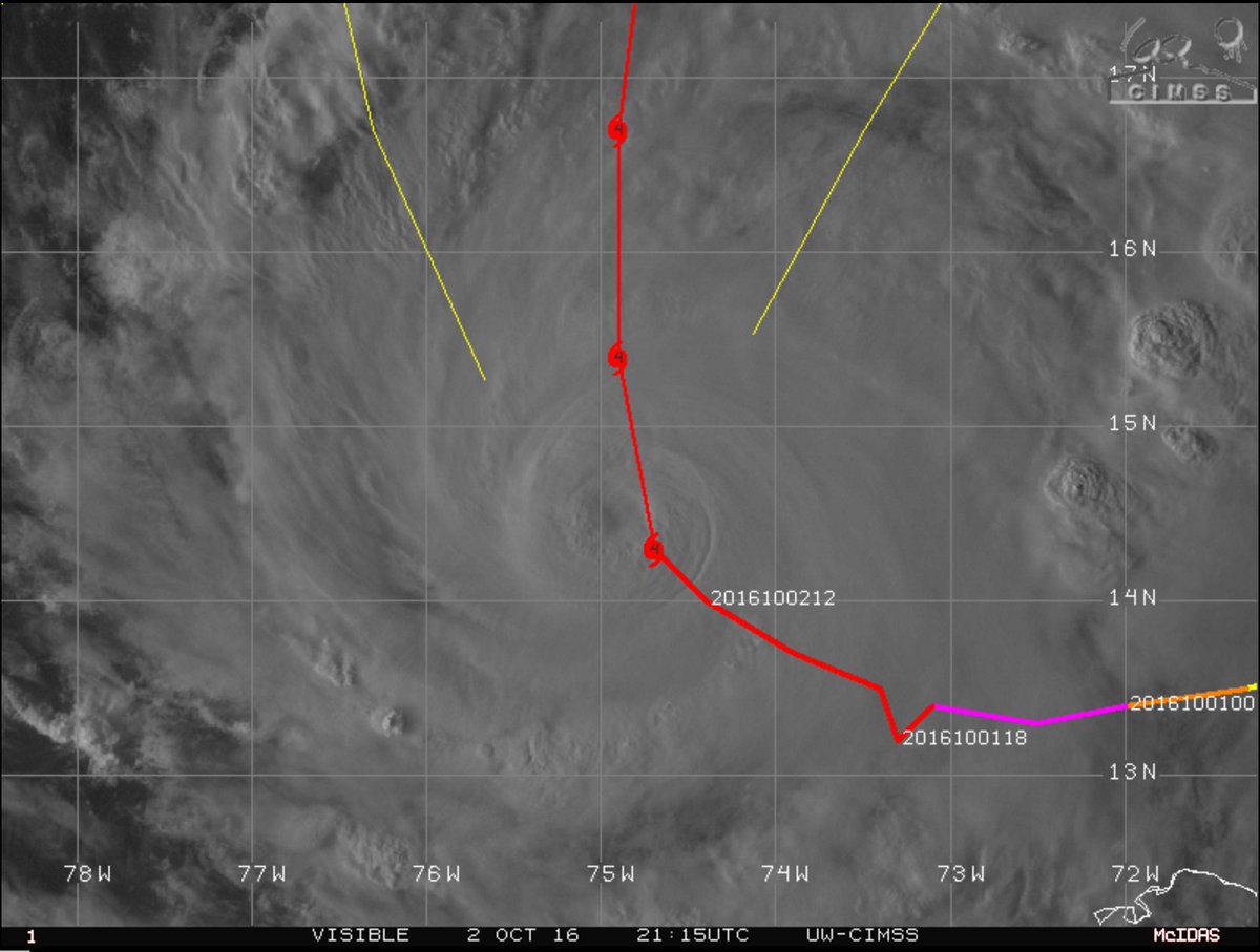
The main thing you need to keep an eye on in GTMO is the longitude of the center. If it tracks due north from where it currently is at 74.9W, GTMO at 75.1 / 75.2W would get the western eyewall.
The NHC has Matthew bending back east a little before making landfall. IF it tracks farther west than currently forecast AND/OR doesn't bend back to the east as currently forecast, then GTMO would get the western eye-wall which would make a huge difference in the conditions there - especially on the eastern end of the base.

The NHC has Matthew bending back east a little before making landfall. IF it tracks farther west than currently forecast AND/OR doesn't bend back to the east as currently forecast, then GTMO would get the western eye-wall which would make a huge difference in the conditions there - especially on the eastern end of the base.
This post was edited on 10/2/16 at 5:07 pm
Posted on 10/2/16 at 4:47 pm to VABuckeye
quote:
Turks & Caicos is flat. They could be in trouble there.
yup storm surge could swamp the entire island chain.
the highest point in TCI is only 150 ft. tall
Posted on 10/2/16 at 5:10 pm to NorthEndZone
Thanks I really appreciate that. I will keep a look out for the turns now...Im guessing by this time tomorrow we will probably know what will be the deal

Posted on 10/2/16 at 5:37 pm to rds dc
Looks like a significant westward component of motion still exists. It may be going a little left (west) of the NHC forecast - at least for now.
Posted on 10/2/16 at 5:49 pm to NorthEndZone
quote:
Looks like a significant westward component of motion still exists. It may be going a little left (west) of the NHC forecast - at least for now.
Ultimately, I won't make any difference but it is fun to watch how erratic these things can be in the short term. It will eventually turn N or NE, even the UK that eventually sends it to Miami turns it back NE to Haiti.
This post was edited on 10/2/16 at 5:53 pm
Posted on 10/2/16 at 6:07 pm to rds dc
Yeah. It's a long way from any land and still has time to split the uprights and avoid populated areas. With the compact wind field and slow movement, rainfall will possibly and hopefully be the biggest problem for populated areas.

Posted on 10/2/16 at 6:48 pm to NorthEndZone

Posted on 10/2/16 at 7:52 pm to cajunangelle
that's two days old now.
Posted on 10/2/16 at 8:51 pm to rds dc
Posted on 10/2/16 at 9:19 pm to ZULU
Buoy about 20 miles north of center. Should get in eye in next couple of hours.

Posted on 10/2/16 at 10:03 pm to rds dc
Not often you see such a persistent convective pattern like this with a hurricane. Seems more like something from the Pacific than the Atlantic.
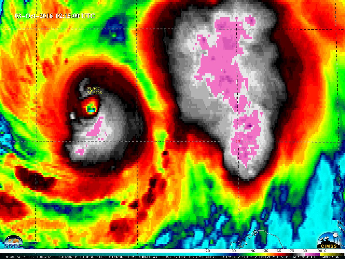

Posted on 10/2/16 at 10:27 pm to rds dc
That is one nasty blob.

Posted on 10/2/16 at 10:58 pm to rds dc
For such a powerful storm, thankfully it doesn't appear to be massive in size. I remember Katrina looked like it filled the entire GOM at one point.
Posted on 10/2/16 at 11:00 pm to rds dc
Matthew has been an intriguing storm to say the least
Posted on 10/2/16 at 11:37 pm to lsuman25
Tonight's GFS is back to tracking very close to the outer banks.


Posted on 10/3/16 at 6:20 am to NorthEndZone
Neat to see the eye like that , thanks for posting

 Page 34 of 181

Popular
Back to top