- My Forums
- Tiger Rant
- LSU Recruiting
- SEC Rant
- Saints Talk
- Pelicans Talk
- More Sports Board
- Fantasy Sports
- Golf Board
- Soccer Board
- O-T Lounge
- Tech Board
- Home/Garden Board
- Outdoor Board
- Health/Fitness Board
- Movie/TV Board
- Book Board
- Music Board
- Political Talk
- Money Talk
- Fark Board
- Gaming Board
- Travel Board
- Food/Drink Board
- Ticket Exchange
- TD Help Board
Customize My Forums- View All Forums
- Show Left Links
- Topic Sort Options
- Trending Topics
- Recent Topics
- Active Topics
Started By
Message
re: Storm Aftermath - Hurricane Matthew will be Retired
Posted on 9/30/16 at 10:10 pm to GeorgeTheGreek
Posted on 9/30/16 at 10:10 pm to GeorgeTheGreek
quote:
Why are you screaming?
I assume he copied and pasted the advisory.
 2
2


Posted on 9/30/16 at 10:12 pm to Bestbank Tiger
yeah, they're published in all caps on the NHC website.
meteorologists love caps lock
meteorologists love caps lock
Posted on 9/30/16 at 10:13 pm to Bestbank Tiger
quote:
I assume he copied and pasted the advisory.
Yep that's what I did. Your friend needs to chill.
This post was edited on 9/30/16 at 10:13 pm
Posted on 9/30/16 at 10:14 pm to Roll Tide Ravens
From exposed LLC yesterday

to Cat 5 monster tonight
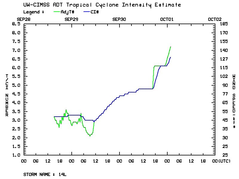
to Cat 5 monster tonight

Posted on 9/30/16 at 10:16 pm to rds dc
Crazy...

Posted on 9/30/16 at 10:20 pm to RummelTiger
Rummy can you edit thread title to "tracting"?
Thanks
And wasnt there a hurricane last year that went from trop storm to 200 mph in 24 hours?
Thanks
And wasnt there a hurricane last year that went from trop storm to 200 mph in 24 hours?
Posted on 9/30/16 at 10:22 pm to Cosmo
yeah, Patricia was pretty insane.
LINK
quote:
The magnitude of Patricia's rapid intensification is among the fastest ever observed. In a 24-hour period, 06:00–06:00 UTC October 22–23, its maximum sustained winds increased from 85 mph (140 km/h) to 205 mph (335 km/h), a record increase of 120 mph (195 km/h). During the same period, Patricia's central pressure fell by 95 mbar (hPa; 2.81 inHg). Despite record over-water weakening prior to striking Mexico, Patricia became the most intense Pacific hurricane to make landfall, with a pressure of 932 mbar (hPa; 27.52 inHg
LINK
Posted on 9/30/16 at 10:30 pm to baytiger
Patricia
Tip
Wilma
The greatest storms in recorded history all reached their peak within a week of my Birthday.
When is my Birthday?
Tip
Wilma
The greatest storms in recorded history all reached their peak within a week of my Birthday.
When is my Birthday?
This post was edited on 9/30/16 at 10:39 pm
Posted on 9/30/16 at 10:36 pm to baytiger
00z GFS was initialized with more ridging over the top than what 18z was showing at 00z. Who knows if it will have an longer term track implications but the ridge isn't breaking down as fast as the models want it.
00z

vs. 18z at 00z

00z
vs. 18z at 00z
Posted on 9/30/16 at 10:46 pm to rds dc
quote:
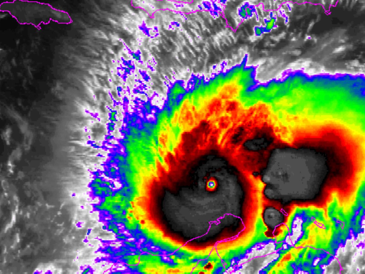
Philip Klotzbach ?@philklotzbach 26m26 minutes ago Walnut Creek, CA #Matthew is the lowest latitude category 5 hurricane in the Atlantic on record at 13.3°N (prior record Felix (2007) at 13.7°N).


Posted on 9/30/16 at 10:47 pm to rds dc
Poor Jamaica

Posted on 9/30/16 at 11:00 pm to rds dc
Oh wow cat 5? I am very coastal NC. Are the models updated?
Posted on 9/30/16 at 11:01 pm to SG_Geaux
I wonder if The Weather Channel will have a reporter on the ground in Jamaica for this.
Posted on 9/30/16 at 11:03 pm to cajunangelle
quote:
Oh wow cat 5? I am very coastal NC. Are the models updated?
00z Early track models are out (below), the GFS is running and the Euro will run later tonight.

Posted on 9/30/16 at 11:04 pm to TigersHuskers
Just tried weather channel and they are dicking around with some why airplanes crash show...
Isn't their main attraction hurricanes?
Isn't their main attraction hurricanes?
Posted on 9/30/16 at 11:04 pm to TigersHuskers
looks like the 0z GFS takes it over the eastern tip of Jamaica. It is a tad bit west of where the 18z GFS had it. Then it goes over eastern Cuba. Not sure how much it weakens over Cuba, I dont think it goes below a Cat 2 since that part isnt the real mountainous part of it compared to the rest of Cuba and other Islands down there. It is also traveling over the short part, not longways. Shorter time over land. Also I wonder how much it blows up over the Bahamas.
This post was edited on 9/30/16 at 11:07 pm
Posted on 9/30/16 at 11:09 pm to atchafalaya
quote:
Isn't their main attraction hurricanes?
If this hits the northeast its gonna be nonstop.
only the urban areas though. I went through Irene and upstate NY, VT, and western MA got zero news coverage of the 500 year floods there, instead all the media worried about was the high tide being 5 feet ablve normal in NYC. Oh well.
This post was edited on 9/30/16 at 11:10 pm
Posted on 9/30/16 at 11:10 pm to rds dc
So, if the center goes W of 75W when it goes N of 15N in the next 24 - 48 hours, we throw out these tracks and get Florida bracing for impact?
Posted on 9/30/16 at 11:12 pm to East Coast Band
0z GFS at 120 hours

This post was edited on 9/30/16 at 11:13 pm
Posted on 9/30/16 at 11:13 pm to TigersHuskers
quote:
looks like the 0z GFS takes it over the eastern tip of Jamaica. It is a tad bit west of where the 18z GFS had it. Then it goes over eastern Cuba. Not sure how much it weakens over Cuba, I dont think it goes below a Cat 2 since that part isnt the real mountainous part of it compared to the rest of Cuba and other Islands down there. It is also traveling over the short part, not longways. Shorter time over land. Also I wonder how much it blows up over the Bahamas
Slightly SW of 18z at 114hrs with the ridge building over the top, main energy with the Western trough is already lifting out towards Canada.

 Page 23 of 181

Popular
Back to top