- My Forums
- Tiger Rant
- LSU Recruiting
- SEC Rant
- Saints Talk
- Pelicans Talk
- More Sports Board
- Fantasy Sports
- Golf Board
- Soccer Board
- O-T Lounge
- Tech Board
- Home/Garden Board
- Outdoor Board
- Health/Fitness Board
- Movie/TV Board
- Book Board
- Music Board
- Political Talk
- Money Talk
- Fark Board
- Gaming Board
- Travel Board
- Food/Drink Board
- Ticket Exchange
- TD Help Board
Customize My Forums- View All Forums
- Show Left Links
- Topic Sort Options
- Trending Topics
- Recent Topics
- Active Topics
Started By
Message
re: Storm Aftermath - Hurricane Matthew will be Retired
Posted on 10/5/16 at 6:52 pm to LakeViewLSU
Posted on 10/5/16 at 6:52 pm to LakeViewLSU
quote:
Nobody is looking at who upvotes or downvotes
Rummy mentioned he didn't understand why he got the down votes for a suggestion he made yesterday evening in this thread. I've always assumed the admins could see, so I wondered why he didn't ask those posters directly. I asked him and eventually asked ByteMe who said that they couldn't see.
 4
4

Posted on 10/5/16 at 6:55 pm to slackster
Matthew down to 115mph winds but expected to intensify tonight and tomorrow
Posted on 10/5/16 at 6:55 pm to slackster
NAVGEM isn't promising for LSU/UF on Saturday...

Posted on 10/5/16 at 6:55 pm to slackster
quote:
Meanwhile, Nicole has about as much gumption and direction as a 22 year old sophomore art majo
The Fujiwara effect is latest fad these days.

Posted on 10/5/16 at 6:58 pm to slackster

Posted on 10/5/16 at 7:01 pm to lsuman25
quote:
Matthew down to 115mph winds but expected to intensify tonight and tomorrow
I can believe it. It essentially had to tear itself down a bit in order to get its act together later.
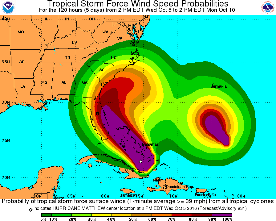
From the NHC 8PM EDT Advisory:
quote:
At 800 PM EDT (0000 UTC), the eye of Hurricane Matthew was located
near latitude 23.0 North, longitude 76.0 West. Matthew is moving
toward the northwest near 12 mph (19 km/h), and this motion is
expected to continue during the next 24 to 48 hours. On this track,
Matthew will be moving across the Bahamas tonight and tomorrow, and
is expected to be very near the east coast of Florida by tomorrow
night.
Reports from NOAA and Air Force Reserve Hurricane Hunter aircraft
indicate that maximum sustained winds have decreased to near 115
mph (185 km/h) with higher gusts. Matthew is a category 3 hurricane
on the Saffir-Simpson Hurricane Wind Scale. The recent weakening
is likely to be short-lived, as Matthew as expected to intensify
later tonight and Thursday. The hurricane is expected to remain at
a category 3 or stronger intensity while it moves through the
Bahamas and approaches the east coast of Florida.
Hurricane-force winds extend outward up to 45 miles (75 km) from
the center and tropical-storm-force winds extend outward up to 175
miles (280 km).
The minimum central pressure reported by the Hurricane Hunter
aircraft is 962 mb (28.41 inches).
Posted on 10/5/16 at 7:01 pm to lsuman25
Once Matthew can establish a better outflow channel to the north and close off the SW side of the eye wall, should start to see it take off.

Posted on 10/5/16 at 7:03 pm to slackster
quote:
Meanwhile, Nicole has about as much gumption and direction as a 22 year old sophomore art major:
She's waiting on Matthew to loop around and meet her.
This post was edited on 10/5/16 at 7:09 pm
Posted on 10/5/16 at 7:03 pm to Duke
Looks like the NHC is fully on board with it looping back south 

Posted on 10/5/16 at 7:04 pm to ForeverLSU02
Big cone of error though. There's a lot of disagreement between the euro and the GFS models that far out.
Posted on 10/5/16 at 7:07 pm to bluemoons
remember cones don't shift at intermediate advisories.
Posted on 10/5/16 at 7:07 pm to slackster
Hugo is the only one who can see upvotes and downvotes. While Chicken wouldn't make him a full Admin, he gave him that.

Posted on 10/5/16 at 7:07 pm to slackster
The Bahamas are flat. There. Is nothing to stop this storm from getting more powerful.
Posted on 10/5/16 at 7:11 pm to lsuman25
quote:
remember cones don't shift at intermediate advisories.
Gotcha. How often do the cones shift?
This has been a really educational thread for me. Interesting stuff.
Posted on 10/5/16 at 7:12 pm to bluemoons
10pm 4am 10am 4pm
Posted on 10/5/16 at 7:14 pm to bluemoons
yea you definitely learn things in a thread like this.

Posted on 10/5/16 at 7:14 pm to dukke v
quote:
The Bahamas are flat. There. Is nothing to stop this storm from getting more powerful.
They are land. Land reduceses' 'canes.
Posted on 10/5/16 at 7:21 pm to Duke

Using the NHC's forecast advisory from the 5 PM EDT update, this is where Matthew is forecast to be at 4PM EDT on Friday. The line to the NW and the data points along it represent the expected extent of 64 kt (74 mph) winds, 50 kt (58 mph) winds, and lastly 34 kt (39 mph) winds.
This is based on the expected extent of the winds in the NW quadrant.
Posted on 10/5/16 at 7:22 pm to dukke v
Chicken told you to stay out of threads where people rely on accurate, life saving information

 Page 103 of 181

Popular
Back to top