- My Forums
- Tiger Rant
- LSU Recruiting
- SEC Rant
- Saints Talk
- Pelicans Talk
- More Sports Board
- Coaching Changes
- Fantasy Sports
- Golf Board
- Soccer Board
- O-T Lounge
- Tech Board
- Home/Garden Board
- Outdoor Board
- Health/Fitness Board
- Movie/TV Board
- Book Board
- Music Board
- Political Talk
- Money Talk
- Fark Board
- Gaming Board
- Travel Board
- Food/Drink Board
- Ticket Exchange
- TD Help Board
Customize My Forums- View All Forums
- Show Left Links
- Topic Sort Options
- Trending Topics
- Recent Topics
- Active Topics
Started By
Message
re: Southeast Severe Weather: 12/28 - 12/29
Posted on 12/28/24 at 8:53 pm to Wishnitwas1998

Posted on 12/28/24 at 8:53 pm to Wishnitwas1998
I just went through a patch in Ponchatoula / Hammond Louisiana around 7:30-7:45 that was incredible. Everyone on 1-12 pulled over or drove 10-15 mph for about ten minutes. It had to be a supercell with everything blowing sideways including small tree branches . The rain was intense. When I got to Baton Rouge there was a huge full size tree blocking the Millerville exit. I have to say I was impressed with people being cautious. I did not see “ that guy”.
Feeling dread for those of you in Mississippi, Alabama, Georgia etc. Stay safe .
Feeling dread for those of you in Mississippi, Alabama, Georgia etc. Stay safe .
 2
2


Posted on 12/28/24 at 8:54 pm to Wishnitwas1998
James Spann on now on the ABC 33/40 YouTube live
LINK
LINK
Posted on 12/28/24 at 8:55 pm to Lsupimp
Praying y'all did not get any damage

Posted on 12/28/24 at 8:56 pm to geauxtigers87
quote:
this may be one of the more interesting things i've ever read in one of these weather threads but it makes perfect sense. never considered different offices doing different things like that. always just think of NWS as NWS
NWS Birmingham has worked hard over the last 10-12 years to reduce its false alarm ration (issuing tornado warnings where nothing ever happens). I think tonight they will issue severe thunderstorm warnings with a “tornado possible” tag and save the tornado warnings for when there is decent evidence that a tornado may occur or is occurring.
Posted on 12/28/24 at 8:57 pm to Roll Tide Ravens
quote:
We’re going to see the difference in philosophy between NWS offices for squall line tornadoes when this thing crosses the state line. NWS Jackson has been blanket issuing tornado warnings for the squall line. NWS Birmingham doesn’t typically do that. They issue tornado warnings only when something truly warrants a warning.
Memphis is the same way. It is crazy the number of warnings that don't get carried over by Huntsville.
This post was edited on 12/28/24 at 8:58 pm

Posted on 12/28/24 at 8:57 pm to Wishnitwas1998
quote:
Appreciate the espanol Bobby
The least I could do
Thracken13
Posted on 12/28/24 at 8:58 pm to Roll Tide Ravens
quote:Spann just confirmed what you posted earlier. NWS Birmingham isn't going to blanket warnings like Jackson. Good call.
Roll Tide Ravens
Posted on 12/28/24 at 8:59 pm to Bobby OG Johnson
No hablo español
Posted on 12/28/24 at 8:59 pm to Roll Tide Ravens
And on cue, NWS Birmingham has issued severe thunderstorm warnings instead of tornado warnings for its first row of counties in west Alabama.
Posted on 12/28/24 at 9:01 pm to Roll Tide Ravens
Yup. Pickens, Greene and Sumter counties
Posted on 12/28/24 at 9:01 pm to biggsc
James calling out mobile homes in his nice way as he always does 

Posted on 12/28/24 at 9:01 pm to Roll Tide Ravens
In Metairie a noticeable drop in temp.. Starting to rain with thunder and lightening..
Posted on 12/28/24 at 9:03 pm to Athis
Tornado Warning Pickens County in AL
Posted on 12/28/24 at 9:03 pm to biggsc
quote:
James Spann on now on the ABC 33/40 YouTube live
Jacket is off
Posted on 12/28/24 at 9:05 pm to Thracken13
quote:I live in west Tuscaloosa County not far from the Pickens County line. I'll let yall know lol
Tornado Warning Pickens County in AL
Posted on 12/28/24 at 9:05 pm to Thracken13
disregard - i pulled up his page and it started running a stream from 2 years ago.
This post was edited on 12/28/24 at 9:07 pm
Posted on 12/28/24 at 9:05 pm to Roll Tide Ravens
quote:
NWS Birmingham has worked hard over the last 10-12 years to reduce its false alarm ration (issuing tornado warnings where nothing ever happens). I think tonight they will issue severe thunderstorm warnings with a “tornado possible” tag and save the tornado warnings for when there is decent evidence that a tornado may occur or is occurring.
Which is absolutely the correct move going forward for all NWS offices to try to keep people from
Ignoring warnings
Next on the list is reducing the staggering amount of Severe thunderstorms warnings that don't verify but one thing at a time
Posted on 12/28/24 at 9:07 pm to mikeboss550
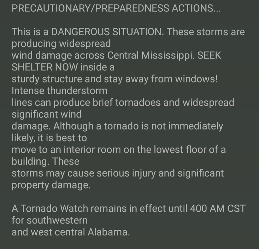
Basically one large Severe Thunderstorm Warning with a tornado possible tag.
Posted on 12/28/24 at 9:08 pm to Wishnitwas1998

Posted on 12/28/24 at 9:14 pm to Bobby OG Johnson


 Page 21 of 26

Popular
Back to top