- My Forums
- Tiger Rant
- LSU Recruiting
- SEC Rant
- Saints Talk
- Pelicans Talk
- More Sports Board
- Fantasy Sports
- Golf Board
- Soccer Board
- O-T Lounge
- Tech Board
- Home/Garden Board
- Outdoor Board
- Health/Fitness Board
- Movie/TV Board
- Book Board
- Music Board
- Political Talk
- Money Talk
- Fark Board
- Gaming Board
- Travel Board
- Food/Drink Board
- Ticket Exchange
- TD Help Board
Customize My Forums- View All Forums
- Show Left Links
- Topic Sort Options
- Trending Topics
- Recent Topics
- Active Topics
Started By
Message
re: Southeast Severe Weather: 12/28 - 12/29
Posted on 12/28/24 at 4:12 pm to LegendInMyMind

Posted on 12/28/24 at 4:12 pm to LegendInMyMind
quote:Any chance this thing impacts Lake Charles?
And our long tracker is back over water in the Sabine Lake now.
 1
1

Posted on 12/28/24 at 4:13 pm to red sox fan 13
quote:
Any chance this thing impacts Lake Charles?
Hell, I don't know. It hasn't slowed down yet. If it keeps going it would likely be south of LC.
Posted on 12/28/24 at 4:13 pm to The Levee
quote:
I’m in a deer stand in woodville MS. Should I go back to the camp? All we have here now is wind and no rain.
That all depends, I have been In Plenty of deer stands that are built far more sturdy than some of the camps I have stayed in
That being said I am currently in a nice box stand just north of Tylertown, keeping an eye on the radar , and am well prepared for a quick extraction if necessary
This post was edited on 12/28/24 at 4:18 pm

Posted on 12/28/24 at 4:14 pm to Tigerpaw123
The Brookhaven, MS tornado is no longer confirmed on the ground.
Posted on 12/28/24 at 4:16 pm to Roll Tide Ravens

The severe weather threat for Tornado Watch 720 continues.
SUMMARY...Isolated supercell development across southern MS and
southeastern LA could pose a significant tornado threat over the
coming hours. However, displaced east from the strongest synoptic
forcing, it remains unclear how persistent the threat may be until
later this evening.
DISCUSSION...Across the eastern edge of PDS Tornado Watch 720, an
isolated supercell (with recent reports of a tornado) was observed
over northeastern Franklin County MS. Additional discrete
development has been noted farther south into southeastern LA,
likely along a subtle confluence axis stretching into the northern
Gulf of Mexico. This storm has slowly organized over the last
several hours, coincident with the northward advection of a weak
warm front. An unstable air mass with 1000-1500 J/kg of MLCAPE and
strong low-level shear (300-400 m2/s2 ESRH JAN DGX VAD) is
supportive of a continued severe threat. The strong low-level shear
is also conditionally supportive of a strong and long-track tornado
threat into central MS given the favorable storm mode.
However, much of this activity is displaced farther east from the
stronger synoptic forcing until later this evening. This could tend
to make the threat somewhat intermittent until stronger forcing
arrives. Thus, while the environment is favorable for a continued,
and conditionally significant severe/tornado threat, there remains
some uncertainty on the duration/longevity of the risk.
..Lyons.. 12/28/2024

Posted on 12/28/24 at 4:18 pm to LegendInMyMind
quote:
. It hasn't slowed down yet. If it keeps going it would likely be south of LC.
Great.
Posted on 12/28/24 at 4:20 pm to Roll Tide Ravens
The long tracker is back over land for the time being with a weak TDS. So, it has crossed both the Galveston Bay and Sabine Lake and remained a tornado.
ETA: It now has a strong TDS.
ETA: It now has a strong TDS.
This post was edited on 12/28/24 at 4:21 pm
Posted on 12/28/24 at 4:21 pm to The Levee
quote:
I’m in a deer stand in woodville MS

Quick! Head to this place.
Posted on 12/28/24 at 4:25 pm to LSURoss
Posted on 12/28/24 at 4:27 pm to LegendInMyMind
If I was to the south of Lake Chuck I would start getting my plan for shelter together.
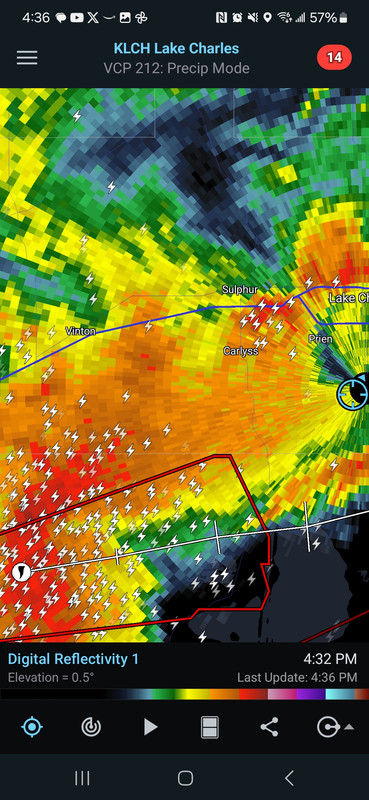
It will be south of the airport, or where the weather radar is located.
With all the water for it to cross over it may not show a strong tornado debris signature at times, but the circulation has remained impressive.
It will be south of the airport, or where the weather radar is located.
With all the water for it to cross over it may not show a strong tornado debris signature at times, but the circulation has remained impressive.
This post was edited on 12/28/24 at 4:31 pm
Posted on 12/28/24 at 4:31 pm to LegendInMyMind
quote:
It will be south of the airport, or where the weather radar is located.
Radar is at the airport. That warning box would put it south of the airport, right around the cal cam line.
Posted on 12/28/24 at 4:32 pm to Tigerfan1274
quote:
Radar is at the airport. That warning box would put it south of the airport, right around the cal cam line.
You all know more about the area than I do. I'd take this one seriously. Hopefully, it finally dies.
Posted on 12/28/24 at 4:32 pm to LegendInMyMind
quote:KLCL, which was destroyed in Hurricane Laura.
It will be south of the airport, or where the weather radar is located.
Posted on 12/28/24 at 4:35 pm to DoctorTechnical
Tornado warning pike county
Posted on 12/28/24 at 4:36 pm to LegendInMyMind
Right where I am. I can see the radar dome to the east from my front porch. Guess I'll let y'all know what happens here in about 30 minutes.
This post was edited on 12/28/24 at 4:37 pm

Posted on 12/28/24 at 4:37 pm to Tigerpaw123
This weather has had me glued to the radar all day. We are in BR having Christmas with our friends and I’ve been watching the storms in East Texas barrel toward Calcasieu hoping they miss us.
Posted on 12/28/24 at 4:38 pm to LSURoss
Good luck, baw! The rotation doesn't look as good as it has, but the storm still has good structure and clean inflow. Don't trust it.
Posted on 12/28/24 at 4:40 pm to LegendInMyMind
I’ve been a weather watcher for 40 years in the Acadiana area. I can’t recall a tornado staying on the ground as long as the one near the Sabine River
Posted on 12/28/24 at 4:44 pm to LSURoss
quote:
Right where I am. I can see the radar dome to the east from my front porch.
I’m about two miles north of you. Good luck!
Posted on 12/28/24 at 4:45 pm to purple18
quote:
I’ve been a weather watcher for 40 years in the Acadiana area. I can’t recall a tornado staying on the ground as long as the one near the Sabine River
It is unusual down that way, for sure. I bet it challenges records for the region. Tracking damage will be a problem, though, with all the water.

 Page 10 of 26

Popular
Back to top