- My Forums
- Tiger Rant
- LSU Recruiting
- SEC Rant
- Saints Talk
- Pelicans Talk
- More Sports Board
- Fantasy Sports
- Golf Board
- Soccer Board
- O-T Lounge
- Tech Board
- Home/Garden Board
- Outdoor Board
- Health/Fitness Board
- Movie/TV Board
- Book Board
- Music Board
- Political Talk
- Money Talk
- Fark Board
- Gaming Board
- Travel Board
- Food/Drink Board
- Ticket Exchange
- TD Help Board
Customize My Forums- View All Forums
- Show Left Links
- Topic Sort Options
- Trending Topics
- Recent Topics
- Active Topics
Started By
Message
re: Southeast and Midwest Severe Weather Outbreak & Flood Event: April 2-7, 2025
Posted on 4/3/25 at 1:46 pm to tigerbandpiccolo
Posted on 4/3/25 at 1:46 pm to tigerbandpiccolo
quote:
Chilly in WLR
That’s where I am, 430 and Cantrell.
 2
2

Posted on 4/3/25 at 1:55 pm to WhuckFistle
Can the weather leave Arkansas alone please? 

Posted on 4/3/25 at 1:57 pm to WhuckFistle
Find it interesting that the tires are gone while the wheels remain.

Posted on 4/3/25 at 2:12 pm to BuckyCheese
quote:
Find it interesting that the tires are gone while the wheels remain.
Give the maker of them lugnuts a raise

Posted on 4/3/25 at 2:15 pm to Roll Tide Ravens
Two tornado watches currently in effect this afternoon:

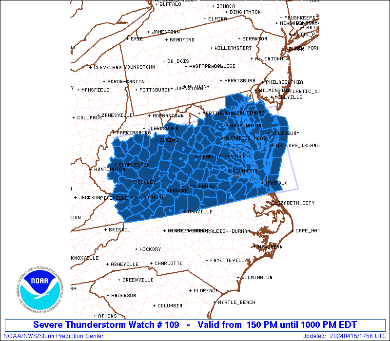
This post was edited on 4/3/25 at 2:16 pm
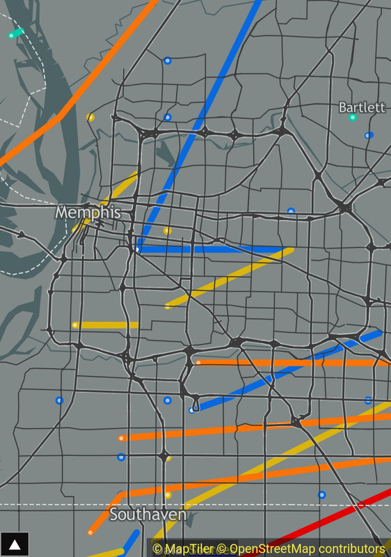
Posted on 4/3/25 at 2:19 pm to deltaland
quote:
All these warned cells looking at Memphis like
And they went home cucked.
Tornadoes don't touchdown inside I-240.

Posted on 4/3/25 at 2:44 pm to LegendInMyMind
quote:
There are also now three consecutive High Risk days (today-Saturday) for excessive rainfall across the area we've been watching.
NOAA has upped their crest predictions for the Ohio in Louisville proper. Was 30 feet, now up around 33.2. We start closing floodgates on the river here around 32 feet (2nd street is usually the first one on our side of the river, then Bingham Way). Anything over 38 feet is considered major flooding here. 55.2 is where water reaches the top of the Louisville flood walls. It will likely be a Top 15 historical cresting event for the Ohio.
Top 15 Historic Crests at the Ohio:
1. 52.15 ft on 01-27-1937
2. 42.10 ft on 03-08-1945
3. 41.70 ft on 02-16-1884
4. 41.20 ft on 03-12-1964
5. 39.50 ft on 02-16-1883
6. 39.40 ft on 04-02-1913
7. 38.76 ft on 03-07-1997
8. 36.40 ft on 01-22-1907
9. 36.00 ft on 04-19-1948
10. 35.72 ft on 02-26-2018
11. 34.10 ft on 03-23-1933
12. 33.40 ft on 03-04-1962
13. 33.00 ft on 05-10-1961
14. 33.00 ft on 03-23-1943
15. 32.40 ft on 02-22-1882
Ohio River at Upper McAlpine
This post was edited on 4/3/25 at 2:46 pm
Posted on 4/3/25 at 2:52 pm to AlonsoWDC
quote:
Tornadoes don't touchdown inside I-240.
Not a whole lot, but it does happen occasionally.
Posted on 4/3/25 at 2:56 pm to LegendInMyMind

Posted on 4/3/25 at 3:03 pm to rt3
quote:
Give the maker of them lugnuts a raise
The tornado clearly didn't have the anti-theft "key".
Posted on 4/3/25 at 3:10 pm to WhuckFistle
We probably know each other. 

Posted on 4/3/25 at 3:11 pm to LegendInMyMind
What’s the driving force behind this severe weather lasting multiple days in the same general area? Seems like usually the front comes through and you have a chance at severe weather for 4 or 5 hours then it’s done.
Posted on 4/3/25 at 3:15 pm to BOSCEAUX
quote:
What’s the driving force behind this severe weather lasting multiple days in the same general area? Seems like usually the front comes through and you have a chance at severe weather for 4 or 5 hours then it’s done.
The front stalled.
Posted on 4/3/25 at 3:17 pm to WhuckFistle
Lake City prelim EF3?
I figured mid to high EF4
Could still be once they can actually finish the survey I guess
I figured mid to high EF4
Could still be once they can actually finish the survey I guess
Posted on 4/3/25 at 3:19 pm to LegendInMyMind
thank Florida for parking a High Pressure over the state.
Posted on 4/3/25 at 3:20 pm to LegendInMyMind
quote:
The front stalled.
And I’m grateful for high pressure that is keeping Alabama out of this event, at least until late Saturday/Sunday.
Posted on 4/3/25 at 3:21 pm to tigerbandpiccolo
quote:
We probably know each other
Wouldn’t surprise me, I work at FIS.
Posted on 4/3/25 at 3:22 pm to WhuckFistle
I work for one of your competitors lol - but I'm in Alabama.
you guys be safe over there
you guys be safe over there
Posted on 4/3/25 at 3:31 pm to rt3
quote:
Lake City prelim EF3?
I figured mid to high EF4
Could still be once they can actually finish the survey I guess
We will see. It could get a bump to a 4, but I don't think it will be a high end 4.
Posted on 4/3/25 at 4:00 pm to Roll Tide Ravens
Storm south of Nashville, near Franklin.


 Page 23 of 38

Popular
Back to top