- My Forums
- Tiger Rant
- LSU Recruiting
- SEC Rant
- Saints Talk
- Pelicans Talk
- More Sports Board
- Fantasy Sports
- Golf Board
- Soccer Board
- O-T Lounge
- Tech Board
- Home/Garden Board
- Outdoor Board
- Health/Fitness Board
- Movie/TV Board
- Book Board
- Music Board
- Political Talk
- Money Talk
- Fark Board
- Gaming Board
- Travel Board
- Food/Drink Board
- Ticket Exchange
- TD Help Board
Customize My Forums- View All Forums
- Show Left Links
- Topic Sort Options
- Trending Topics
- Recent Topics
- Active Topics
Started By
Message
re: Southeast and Midwest Severe Weather Outbreak & Flood Event: April 2-7, 2025
Posted on 4/3/25 at 10:16 am to rt3
Posted on 4/3/25 at 10:16 am to rt3
Looks to be a a-F350 at the beginning. That tornado mangled the heck out of it.
Here’s a truck that looks to have taking a hell of a ride

Here’s a truck that looks to have taking a hell of a ride
This post was edited on 4/3/25 at 10:26 am
 4
4

Posted on 4/3/25 at 10:29 am to WhuckFistle

Posted on 4/3/25 at 10:41 am to TT9
quote:
It's more and more frequent these days, it's not my fault you're brainwashed by dumbasses.
The irony.
Posted on 4/3/25 at 10:41 am to Arthur Bach
Our phones and Internet were out until about a hour ago from around 4 this morning
We are fine thankfully, nothing really came very close to Tennsippibama thankfully though we were briefly in a warning
As far as the local damage I don't really know what to say. I haven't been able to get a decent grasp of it yet but obviously Selmer got hammered. I haven't seen it yet but I believe there are like issues in Lagrange and Grand Junction and other places as well
This stuff just feels different when it hits so close to home which honestly isn't fair bc it's just as harmful as when it hits anywhere else it's just more personal this way I guess
Posted on 4/3/25 at 10:53 am to facher08
quote:
I'm inclined to believe you and others, but what data are yall referencing when claiming the strength and frequencies of hurricanes and tornados have not increased as much as those who would benefit from sensationalizing such a thing would have you believe?
Well firstly, what data are they referencing? I never see them present any
Posted on 4/3/25 at 10:53 am to Wishnitwas1998
Drone footage of Selmer, TN damage. The path is a bit narrower than I expected, but what was in the path got messed up. Prayers for everyone there.
It looks to be about EF3 damage (a brick house was still standing - most wood houses gone). And it looks like the solid brick townhouse complex only lost its roof.
It looks to be about EF3 damage (a brick house was still standing - most wood houses gone). And it looks like the solid brick townhouse complex only lost its roof.
Posted on 4/3/25 at 10:54 am to Wishnitwas1998
dude - nothing wro9ng with feeling that way - the fact you have empathy with strangers when the unimaginable happens just shows your human. but having a situation like that affect your area, and folks you may know and the community your in and around - it will always hit differently.
Posted on 4/3/25 at 10:58 am to AUstar
Do we have any idea if more than one of the tornadoes touch'ed down in Selmer?
Prolly way too early to know
Prolly way too early to know
This post was edited on 4/3/25 at 11:07 am

Posted on 4/3/25 at 11:12 am to Roll Tide Ravens
Posted on 4/3/25 at 11:44 am to TT9
quote:
yes, they're willfully uninformed.
And then you double down on retarded
Posted on 4/3/25 at 11:47 am to facher08
quote:
I'm inclined to believe you and others, but what data are yall referencing when claiming the strength and frequencies of hurricanes and tornados have not increased as much as those who would benefit from sensationalizing such a thing would have you believe?
I will start off by saying that comparing modern tornado counts to the historic record is pointless, and anyone attempting to do so is being disingenuous at best.
There are several reasons why we have higher tornado counts today than in the past (even the not too distant past). One of those is the fact that today we try to find and document every single tornado that happens. We have a set plan for finding and documenting damage, whether it impacted people, homes, businesses, etc. or not. We use teams of meteorologists and engineers who employ the use of drones and even satellites to find any damage anywhere that may be tornadic.
Most of what they find are "small" tornadoes (EFU, EF0, EF1). Every one of these they can find, even just a couple broken tree limbs, gets added to the count, and there are plenty of them (actually, they are the majority). You don't have to go back very far to a time when most of these flew under the radar, not being counted in the record. They just weren't known about or people just didn't care enough to report them. It is easier now than ever for people to document damage and submit it to the NWS, and we have millions of people all across the landscape ready and willing to do just that.
The biggest contributor to the uptick in tornado count, though, is the type of radar we now use. Advancements in radar technology have lead to the greatest increase in tornado count by far. NEXRAD radar has been the most important contributor to that higher count. It was fully implemented across the country in the early to mid 1990s, and it completely changed the game. From the 1980s to the 1990s (decade prior to NEXRAD being implemented and the first decade of NEXRAD) there was a 48% increase in confirmed tornadoes. The next great technological advancement was Dual-pol radar which is what gives us the ability to "see" debris in the air with the storm. It only came into use in 2013, but has lead to seeing many, many more tornadoes on radar than we were able to before it. When a tornado debris signature appears on radar, the coordinates of that signature are recorded, and survey teams check out any damage it may have done, whether in the middle of a cow pasture or a neighborhood.
Those three things, along with population growth and density, and every Tom and hairy dick around having a camera in their pocket and having cameras everywhere around us have lead to us being able to document a whole lot more tornadoes that otherwise would have never been accounted for.
ETA:
I will also note that we haven't always included tropical system related tornadoes in the overall count. Even when we did start including those tornadoes in the 1960s we didn't do so consistently, and many tornadoes produced by hurricanes/tropical storms didn't find their way into official totals.
Take last year's hurricane season for example, and the prolific tornado producing storm that was Hurrican Barrel. That large number of tornadoes in the Shreveport WFO area wouldn't have been so well documented in the past, leading to only the worst of the lot being recorded......maybe. Milton and Helene also produced a decent number of tornadoes added to the count. There is no way you can make accurate comparisons to the past when different eras operated under different accounting standards, or no standards at all.
This post was edited on 4/3/25 at 1:06 pm
Posted on 4/3/25 at 12:07 pm to ArHog
Posted on 4/3/25 at 12:37 pm to LegendInMyMind
And now we have a Day 2 Moderate risk upgrade for most of western Arkansas. 15% hatched area for tornadoes.
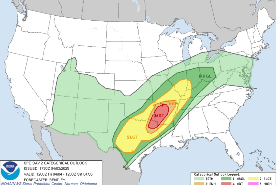
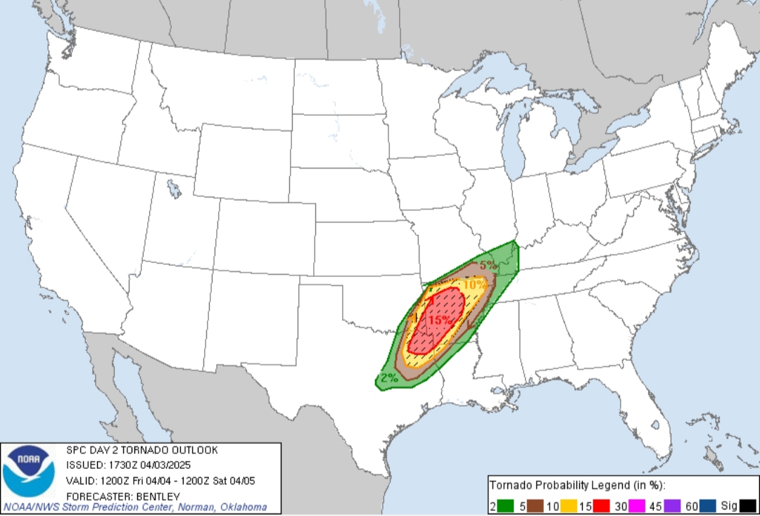
This post was edited on 4/3/25 at 12:40 pm
Posted on 4/3/25 at 12:42 pm to LegendInMyMind
Northeastern Arkansas still under the gun for today and tomorrow

Posted on 4/3/25 at 12:43 pm to ArHog
quote:
2025by ArHog
Northeastern Arkansas still under the gun for today and tomorrow
The whole state is going to wind up taking a wallop this week it seems.
Posted on 4/3/25 at 12:51 pm to WhuckFistle
That’ll buff out
Posted on 4/3/25 at 1:15 pm to ArHog
It’s 54 degrees outside at the moment, feels no where near like it did yesterday
This post was edited on 4/3/25 at 1:16 pm
Posted on 4/3/25 at 1:34 pm to WhuckFistle
12z HRRR around 3pm tomorrow. The next extended run, 18z, will be out next hour.
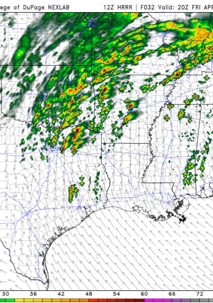
The Mod upgrade for tomorrow is definitely linked to a trend more towards isolated supercells into the afternoon tomorrow.
The Mod upgrade for tomorrow is definitely linked to a trend more towards isolated supercells into the afternoon tomorrow.
This post was edited on 4/3/25 at 1:35 pm
Posted on 4/3/25 at 1:39 pm to WhuckFistle
Chilly in WLR. I heard the weather guy talking about tomorrow’s unstable atmosphere tomorrow and wanted to throw a shoe at the tv. We need to have a quota max of only one outbreak day/year. Quota filled.
Posted on 4/3/25 at 1:40 pm to LegendInMyMind
There are also now three consecutive High Risk days (today-Saturday) for excessive rainfall across the area we've been watching.

 Page 22 of 38

Back to top