- My Forums
- Tiger Rant
- LSU Recruiting
- SEC Rant
- Saints Talk
- Pelicans Talk
- More Sports Board
- Fantasy Sports
- Golf Board
- Soccer Board
- O-T Lounge
- Tech Board
- Home/Garden Board
- Outdoor Board
- Health/Fitness Board
- Movie/TV Board
- Book Board
- Music Board
- Political Talk
- Money Talk
- Fark Board
- Gaming Board
- Travel Board
- Food/Drink Board
- Ticket Exchange
- TD Help Board
Customize My Forums- View All Forums
- Show Left Links
- Topic Sort Options
- Trending Topics
- Recent Topics
- Active Topics
Started By
Message
 1
1

Posted on 5/28/19 at 6:57 pm to rt3
quote:
John Holt
@JohnHoltNews
ALERT: Per @MBogowith "Linwood needs help. Really really needs help." Damage in Linwood, KS is "really really bad".
Posted on 5/28/19 at 6:57 pm to rt3
170-180 mph gate-to-gate shear 
Posted on 5/28/19 at 6:57 pm to 50_Tiger
Inflow still looks wide open. It's sitting in a prime environment. I'm afraid this one has tons of potential to keep going for a while longer. Just hope it cycles down near KC.
Posted on 5/28/19 at 6:57 pm to rt3
TWC showing pics from KC

Posted on 5/28/19 at 7:00 pm to MrLarson
Bonner Springs = fricked

Posted on 5/28/19 at 7:00 pm to MrLarson
Posted on 5/28/19 at 7:00 pm to MrLarson
Sorry if this has already been discussed, but it seems like the US has had two weeks straight of tornado days recently...isn't this a little abnormal even for this time of year?
Posted on 5/28/19 at 7:01 pm to rt3
Posted on 5/28/19 at 7:01 pm to 50_Tiger
TWC showing video from Bonner Springs. THey should have the tornado easily on video shortly
Posted on 5/28/19 at 7:02 pm to zacata88
quote:
Sorry if this has already been discussed, but it seems like the US has had two weeks straight of tornado days recently...isn't this a little abnormal even for this time of year?
The Jet Stream is retreating north, bringing the area of warm and cold convergence back into the midwest/GP area.
Here in Texas we just have lucked out...so far.

Posted on 5/28/19 at 7:06 pm to zacata88
Not like this no. Synoptic setup has just been extremely favorable for this stuff in an area of country that just needs a small push to send it over the edge.
Like throwing a small match on a pile of dry wood covered in gas.
Like throwing a small match on a pile of dry wood covered in gas.
This post was edited on 5/28/19 at 7:07 pm
Posted on 5/28/19 at 7:08 pm to Pedro
Is this still the same area of unstable air sitting around since last weeks PDS in OKie/TX panhandle?
Posted on 5/28/19 at 7:09 pm to 50_Tiger
Over Bonner Springs now headed to Kansas Motor Speedway
Posted on 5/28/19 at 7:09 pm to 50_Tiger
This looks like an El Reno situation where the funnel itself is not indicative of where the tornadic winds reside. The rotation is showing 180 mph sheer.
Big arse vortex
Big arse vortex
Posted on 5/28/19 at 7:11 pm to 50_Tiger

Posted on 5/28/19 at 7:11 pm to 50_Tiger
(no message)
This post was edited on 4/3/23 at 3:15 pm
Posted on 5/28/19 at 7:13 pm to Duke
quote:
Inflow still looks wide open. It's sitting in a prime environment. I'm afraid this one has tons of potential to keep going for a while longer
As soon as I said it...
Last few frames look much better for KC. Like Dr. Forbes on TWC noted, the rain wrapping hopefully disrupted it enough to lift.
Posted on 5/28/19 at 7:13 pm to 50_Tiger
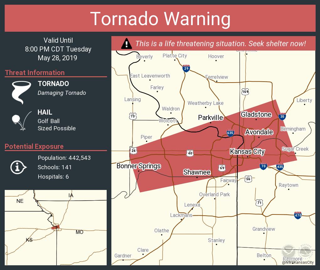
quote:
NWS Kansas City @NWSKansasCity
Tornado Warning including Kansas City MO, Kansas City KS, Shawnee KS until 8:00 PM CDT


Posted on 5/28/19 at 7:14 pm to TH03
missed that

 Page 4 of 10

Popular
Back to top