- My Forums
- Tiger Rant
- LSU Recruiting
- SEC Rant
- Saints Talk
- Pelicans Talk
- More Sports Board
- Coaching Changes
- Fantasy Sports
- Golf Board
- Soccer Board
- O-T Lounge
- Tech Board
- Home/Garden Board
- Outdoor Board
- Health/Fitness Board
- Movie/TV Board
- Book Board
- Music Board
- Political Talk
- Money Talk
- Fark Board
- Gaming Board
- Travel Board
- Food/Drink Board
- Ticket Exchange
- TD Help Board
Customize My Forums- View All Forums
- Show Left Links
- Topic Sort Options
- Trending Topics
- Recent Topics
- Active Topics
Started By
Message
re: Severe Weather Thread: 4/17 --Extra Bonus Easter Edition-- North LA and Northshore
Posted on 4/11/22 at 1:07 pm to Roll Tide Ravens
Posted on 4/11/22 at 1:07 pm to Roll Tide Ravens
What time we expecting this party to pop off?
 1
1


Posted on 4/11/22 at 1:15 pm to beebefootballfan
quote:
You don’t. You sit in Memphis
I admit those storm chasers are pretty damn crazy but I don't think they have an actual death wish like you are implying.

Posted on 4/11/22 at 1:17 pm to deltaland
quote:does it fit the posi track rear end like the 63?
yes he is a My Cousin Vinny fan, but couldn’t find a Skylark so he got the Oldsmobile Starfire which looks identical)
This post was edited on 4/11/22 at 1:18 pm
Posted on 4/11/22 at 1:18 pm to Roll Tide Ravens
Pretty good Twitter thread from a guy who knows a great deal about such things:
@ounwcm (Rick Smith, Coordinating Meteorologist at NWS Norman)
@ounwcm (Rick Smith, Coordinating Meteorologist at NWS Norman)
quote:
Conditional: subject to, implying, or dependent upon a condition.
Tuesday's severe weather potential is HIGHLY conditional, and the condition is that we see storms form at all.
quote:
Several things could happen that could prevent any storms from forming: the cap may be too strong to allow storms to develop, the timing and location of the upper level storm system may not line up just right, and storms to our south could impact storm development here.
quote:
We deal with this forecast challenge at least once every spring, so it's nothing new. It's just not possible to precisely forecast every one of the complex mix of ingredients you need to make a supercell or tornado.
quote:
Most of us won't see a storm on Tuesday. You won't get rain, you won't get damaging hail or wind, and you won't get a tornado. I think most would agree that would be a good thing.
quote:
IF a storm forms, ingredients are in place for it to be significant, and it only takes one storm in the wrong place to make it a really bad day for someone. That's what we should be preparing for, not because it will happen, but because it COULD.
quote:
Any time and energy you put into getting ready for severe weather will not be wasted if nothing happens tomorrow, because there will be other days in the coming weeks when you'll need to get ready again.
Posted on 4/11/22 at 1:18 pm to DVinBR
quote:
what do you look for in a hodograph to see if the storms will be more linear/discrete in nature
This is a good question, and one I would like to spend some time on to answer properly. I'll give you the short version.
In general, a curved hodo suggest a supercell structure where a straight one can suggest more linear but thats just a piece. You can get supercells from a linear hodo and a line even if you have a textbook clockwise curving hodo.
You gotta also consider the boundary thats going to be the surface focus. A deep cold front is probably going to have shear mostly aligned with the boundary, which tends to go linear. Plus you have a lot of forcing to lift from the surface.
A dry line is more subtle and the shear vector can be more perpendicular which would help a discrete mode.
Also capping. With no cap, you'll often get clusters of cells that end up merging and getting into a line. With a cap, you get more isolated storms since they had to break the cap first.
This is again not an exhaustive explanation either but just the basics.
Posted on 4/11/22 at 1:25 pm to Duke
loving the rain cooled surface temps. been hovering in mid 60s all day here in Br
Posted on 4/11/22 at 1:37 pm to deltaland
quote:
The only car they own now is his 1964 metallic mint green Oldsmobile he was restoring (yes he is a My Cousin Vinny fan, but couldn’t find a Skylark so he got the Oldsmobile Starfire which looks identical)

Posted on 4/11/22 at 1:39 pm to LegendInMyMind
quote:
Pretty good Twitter thread from a guy who knows a great deal about such things:
@ounwcm (Rick Smith, Coordinating Meteorologist at NWS Norman)

(
Posted on 4/11/22 at 1:48 pm to SouthernHog
quote:
What time we expecting this party to pop off?
Late afternoon into the evening, assuming we get some storms pop.
Posted on 4/11/22 at 2:43 pm to Duke
That's good info on Tuesday. Does the same thing go for Wednesday's forecast?
Posted on 4/11/22 at 2:44 pm to Champagne
quote:
Does the same thing go for Wednesday's forecast?
Wednesday is going to be more all day as this thing gets moving. Since the southeast and ohio valley isn't as big on keeping a cap on things. Figuring out Wednesday is gonna be challenging.
Posted on 4/11/22 at 2:47 pm to Duke
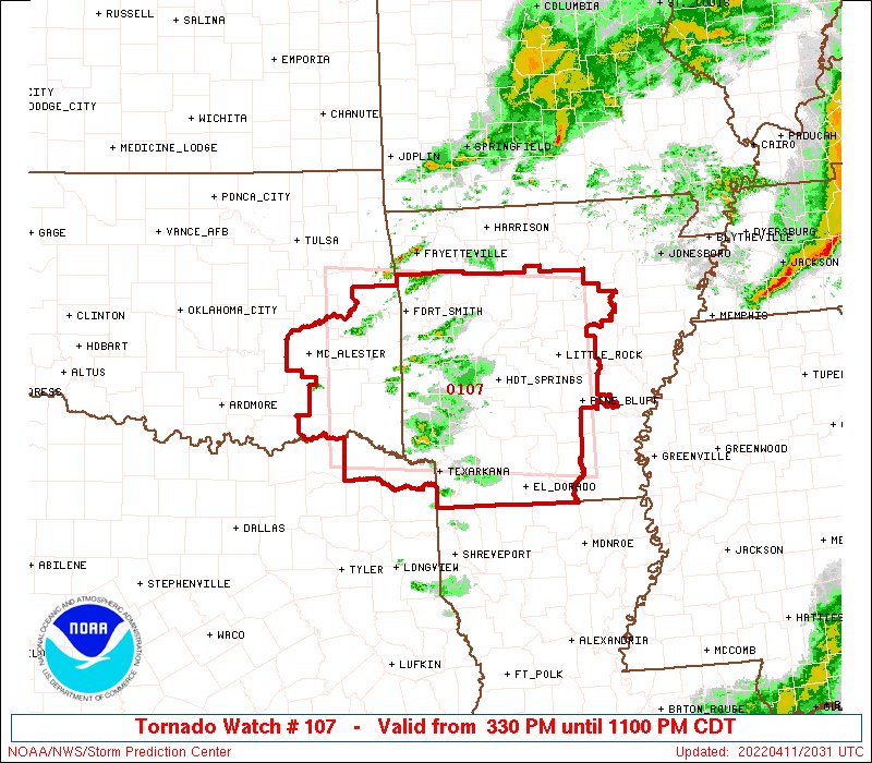
Not official yet, but a tornado watch is more than likely to be issued. Looks like between 6-7 is the start time for central Arkansas.

This post was edited on 4/11/22 at 2:49 pm
Posted on 4/11/22 at 2:52 pm to WhuckFistle
most teardrop looking mofo I've seen the SPC ever issue
I hope Mother Nature ain't getting it tattooed under the eye... means she caught another body
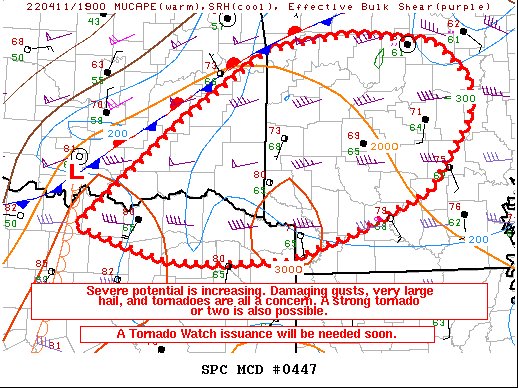
I hope Mother Nature ain't getting it tattooed under the eye... means she caught another body

Posted on 4/11/22 at 2:56 pm to rt3
Im good with that staying north of me considering I have to hope Tuesday goes ok.

Posted on 4/11/22 at 2:59 pm to 50_Tiger
WAFB First Alert Weather
@WAFBweather
·
6m
We continue to track a threat for localized severe weather and localized nuisance flooding. Storms will be most likely Tuesday late afternoon into the evening and Wednesday late afternoon into the night.
Can we have just 1 week without this shite?
@WAFBweather
·
6m
We continue to track a threat for localized severe weather and localized nuisance flooding. Storms will be most likely Tuesday late afternoon into the evening and Wednesday late afternoon into the night.
Can we have just 1 week without this shite?
This post was edited on 4/11/22 at 3:00 pm

Posted on 4/11/22 at 3:11 pm to 50_Tiger
This is staying north of us, right?
Posted on 4/11/22 at 3:29 pm to LSUGrrrl
Sun as peaked back out here in Little Rock and it has become humid. Pretty sure that’s not a good thing.
Posted on 4/11/22 at 3:38 pm to WhuckFistle
Posted on 4/11/22 at 3:39 pm to WhuckFistle
Gorgeous Senior skip day here. Lots of teens in pools this afternoon. Hope you all stay safe!
Posted on 4/11/22 at 3:58 pm to LSUGrrrl
Well shite, Reed Timmer is already chasing/driving on I40.

 Page 11 of 81

Back to top