- My Forums
- Tiger Rant
- LSU Recruiting
- SEC Rant
- Saints Talk
- Pelicans Talk
- More Sports Board
- Coaching Changes
- Fantasy Sports
- Golf Board
- Soccer Board
- O-T Lounge
- Tech Board
- Home/Garden Board
- Outdoor Board
- Health/Fitness Board
- Movie/TV Board
- Book Board
- Music Board
- Political Talk
- Money Talk
- Fark Board
- Gaming Board
- Travel Board
- Food/Drink Board
- Ticket Exchange
- TD Help Board
Customize My Forums- View All Forums
- Show Left Links
- Topic Sort Options
- Trending Topics
- Recent Topics
- Active Topics
Started By
Message
 0
0

Posted on 1/9/20 at 9:46 pm to lsuman25
Now it appears to have the potential for supercell development ahead of the line (for AL on Saturday). If that trend continues, it wouldn't be surprising to see the SPC expand the Enhanced area farther north, covering the large majority of the state of Alabama.
Posted on 1/9/20 at 9:48 pm to rds dc
I regret putting this gif on the first page as I live literally right smack dab in the middle of that bullshite in Benton.
Guess my wife and I will be sleeping in the bathtub tomorrow night.
This post was edited on 1/9/20 at 9:56 pm

Posted on 1/9/20 at 9:51 pm to LegendInMyMind
quote:
Now it appears to have the potential for supercell development ahead of the line (for AL on Saturday). If that trend continues, it wouldn't be surprising to see the SPC expand the Enhanced area farther north, covering the large majority of the state of Alabama.
Yeah, and along with an expansion of the enhanced risk, I would expect to see a moderate risk in there, as well. Again, that’s if the tornado probabilities, particularly with discrete supercells, increases.
ETA: based on model trends and discussions on weather message boards I read, I definitely think the chances of discrete supercells put ahead of the squall line is increasing for Alabama on Saturday. Of course, these would be the ones with the best chance to produce tornadoes, maybe even a few EF-2+ type tornadoes.
This post was edited on 1/9/20 at 9:56 pm

Posted on 1/9/20 at 9:58 pm to Roll Tide Ravens
It's for sure increasing. Last night it seemed that the risk was more for winds than tornadoes. You on weather forums only or do you do discord too?
Posted on 1/9/20 at 10:00 pm to Roll Tide Ravens
quote:
quote:
Now it appears to have the potential for supercell development ahead of the line (for AL on Saturday). If that trend continues, it wouldn't be surprising to see the SPC expand the Enhanced area farther north, covering the large majority of the state of Alabama.
Yeah, and along with an expansion of the enhanced risk, I would expect to see a moderate risk in there, as well. Again, that’s if the tornado probabilities, particularly with discrete supercells, increases.
ETA: based on model trends and discussions on weather message boards I read, I definitely think the chances of discrete supercells put ahead of the squall line is increasing for Alabama on Saturday. Of course, these would be the ones with the best chance to produce tornadoes, maybe even a few EF-2+ type tornadoes.
Right now, it looks like the highest tornado threat will be along I35 tomorrow before things line out and then on Saturday as the system moves into Alabama. It looks like mostly a squall line type setup for Louisiana and Mississippi.
Posted on 1/9/20 at 10:03 pm to GEAUXmedic
Steve Caparotta said New Orleans Office thinks some parts of our area will get upgraded to a Moderate Risk for Saturday.
This post was edited on 1/9/20 at 10:05 pm
Posted on 1/9/20 at 10:24 pm to rds dc
Question:
If the line speeds up, which some mets have mentioned could happen. Would that hamper super cell growth out in front? I don't really know if a faster squall line would hinder or help. Of course, if it could get through the area (AL on Saturday) prior to afternoon heating one would think there would be less instability.
If the line speeds up, which some mets have mentioned could happen. Would that hamper super cell growth out in front? I don't really know if a faster squall line would hinder or help. Of course, if it could get through the area (AL on Saturday) prior to afternoon heating one would think there would be less instability.

Posted on 1/9/20 at 10:33 pm to rds dc
quote:
rds dc
What a kitty
Posted on 1/9/20 at 10:38 pm to rds dc
quote:
Right now, it looks like the highest tornado threat will be along I35 tomorrow before things line out and then on Saturday as the system moves into Alabama. It looks like mostly a squall line type setup for Louisiana and Mississippi.
Really? So NWLA has a less chance of a tornado outbreak than Texas and Alabama?
Posted on 1/10/20 at 12:02 am to rds dc
New Day 1, Moderate Risk expanded back towards DFW

Posted on 1/10/20 at 1:18 am to slackster
What’ is this “Hatched” term all about? I had never heard of it until 10pm News
Posted on 1/10/20 at 1:45 am to GeauxLSUGRL
quote:
What’ is this “Hatched” term all about? I had never heard of it until 10pm News
Hatched means they thing the risk is significant. It's called that cause on the probailistic map they put hatch marks.
Example:
Posted on 1/10/20 at 2:47 am to GEAUXmedic
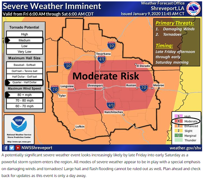
These are currently good from 6am Central time Friday to 6am Saturday.


Posted on 1/10/20 at 4:49 am to slackster
Got my milk sammiches ready here in souther Caddo parish.
Posted on 1/10/20 at 5:52 am to LSURoss
quote:
Got my milk sammiches ready here in souther Caddo parish.
Got a 12 pack and some whiskey here in northern Bossier parish.
Posted on 1/10/20 at 6:15 am to LegendInMyMind
quote:
Now it appears to have the potential for supercell development ahead of the line (for AL on Saturday
Well, that's just a supercell suck me to you.
I hate tornadoes
Posted on 1/10/20 at 6:31 am to East Coast Band

Mesoscale Discussion 0008
NWS Storm Prediction Center Norman OK
0453 AM CST Fri Jan 10 2020
Areas affected...Central/Eastern AR...Far Northeast
LA...Northwest/West-Central MS...Far Southwest TN
Concerning...Outlook upgrade
Valid 101053Z - 101300Z
SUMMARY...An upgrade to Moderate Risk will occur across
central/eastern AR, far northeast LA, northwest/west-central MS, and
far southwest TN with the upcoming 13Z Convective Outlook.
DISCUSSION...Based on recent guidance, the probability for
significant wind gusts (i.e. gusts at or above 75 mph) to occur late
tonight into early Saturday across northeast LA, central/eastern AR,
far southwest TN, and northwest/west-central MS has increased. This
increase in probability merits an increase to Moderate Risk, which
will occur with the upcoming 13Z Convective Outlook. This expanded
Moderate Risk will include Little Rock, AR and Memphis, TN.
More details regarding the meteorological conditions will be
available within the outlook.
Posted on 1/10/20 at 7:05 am to lsuman25

 TORNADO PROBS
  WIND PROBS
  HAIL PROBS
Posted on 1/10/20 at 7:07 am to lsuman25
.South-Central States...
An outbreak of severe thunderstorms is possible later today through
tonight, with the most dangerous portion being tonight into early
Saturday morning with a potential derecho and embedded strong
tornado risk. Primary changes this outlook are to expand the
Moderate Risk east across the Lower MS Valley and increase tornado
probabilities for the evening/overnight period.

 Page 11 of 51

Popular
Back to top