- My Forums
- Tiger Rant
- LSU Recruiting
- SEC Rant
- Saints Talk
- Pelicans Talk
- More Sports Board
- Fantasy Sports
- Golf Board
- Soccer Board
- O-T Lounge
- Tech Board
- Home/Garden Board
- Outdoor Board
- Health/Fitness Board
- Movie/TV Board
- Book Board
- Music Board
- Political Talk
- Money Talk
- Fark Board
- Gaming Board
- Travel Board
- Food/Drink Board
- Ticket Exchange
- TD Help Board
Customize My Forums- View All Forums
- Show Left Links
- Topic Sort Options
- Trending Topics
- Recent Topics
- Active Topics
Started By
Message
re: SEVERE WEATHER: Moderate Risk for parts of LA & MS; Enhanced/Slight risk for most of AL
Posted on 12/16/19 at 9:44 am to Bigbee Hills

Posted on 12/16/19 at 9:44 am to Bigbee Hills
quote:
I'm no meteorologist but that seems to imply one hell of a front coming through to flip the script like that in less than 24 hours...
we screwed
stay safe fellas
 1
1

Posted on 12/16/19 at 9:46 am to Geaux23


Posted on 12/16/19 at 9:55 am to lsuman25
Yep, that means a tornado watch by noon CST for that area.
Posted on 12/16/19 at 10:00 am to lsuman25
That red outlined area will expand east, correct? Or is that area static for this weather event?
Posted on 12/16/19 at 10:03 am to Bigbee Hills
quote:
That red outlined area will expand east, correct? Or is that area static for this weather event?
That’s just an area they outline for where they are discussing issuing a tornado watch. Since those are the places that will be impacted first, those are the first places that will need a tornado watch. That is NOT an outline of the total severe weather threat area, that is just the area they are considering right now to issue a tornado watch for. These are known as mesoscale discussions. They’ll likely have one later today further east when it comes time to discuss issuing a watch for those areas.
This post was edited on 12/16/19 at 10:07 am
Posted on 12/16/19 at 10:06 am to Roll Tide Ravens
10-4 preciate it baw
Posted on 12/16/19 at 10:08 am to Bigbee Hills
Expect a new tornado watch later today for points east of that box already drawn.

Posted on 12/16/19 at 10:08 am to Roll Tide Ravens
Crazy weather
Posted on 12/16/19 at 10:24 am to biggsc
Posted on 12/16/19 at 10:29 am to lsuman25

For Rapides parish, this storm has a nasty hook already.
Posted on 12/16/19 at 10:29 am to lsuman25
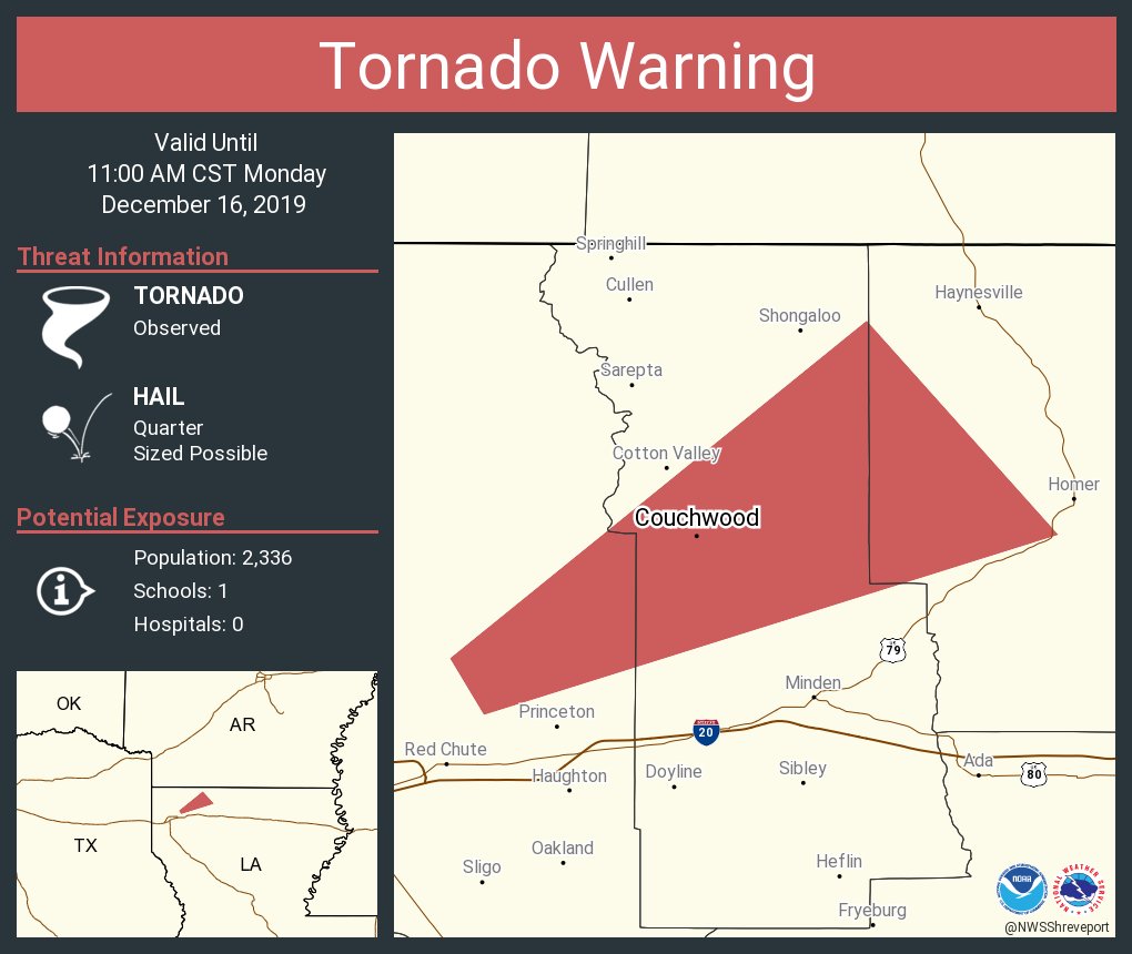
There's another tornado warning in central LA.
Bout time to go ahead and put up the tornado watch box
Bout time to go ahead and put up the tornado watch box
Posted on 12/16/19 at 10:30 am to lsuman25
MODERATE RISK NOW

Posted on 12/16/19 at 10:30 am to biggsc

Posted on 12/16/19 at 10:30 am to lsuman25
Posted on 12/16/19 at 10:31 am to GEAUXmedic

Posted on 12/16/19 at 10:38 am to GEAUXmedic
About 25 miles out from Alexandria

This post was edited on 12/16/19 at 10:39 am
Posted on 12/16/19 at 10:41 am to GEAUXmedic
Not looking good for the people in the path of that
Posted on 12/16/19 at 10:41 am to GEAUXmedic

Posted on 12/16/19 at 10:42 am to GEAUXmedic

This post was edited on 12/16/19 at 10:44 am
Posted on 12/16/19 at 10:44 am to Roll Tide Ravens
Been working outside some this morning, the swampass can confirm the muggy warm over Baton Rouge. Sun is just starting to come out too. The SPC zones look pretty good for today. Marine layer probably muddles convection south of I10. LIX discussion hints at getting some veer back veer on the wind profile (wind working to spin in opposite directions with height) which help limit most of SE LA.
Up toward the mod zone, some model soundings looked awfully concerning yesterday. Especially with the column not saturated all the way up, get those steeper lapse rates going.
Back to work for me, going to be keeping an eye on things though.
Up toward the mod zone, some model soundings looked awfully concerning yesterday. Especially with the column not saturated all the way up, get those steeper lapse rates going.
Back to work for me, going to be keeping an eye on things though.

 Page 3 of 23

Popular
Back to top