- My Forums
- Tiger Rant
- LSU Recruiting
- SEC Rant
- Saints Talk
- Pelicans Talk
- More Sports Board
- Fantasy Sports
- Golf Board
- Soccer Board
- O-T Lounge
- Tech Board
- Home/Garden Board
- Outdoor Board
- Health/Fitness Board
- Movie/TV Board
- Book Board
- Music Board
- Political Talk
- Money Talk
- Fark Board
- Gaming Board
- Travel Board
- Food/Drink Board
- Ticket Exchange
- TD Help Board
Customize My Forums- View All Forums
- Show Left Links
- Topic Sort Options
- Trending Topics
- Recent Topics
- Active Topics
Started By
Message
re: SEVERE WEATHER: Moderate Risk for parts of LA & MS; Enhanced/Slight risk for most of AL
Posted on 12/16/19 at 9:18 pm to Roll Tide Ravens

Posted on 12/16/19 at 9:18 pm to Roll Tide Ravens
quote:
HEADS UP Eoline/Centreville: Confirmed tornado is on the ground SW of Pondville, moving NE toward Eoline & Centreville. TAKE SHELTER!
 1
1

Posted on 12/16/19 at 9:39 pm to Bobby OG Johnson
good size cell heading towards BR

Posted on 12/16/19 at 9:52 pm to Jarlaxle
Tornado watch expanded eastward:


Posted on 12/16/19 at 10:02 pm to Roll Tide Ravens
quote:
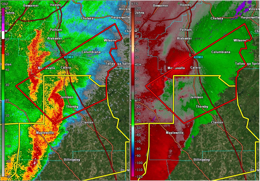
BMX issues Tornado Warning for Bibb, Chilton, Shelby [AL] till 10:45 PM CST
This post was edited on 12/16/19 at 10:03 pm
Posted on 12/16/19 at 10:03 pm to pmacattack
This storm just won’t die. Thought they were going to let the warning go, and then they issue a fresh one.
Posted on 12/16/19 at 10:05 pm to Roll Tide Ravens
Spann was almost convinced it had settled down as well
Posted on 12/16/19 at 10:07 pm to Roll Tide Ravens
They are confirming a tornado on the ground in that Bibb co one.
Might run just south of Montevallo.
Might run just south of Montevallo.

Posted on 12/16/19 at 10:08 pm to Jarlaxle
It's just been a regular thunderstorm in BR. Thinking about you guys that got it worse though. I hope all of the posters in north and CENLA, MS and AL are all good.
Posted on 12/16/19 at 10:10 pm to MrLarson
Yep, there is a debris signature showing up on radar south of Wilton.
Interestingly, this may come close to NWS Birmingham’s office. If it does and they have to seek shelter, NWS Peachtree City (Atlanta) will take over for them.
Interestingly, this may come close to NWS Birmingham’s office. If it does and they have to seek shelter, NWS Peachtree City (Atlanta) will take over for them.
This post was edited on 12/16/19 at 10:11 pm
Posted on 12/16/19 at 10:10 pm to MrLarson
Good call. It's looking pretty speedy from my untrained eye
Posted on 12/16/19 at 10:11 pm to pmacattack
quote:
Spann was almost convinced it had settled down as well
He had pretty much called the all clear except this one storm and it's getting real now for the folks south of Bham.
Posted on 12/16/19 at 10:16 pm to MrLarson
New Orleans is all geared up for this thing. They powered up Generators 5 & 6 earlier this week to accommodate the rainfall and then notified everyone that their technology will be open for business in the event there are any emergencies in the Parish. #NOLASTACKED #STORMfrickED
Posted on 12/16/19 at 10:19 pm to MrLarson
Low CAPE/high shear
Means they can get rotating late into the night.
Means they can get rotating late into the night.
Posted on 12/16/19 at 10:24 pm to Duke
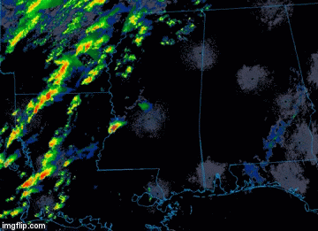
Is there anywhere to find a long loop of the storm that started west of Laurel? I would like to see it from when it was first warned until now.
Posted on 12/16/19 at 10:29 pm to LegendInMyMind
Twitter is probably your best bet.
Search mswx or Laurel and I suspect somebody saved a loop of it.
Search mswx or Laurel and I suspect somebody saved a loop of it.
Posted on 12/16/19 at 10:32 pm to pmacattack
Spann goes off the air as it seems that last tornado warned cell finally wound down
This post was edited on 12/16/19 at 10:33 pm
Posted on 12/16/19 at 10:33 pm to Duke
quote:
We've cancelled the Tornado Warning for Shelby Co. The circulation has weakened and disorganized, still monitoring closely.
For now...
Posted on 12/16/19 at 10:34 pm to Bobby OG Johnson
quote:
Bibb Co SO dispatcher..."needs more deputies to respond to Briarfield Estates for pretty bad damage". Also trees down blocking roadway. 10:29 pm
quote:
Bibb Co SO deputy working their way down Morgan Ln ( i think he said) "heavy debris on roadway". Seeing people out walking around.
This post was edited on 12/16/19 at 10:40 pm
Posted on 12/16/19 at 10:46 pm to pmacattack
Sounds like they may have taken a pretty good hit.
Posted on 12/16/19 at 10:56 pm to LegendInMyMind
Best I could find

 Page 22 of 23

Popular
Back to top