- My Forums
- Tiger Rant
- LSU Recruiting
- SEC Rant
- Saints Talk
- Pelicans Talk
- More Sports Board
- Fantasy Sports
- Golf Board
- Soccer Board
- O-T Lounge
- Tech Board
- Home/Garden Board
- Outdoor Board
- Health/Fitness Board
- Movie/TV Board
- Book Board
- Music Board
- Political Talk
- Money Talk
- Fark Board
- Gaming Board
- Travel Board
- Food/Drink Board
- Ticket Exchange
- TD Help Board
Customize My Forums- View All Forums
- Show Left Links
- Topic Sort Options
- Trending Topics
- Recent Topics
- Active Topics
Started By
Message
re: Severe Weather: March 9-11, 2026
Posted on 3/10/26 at 7:37 pm to NorthEndZone
Posted on 3/10/26 at 7:37 pm to NorthEndZone
Roselawn Indiana has 4000 population. Hopefully that storm misses the main neighborhoods.
This post was edited on 3/10/26 at 7:39 pm
 0
0

Posted on 3/10/26 at 7:38 pm to tWildcat
It had 2 brief touchdowns west and southwest of of OKC. Since then its never dropped back down but sure wanted to.
But the hail storm was bad all over the metro.
Moving east of downtown so only far eastern metro needs worry
But the hail storm was bad all over the metro.
Moving east of downtown so only far eastern metro needs worry

Posted on 3/10/26 at 7:45 pm to OU Guy
Two areas of rotation with the northwest Indiana storm. Looks like the original tornado is occluding and a new one is forming further southeast.
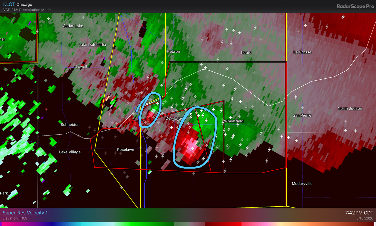
NWS Chicago put this in the newest tornado warning for this storm:
NWS Chicago put this in the newest tornado warning for this storm:
quote:
* At 740 PM CDT, a confirmed large and extremely dangerous tornado was located over DeMotte, moving east at 25 mph. Two circulations are noted, one west of Demotte, and one just to the southeast of Demotte.
This post was edited on 3/10/26 at 7:47 pm
Posted on 3/10/26 at 7:45 pm to OU Guy
Wreck on 1-35 & around Hefner
Likely storm related either heavy rain or stopped traffic over a hill

Likely storm related either heavy rain or stopped traffic over a hill
Posted on 3/10/26 at 7:47 pm to OU Guy
Might could add volcano to the thread title lol
Loading Twitter/X Embed...
If tweet fails to load, click here.Posted on 3/10/26 at 7:49 pm to OU Guy
We are not done with hail several storms SW OK coming up in a few hours


Posted on 3/10/26 at 7:57 pm to OU Guy
Folks in Indinana need some love.
Posted on 3/10/26 at 7:59 pm to kilo
This chaser has the NW Indiana tornado live:
Posted on 3/10/26 at 8:11 pm to Roll Tide Ravens
There's a lot of mess out there tonight. 36 active warnings from the southern border to Michigan.
Posted on 3/10/26 at 8:14 pm to LegendInMyMind
Chicago TV reporting multiple injuries in Kankakee, IL but fortunately no fatalities reported yet.
This post was edited on 3/10/26 at 8:16 pm
Posted on 3/10/26 at 8:16 pm to NorthEndZone
Nasty looking storm north of Peoria. May not have one down at the moment, but it is trying.
Maybe a BWER with it. Hard to tell because the hook wrapped back into the storm.
Maybe a BWER with it. Hard to tell because the hook wrapped back into the storm.
This post was edited on 3/10/26 at 8:18 pm
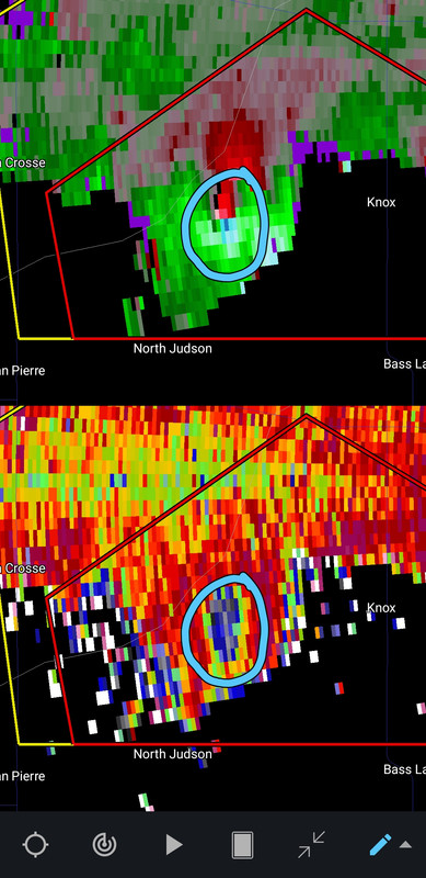
Posted on 3/10/26 at 8:21 pm to NorthEndZone
Probably still on the ground south of La Crosse, IN.
ETA: That area where IA, MO, and IL meet has to be one of the worst radar holes in the country.
ETA: That area where IA, MO, and IL meet has to be one of the worst radar holes in the country.
This post was edited on 3/10/26 at 8:24 pm
Posted on 3/10/26 at 8:27 pm to LegendInMyMind
Tornado warning for Comfort, TX. Another nasty storm with big hail.
Posted on 3/10/26 at 8:29 pm to LegendInMyMind
quote:
That area where IA, MO, and IL meet has to be one of the worst radar holes in the country.
Yep
Posted on 3/10/26 at 8:30 pm to kilo
Confirmed tornado right on top of Mt. Sterling, IA.
Deep TDS with the IN storm.
Deep TDS with the IN storm.
This post was edited on 3/10/26 at 8:32 pm
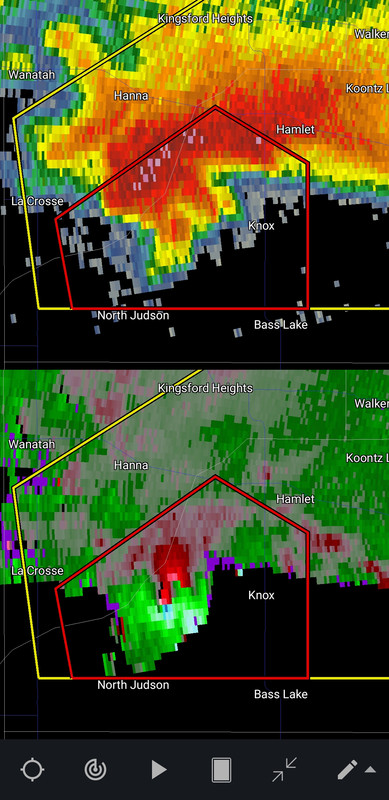
Posted on 3/10/26 at 8:33 pm to LegendInMyMind
PDS warning for North Judson, IN and 2.5 inch hail.
quote:
The National Weather Service in Northern Indiana has issued a
* Tornado Warning for... Central Starke County in northwestern Indiana... South central La Porte County in northwestern Indiana...
* Until 900 PM CDT.
* At 825 PM CDT, a confirmed large and extremely dangerous tornado was located near North Judson, or 10 miles west of Knox, moving east at 20 mph.
This is a PARTICULARLY DANGEROUS SITUATION. TAKE COVER NOW!
HAZARD...Damaging tornado.
SOURCE...Weather spotters confirmed tornado.
IMPACT...You are in a life-threatening situation. Flying debris may be deadly to those caught without shelter. Mobile homes will be destroyed. Considerable damage to homes, businesses, and vehicles is likely and complete destruction is possible.
* The tornado will be near... North Judson around 830 PM CDT. Knox around 845 PM CDT.
Other locations impacted by this tornadic thunderstorm include Toto, Brems, English Lake, and Bass Lake.
PRECAUTIONARY/PREPAREDNESS ACTIONS...
Tornadoes are extremely difficult to see and confirm at night. Do not wait to see or hear the tornado. TAKE COVER NOW!
To report severe weather contact your nearest law enforcement agency. They will send your report to the National Weather Service office in Northern Indiana.
&&
TORNADO...OBSERVED; TORNADO DAMAGE THREAT...CONSIDERABLE; MAX HAIL SIZE...2.50 IN
Issued by North Webster - IN, US, N

Posted on 3/10/26 at 8:37 pm to NorthEndZone
quote:
PDS warning for North Judson, IN and 2.5 inch hail
I live about half an hour or 45 minutes away in Granger, IN. This cell's gonna pass either right over us or a mile or two south.
We're watching the local broadcast pretty intently.
Posted on 3/10/26 at 8:37 pm to kilo
Knox, Indiana is about to take a direct hit from a massive tornado.

 Page 4 of 13

Popular
Back to top