- My Forums
- Tiger Rant
- LSU Recruiting
- SEC Rant
- Saints Talk
- Pelicans Talk
- More Sports Board
- Coaching Changes
- Fantasy Sports
- Golf Board
- Soccer Board
- O-T Lounge
- Tech Board
- Home/Garden Board
- Outdoor Board
- Health/Fitness Board
- Movie/TV Board
- Book Board
- Music Board
- Political Talk
- Money Talk
- Fark Board
- Gaming Board
- Travel Board
- Food/Drink Board
- Ticket Exchange
- TD Help Board
Customize My Forums- View All Forums
- Show Left Links
- Topic Sort Options
- Trending Topics
- Recent Topics
- Active Topics
Started By
Message
re: Severe Weather Info Thread (LA, MS, AL, FL)
Posted on 2/23/16 at 11:50 am to StinkBait72

Posted on 2/23/16 at 11:50 am to StinkBait72
Tornado warning in Carville. Prairieville Gonzales, S Baton Rouge. Until 12:15. EBR Ascension and Iberville.
Iberille ? Rodie gone be all up in this summabitch.
Iberille ? Rodie gone be all up in this summabitch.
 1
1


Posted on 2/23/16 at 11:50 am to tke857
The National Weather Service in New Orleans has issued a Tornado Warning for: East Central Iberville Parish in southeastern Louisiana. South Central East Baton Rouge Parish in southeastern Louisiana. Northwestern Ascension Parish in southeastern Louisiana.
Until 12:15 PM CST.
At 11:45 AM CST, a severe thunderstorm capable of producing a tornado was located over Carville, or 9 miles west of Gonzales. Moving northeast at 25 mph. Hazard, tornado. Source, radar indicated rotation. Impact: flying debris will be dangerous to those caught without shelter. Mobile Homes will be damaged or destroyed. Damage to roofs, windows and vehicles will occur. Tree damage is likely.
Locations impacted include: St. Gabriel, Prairieville, Carville, Geismer, Old Jefferson. Village St. George and Shenandoah. Tornado, radar indicated Hail, <.75IN.

Posted on 2/23/16 at 11:50 am to Duke
The tornado around St. Gabriel doesn't look like much. It's the cells coming in from the southwest that are going to be brutal
Posted on 2/23/16 at 11:50 am to roguetiger15
Our Catholic schools here closed at 11. Son drives he and his sister so no issue for me but we did have about 1:30 notice. Had one little rain band come through so far. Guess better safe than sorry but I surely wouldn't want to be making the calls.

Posted on 2/23/16 at 11:50 am to Winkface
Confirmed in Ascension?
Posted on 2/23/16 at 11:50 am to Duke
Thanks

Posted on 2/23/16 at 11:50 am to Duke
quote:
Ascension Parish has a tornado warning. Also St. Gabe in it as well.
The cell over Carville that's moving across northern AP and southern EBR is warned. Looks like it's headed towards CCLA area. Those storm chasers that were streaming live are headed west towards Baton Rouge now, I'm assuming to see what that cell is doing.
What's coming in over Franklin now is going to be worse for AP, WBR, EBR, and Ibberville later.
This post was edited on 2/23/16 at 11:54 am
Posted on 2/23/16 at 11:52 am to Scoop
It's not, but I can see the spin on radar. Theres still not tons of instability up here. As you mentioned, you can see it rolling off the Gulf with those nasty cells.
Posted on 2/23/16 at 11:54 am to dewster
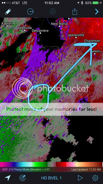
Watch this part of the cells coming in off the gulf.
Posted on 2/23/16 at 11:55 am to Scoop
Posted on 2/23/16 at 11:56 am to Scoop
quote:
Watch this part of the cells coming in off the gulf.
I think I see a hook developing right where you circled it.
This post was edited on 2/23/16 at 11:57 am
Posted on 2/23/16 at 11:56 am to tiger91
(no message)
This post was edited on 2/23/16 at 3:07 pm
Posted on 2/23/16 at 11:56 am to Scoop
Scoop, lightning is really popping off in that region of storms. Lift mode initiated.
Posted on 2/23/16 at 11:57 am to dewster
Looks like the deadly red triangle.
Posted on 2/23/16 at 11:57 am to FunroePete
Oh I know ... just I happened to start watching the Brandon guy when they pulled up at the fast food joint ... and they're still there. lol
Posted on 2/23/16 at 11:58 am to Scoop
quote:
Watch this part of the cells coming in off the gulf.
Good catch. Franklin look out.
Posted on 2/23/16 at 11:58 am to Sir Drinksalot
Where are y'all watching this?
Posted on 2/23/16 at 11:59 am to tiger91
The Mandeville guys trying to get to the lakefront but stuck in traffic
Posted on 2/23/16 at 11:59 am to tiger91

Posted on 2/23/16 at 11:59 am to tiger91
Tornado warning just issued in Mandeville
This post was edited on 2/23/16 at 12:06 pm

 Page 14 of 76

Back to top