- My Forums
- Tiger Rant
- LSU Recruiting
- SEC Rant
- Saints Talk
- Pelicans Talk
- More Sports Board
- Coaching Changes
- Fantasy Sports
- Golf Board
- Soccer Board
- O-T Lounge
- Tech Board
- Home/Garden Board
- Outdoor Board
- Health/Fitness Board
- Movie/TV Board
- Book Board
- Music Board
- Political Talk
- Money Talk
- Fark Board
- Gaming Board
- Travel Board
- Food/Drink Board
- Ticket Exchange
- TD Help Board
Customize My Forums- View All Forums
- Show Left Links
- Topic Sort Options
- Trending Topics
- Recent Topics
- Active Topics
Started By
Message
re: Severe Weather for Friday
Posted on 4/9/21 at 7:13 pm to Bobby OG Johnson
Posted on 4/9/21 at 7:13 pm to Bobby OG Johnson
Is that kumquat-size hail?
ETA: How big is a kumquat?
ETA: How big is a kumquat?
This post was edited on 4/9/21 at 7:14 pm
 2
2

Posted on 4/9/21 at 7:15 pm to LegendInMyMind
I don't know that I remember a day that didn't involve a hurricane with so many storm tracks all pointing different directions.
Posted on 4/9/21 at 7:17 pm to LegendInMyMind
quote:
Is that kumquat-size hail?
ETA: How big is a kumquat?


Posted on 4/9/21 at 7:22 pm to rt3
Big hail core heading right for me in that cell nearing I-20
Posted on 4/9/21 at 7:34 pm to The Boat
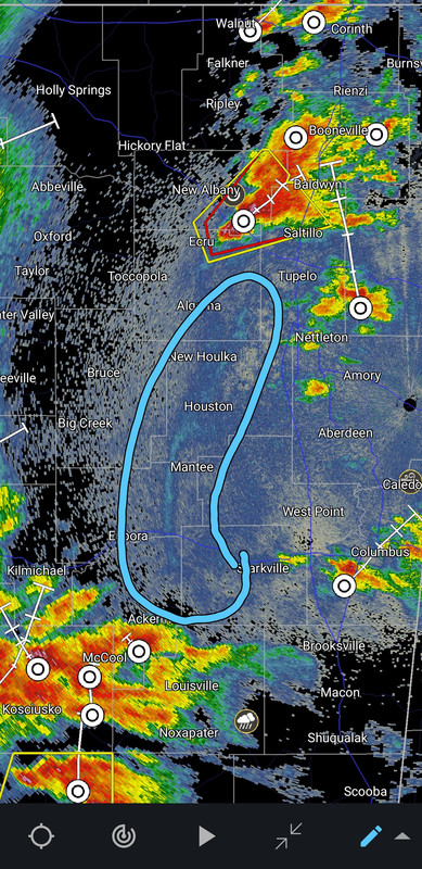
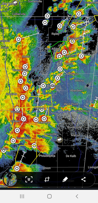
New Albany storm is tornado warned again.

Posted on 4/9/21 at 7:36 pm to The Boat
Butt clinchin
Posted on 4/9/21 at 7:37 pm to jimbeam
Big pea sized hail so far. Nothing too bad
Posted on 4/9/21 at 7:38 pm to LegendInMyMind
quote:
New Albany storm is tornado warned again.
Tornado siren in Tupelo has been going on and off for 30 minutes. Local TV weather station is close to the cell and has a tower camera on it. No visible tornado so far.
Google maps shows traffic stopped both ways for about a mile on i-22 at the Blue Springs exit (Toyota Plant) so it's possible a tornado could have crossed i-22
This post was edited on 4/9/21 at 7:42 pm
Posted on 4/9/21 at 7:39 pm to weadjust
Is this shite hitting northshore later
Posted on 4/9/21 at 7:40 pm to LegendInMyMind
Duke,
What is the boundary visible on radar moving East to West stretching from West of Starkville to near Tupelo?
Please, disregard the dick.
Even more visible now.
What is the boundary visible on radar moving East to West stretching from West of Starkville to near Tupelo?
Please, disregard the dick.
Even more visible now.
This post was edited on 4/9/21 at 7:51 pm
Posted on 4/9/21 at 7:44 pm to weadjust
quote:
Google maps shows traffic stopped both ways for about a mile on i-22 at the Blue Springs exit (Toyota Plant) so it's possible a tornado could have crossed i-22
That storm is damn near stationary.
It is currently moving 9mph.
This post was edited on 4/9/21 at 7:55 pm
Posted on 4/9/21 at 7:57 pm to LegendInMyMind
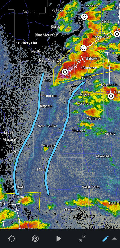
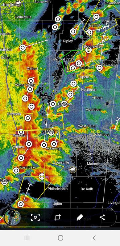
Some kind of gust front outflow boundary
Check out how those storms are firing after it passes from the warm air being shoved up
Pretty sweet to see in real time
Check out how those storms are firing after it passes from the warm air being shoved up
Pretty sweet to see in real time
Posted on 4/9/21 at 8:00 pm to The Boat
quote:
Pretty sweet to see in real time
No shite. I would not want to be under the storm in Northeast MS right now, tornado or not. The damn thing has all but stalled and that boundary is headed toward the storms to the West with new storms firing along it, like you said. Wild.
This post was edited on 4/9/21 at 8:02 pm
Posted on 4/9/21 at 8:04 pm to LegendInMyMind
That storm has been tornado warned twice and now has a flash flood warning and hasn't moved more than 20 miles. It has healthy hail with it and some wind approaching 60mph is possible.
Posted on 4/9/21 at 8:05 pm to LegendInMyMind
Those things are like a mini cold front from the cold downburst air spreading out on the ground and forcing up the warmer air to fire more thunderstorms
Posted on 4/9/21 at 8:08 pm to The Boat
I'm in Arkadelphia, Arkansas tonight, weather forecasts are all over the place.
Should I get my truck somewhere where its protected from hail?
Should I get my truck somewhere where its protected from hail?
Posted on 4/9/21 at 8:10 pm to The Boat
This post was edited on 4/9/21 at 8:15 pm
Posted on 4/9/21 at 8:12 pm to LegendInMyMind
quote:
That storm has been tornado warned twice and now has a flash flood warning and hasn't moved more than 20 miles. It has healthy hail with it and some wind approaching 60mph is possible.
Traffic on that 1-2 mile section of i-22 has been slow or stopped for an hour
Posted on 4/9/21 at 8:15 pm to LegendInMyMind
Looks like we’re about to get a few hour break in north central LA. We got a ton of marble sized hail, flash floods and some strong winds.
I’m worried about what’s coming next. The forecasters where I work (utility industry) put the chances of a “squall line” blowing 60-80mph at 80%.
I’m worried about what’s coming next. The forecasters where I work (utility industry) put the chances of a “squall line” blowing 60-80mph at 80%.
Posted on 4/9/21 at 8:18 pm to 9Fiddy
Those first monster storms took a bunch of the oomph out of things. Just some moderate rain now. It doesn't look to bad north of I-20 for the next little while.

 Page 20 of 28

Popular
Back to top