- My Forums
- Tiger Rant
- LSU Recruiting
- SEC Rant
- Saints Talk
- Pelicans Talk
- More Sports Board
- Coaching Changes
- Fantasy Sports
- Golf Board
- Soccer Board
- O-T Lounge
- Tech Board
- Home/Garden Board
- Outdoor Board
- Health/Fitness Board
- Movie/TV Board
- Book Board
- Music Board
- Political Talk
- Money Talk
- Fark Board
- Gaming Board
- Travel Board
- Food/Drink Board
- Ticket Exchange
- TD Help Board
Customize My Forums- View All Forums
- Show Left Links
- Topic Sort Options
- Trending Topics
- Recent Topics
- Active Topics
Started By
Message
 1
1

Posted on 9/12/20 at 4:01 pm to Large Farva
quote:
000
WTNT44 KNHC 122056
TCDAT4
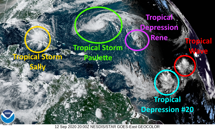
Tropical Storm Sally Discussion Number 5
NWS National Hurricane Center Miami FL AL192020
500 PM EDT Sat Sep 12 2020
Sally continues to gradually become better organized, with
developing convective banding features primarily over the southern
portion of the circulation at this time. Upper-level outflow is
still rather limited over the northern semicircle, possibly due to a
weak upper low near the Georgia/Florida border. The latter feature
is likely to soon move away from the area, however. Based on
earlier scatterometer passes that showed tropical-storm-force winds
over the Straits of Florida, the advisory intensity remains 35 kt.
With very warm waters and a moist tropospheric environment ahead of
Sally, strengthening seems likely. Some increase in westerly shear
over the northern Gulf in 48-72 hours could at least slow down the
intensification process around that time. The official intensity
forecast is not far from the latest model consensus and a little
above the previous forecast.
Fixes from an Air Force Hurricane Hurricane aircraft, radar,
satellite, and surface observations indicate a slow, generally
westward motion of about 280/6 kt. A weakening mid-level high
pressure system to the northeast of Sally should cause a generally
west-northwestward to northwestward motion for the next few days.
Because of the weakening steering currents, the cyclone should
move rather slowly while it approaches the northern Gulf Coast.
However, there is expected to be enough of a narrow north-south
oriented ridge to the east of Sally in 3-4 days to steer the
cyclone northward across the coast. The official track forecast
has been nudged just slightly west of the previous one and lies
between the simple and corrected dynamical track model consensus
predictions.
Users are reminded to not focus on the exact details of the
track or intensity forecast as the average NHC track error at 96 h
is around 150 miles and the average intensity error is around
15 mph. In addition, winds, storm surge, and rainfall hazards will
extend far from the center.
KEY MESSAGES:
1. Life threatening storm surge is possible along the Gulf Coast
beginning on Monday, and a Storm Surge Watch is in effect for areas
outside the southeast Louisiana Hurricane and Storm Damage Risk
Reduction System from the Mouth of the Mississippi River to the
Alabama/Florida border. Residents in these areas should follow any
advice given by local officials.
2. Hurricane conditions are possible by early Tuesday from Grand
Isle, Louisiana to the Alabama/Florida border, including
Metropolitan New Orleans, with tropical storm conditions possible by
Monday.
3. Sally is expected to produce flash flooding across portions of
southern Florida and prolong existing minor river flooding across
central Florida through Sunday. Flash, urban, and minor to moderate
river flooding is likely across portions of the central Gulf Coast
from Sunday through the middle of next week.
4. Tropical storm conditions are possible early next week in
portions of the Florida Panhandle, where a Tropical Storm Watch is
in effect. Wind gusts to tropical-storm force could occur over
portions of the southern Florida Peninsula and the Florida Keys this
evening.
FORECAST POSITIONS AND MAX WINDS
INIT 12/2100Z 25.7N 81.9W 35 KT 40 MPH
12H 13/0600Z 26.4N 83.4W 40 KT 45 MPH
24H 13/1800Z 27.3N 85.3W 50 KT 60 MPH
36H 14/0600Z 28.0N 86.9W 60 KT 70 MPH
48H 14/1800Z 28.5N 88.1W 70 KT 80 MPH
60H 15/0600Z 29.0N 89.0W 75 KT 85 MPH
72H 15/1800Z 29.7N 89.3W 75 KT 85 MPH
96H 16/1800Z 31.1N 89.2W 55 KT 65 MPH...INLAND
120H 17/1800Z 33.1N 87.0W 30 KT 35 MPH...INLAND
$$
Forecaster Pasch

Posted on 9/12/20 at 4:02 pm to rt3
I think it shifted west a quarter of an H

Posted on 9/12/20 at 4:02 pm to Cosmo
Posted on 9/12/20 at 4:02 pm to DVinBR
quote:
why are so many models picking up on putting it at the LA/MS border? what is it timing with to pull it north?

Ridge orients to the east of the storm and this provides for a northern move.
Posted on 9/12/20 at 4:03 pm to Cosmo
Posted on 9/12/20 at 4:07 pm to rt3
quote:Sounds like Jordan Jefferson's LSU football career...
scatterometer passes
Posted on 9/12/20 at 4:07 pm to rt3
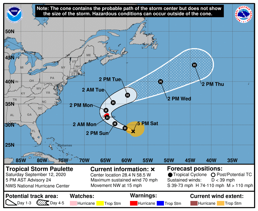
Grand Isle to Florabama is the target as of now...
Near Chandeleur Sound midday Tuesday - Cat 1
quote:
000
WTNT34 KNHC 122048
TCPAT4
BULLETIN
Tropical Storm Sally Advisory Number 5
NWS National Hurricane Center Miami FL AL192020
500 PM EDT Sat Sep 12 2020
...SALLY MOVING SLOWLY AWAY FROM EXTREME SOUTH FLORIDA...
...STORM SURGE AND HURRICANE WATCHES ISSUED FOR PORTIONS OF THE
NORTHERN GULF COAST...
SUMMARY OF 500 PM EDT...2100 UTC...INFORMATION
----------------------------------------------
LOCATION...25.7N 81.9W
ABOUT 30 MI...45 KM SSW OF NAPLES FLORIDA
MAXIMUM SUSTAINED WINDS...40 MPH...65 KM/H
PRESENT MOVEMENT...W OR 280 DEGREES AT 7 MPH...11 KM/H
MINIMUM CENTRAL PRESSURE...1004 MB...29.65 INCHES
WATCHES AND WARNINGS
--------------------
CHANGES WITH THIS ADVISORY:
A Storm Surge Watch is in effect from the Mouth of the Mississippi
River to the Alabama/Florida Border, including Lake Pontchartrain,
Lake Maurepas, Lake Borgne, and Mobile Bay.
A Hurricane Watch is in effect from Grand Isle Louisiana to the
Alabama/Florida border, including Lake Pontchartrain, Lake
Maurepas, and metropolitan New Orleans.
The Tropical Storm watch has been extended westward from the
Okaloosa/Walton County Line to the Alabama/Florida Border.
SUMMARY OF WATCHES AND WARNINGS IN EFFECT:
A Storm Surge Watch is in effect for...
* Mouth of the Mississippi River to the Alabama/Florida Border
* Lake Pontchartrain, Lake Maurepas, and Lake Borgne
* Mobile Bay
A Hurricane Watch is in effect for...
* Grand Isle Louisiana to the Alabama/Florida border
* Lake Pontchartrain and Lake Maurepas including metropolitan New
Orleans
A Tropical Storm Watch is in effect for...
* Alabama/Florida Border to Ochlockonee River Florida
quote:
72H 15/1800Z 29.7N 89.3W 75 KT 85 MPH
Near Chandeleur Sound midday Tuesday - Cat 1
Posted on 9/12/20 at 4:08 pm to lsuman25
Looks like Bermuda may take a direct hit.
Posted on 9/12/20 at 4:08 pm to Cosmo
quote:
I think it shifted west a quarter of an H
Anyone have a new bingo card?
Should I start a spreadsheet for landfall projections?
Posted on 9/12/20 at 4:08 pm to Duke
if there ever was a good point to show that where a storm hits and timing is everything this would be a good one. a small shift makes a pretty dramatic difference on the impacts. going to be interesting to see what this storm does.
This post was edited on 9/12/20 at 4:09 pm

Posted on 9/12/20 at 4:08 pm to fightin tigers
Pilottown
Posted on 9/12/20 at 4:10 pm to jimbeam
I'm thinking city, time, cat, windspeed?

Posted on 9/12/20 at 4:12 pm to fightin tigers
What are the chances we see an EWRC before or at landfall, depending on the RI?
LaBR4
Interim President


LaBR4
Interim President
This post was edited on 9/12/20 at 4:13 pm
Posted on 9/12/20 at 4:13 pm to NorthEndZone
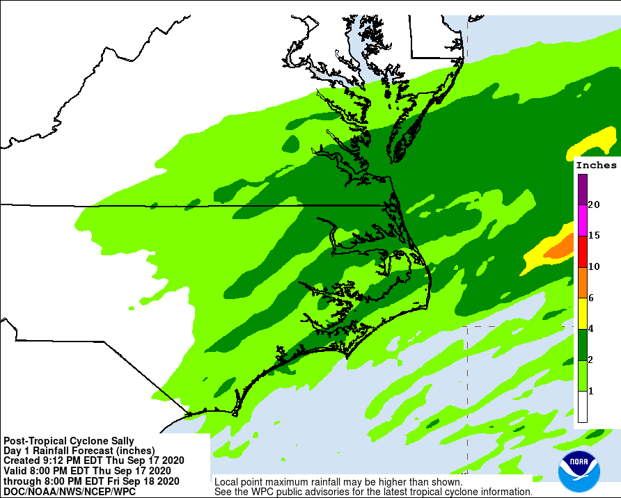
Let's hope the torrential rain stays mostly offshore like the forecast. A slight shift of track westward would bring the huge amounts of rainfall over NOLA.
6 to 10 inches is bad enough but if spread out over time may not be a huge problem.
10 to 15 - even if spread out - will still cause issues.

6 to 10 inches is bad enough but if spread out over time may not be a huge problem.
10 to 15 - even if spread out - will still cause issues.
This post was edited on 9/12/20 at 4:14 pm
Posted on 9/12/20 at 4:13 pm to fightin tigers
Posted on 9/12/20 at 4:20 pm to NorthEndZone
quote:
Grand Isle to Florabama is the target as of now.
One thing we can be certain of then, it won’t hit between Grande Isle and Florabama.
Posted on 9/12/20 at 4:23 pm to OysterPoBoy
Why do you say that?
Posted on 9/12/20 at 4:27 pm to TypoKnig
Posted on 9/12/20 at 4:28 pm to fightin tigers
Cat Island Pass. Terrebonne Parish.

 Page 27 of 298

Back to top