- My Forums
- Tiger Rant
- LSU Recruiting
- SEC Rant
- Saints Talk
- Pelicans Talk
- More Sports Board
- Fantasy Sports
- Golf Board
- Soccer Board
- O-T Lounge
- Tech Board
- Home/Garden Board
- Outdoor Board
- Health/Fitness Board
- Movie/TV Board
- Book Board
- Music Board
- Political Talk
- Money Talk
- Fark Board
- Gaming Board
- Travel Board
- Food/Drink Board
- Ticket Exchange
- TD Help Board
Customize My Forums- View All Forums
- Show Left Links
- Topic Sort Options
- Trending Topics
- Recent Topics
- Active Topics
Started By
Message
re: Preliminary Ratings: Lacombe Tornado - EF1; NOLA/Arabi Tornado - EF3
Posted on 3/21/22 at 9:47 pm to LegendInMyMind
Posted on 3/21/22 at 9:47 pm to LegendInMyMind
Another dual pol radar somewhere South of Palestine, TX would be useful right about now.
 3
3


Posted on 3/21/22 at 9:51 pm to deltaland
quote:
I don’t pay for premium subscription for them to turn off emojis
Take it up with the finance department. I think Fred runs it. Good luck.
Posted on 3/21/22 at 9:51 pm to LegendInMyMind
That storm has been rolling for over 70 miles now and has had a confirmed tornado for a good bit of that distance. It cycled for a bit right over College Station, but has had an observed tornado for more than a half hour now.
Posted on 3/21/22 at 9:52 pm to rmnldr
quote:
Is he wrong tho
Probably not.
Its still got potential in Louisiana, so you want people to be aware and prepared but it wouldnt be a huge surprise if the big impacts were all in Mississippi.
Posted on 3/21/22 at 9:52 pm to LegendInMyMind
That one is pretty much headed dead towards me, Upshur county. The lightning show right now is rad
Posted on 3/21/22 at 9:54 pm to Sao
quote:
That one is pretty much headed dead towards me, Upshur county. The lightning show right now is rad
Don't trust it too much if it weakens. It did that in CS, but was just a cycle.
Posted on 3/21/22 at 9:54 pm to Duke
at least i don't have to travel to jackson tomorrow now
Posted on 3/21/22 at 9:56 pm to Duke
They just made a slick move with the polygon and accounted for that left movement. Good to see them out in front of that.

Posted on 3/21/22 at 9:56 pm to Duke
For sure. Rolling up to Alexandria tomorrow for work and will be prepared to change plans but hoping for the best.
Posted on 3/21/22 at 10:02 pm to LegendInMyMind
I'm under warning. I'll know at 10:27. Better put my dang shoes on.
Posted on 3/21/22 at 10:03 pm to LegendInMyMind
We had a ton of left movers tonight huh?
Get those nearly straight hodographs and we do deviant motion all over the place.
Get those nearly straight hodographs and we do deviant motion all over the place.
Posted on 3/21/22 at 10:05 pm to Duke
any chance this could become a high risk area tomorrow?
Posted on 3/21/22 at 10:06 pm to im4LSU
quote:
Least we don’t have to worry about any touchdowns there
Posted on 3/21/22 at 10:06 pm to rmnldr
Pretty wicked weather moved through here around 5:00 and lingered for a few more hours. My former work leader's house got hit. Hopefully it loses strength overnight.
Posted on 3/21/22 at 10:06 pm to Duke
I made a gif of this one. It was pretty easy to see. I wish the Warning was in time with the loop, though. They caught that movement well.
If you're wondering, so far Radar Omega is worth the $9. The color scheme takes some getting used to, but I think it can be tweaked.
If you're wondering, so far Radar Omega is worth the $9. The color scheme takes some getting used to, but I think it can be tweaked.
This post was edited on 3/21/22 at 10:09 pm
Posted on 3/21/22 at 10:09 pm to Sao
quote:
I'm under warning. I'll know at 10:27. Better put my dang shoes on.
Post back and let us know you're good, baw.
Posted on 3/21/22 at 10:09 pm to DVinBR
quote:
any chance this could become a high risk area tomorrow?
I really doubt it.
ETA: If you want to see what big hail looks like on radar, check the cell just east of Laredo.
This post was edited on 3/21/22 at 10:12 pm
Posted on 3/21/22 at 10:11 pm to Miketheseventh
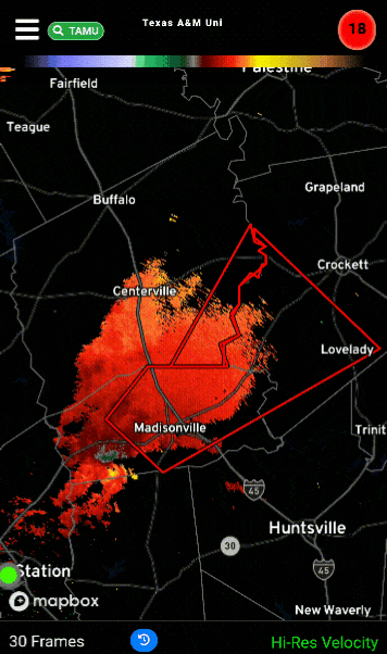
tornado on the ground near Austonio on the Ryan Hall Y'all stream
Posted on 3/21/22 at 10:13 pm to Duke
quote:
ETA: If you want to see what big hail looks like on radar, check the cell just east of Laredo.
South Texas doing South Texas things.
Posted on 3/21/22 at 10:14 pm to Duke
Yeah that huge supercell east of Laredo is baseball sized hail
Severe Weather Statement
National Weather Service Corpus Christi TX
1006 PM CDT Mon Mar 21 2022
TXC131-479-220330-
/O.CON.KCRP.SV.W.0001.000000T0000Z-220322T0330Z/
Duval TX-Webb TX-
1006 PM CDT Mon Mar 21 2022
...A SEVERE THUNDERSTORM WARNING REMAINS IN EFFECT UNTIL 1030 PM CDT
FOR WEST CENTRAL DUVAL AND SOUTHEASTERN WEBB COUNTIES...
At 1004 PM CDT, a severe thunderstorm was located 9 miles northwest
of Aguilares, or 15 miles east of Laredo, moving northeast at 40 mph.
THIS IS A DESTRUCTIVE STORM FOR LAREDO RANCHETTES AND RANCHITOS LAS
LOMAS.
HAZARD...Baseball size hail and 70 mph wind gusts.
SOURCE...Radar indicated.
IMPACT...People and animals outdoors will be severely injured.
Expect shattered windows, extensive damage to roofs,
siding, and vehicles.
Locations impacted include...
Oilton, Ranchitos Las Lomas, Mirando City and Aguilares.
This includes US Highway 59 between mile markers 784 and 822.
This post was edited on 3/21/22 at 10:16 pm

 Page 33 of 94

Popular
Back to top