- My Forums
- Tiger Rant
- LSU Recruiting
- SEC Rant
- Saints Talk
- Pelicans Talk
- More Sports Board
- Coaching Changes
- Fantasy Sports
- Golf Board
- Soccer Board
- O-T Lounge
- Tech Board
- Home/Garden Board
- Outdoor Board
- Health/Fitness Board
- Movie/TV Board
- Book Board
- Music Board
- Political Talk
- Money Talk
- Fark Board
- Gaming Board
- Travel Board
- Food/Drink Board
- Ticket Exchange
- TD Help Board
Customize My Forums- View All Forums
- Show Left Links
- Topic Sort Options
- Trending Topics
- Recent Topics
- Active Topics
Started By
Message
re: Official Harvey Observation Thread
Posted on 8/27/17 at 1:21 am to GEAUXmedic
Posted on 8/27/17 at 1:21 am to GEAUXmedic
3hr rainfall rates, ending at 12:30AM.
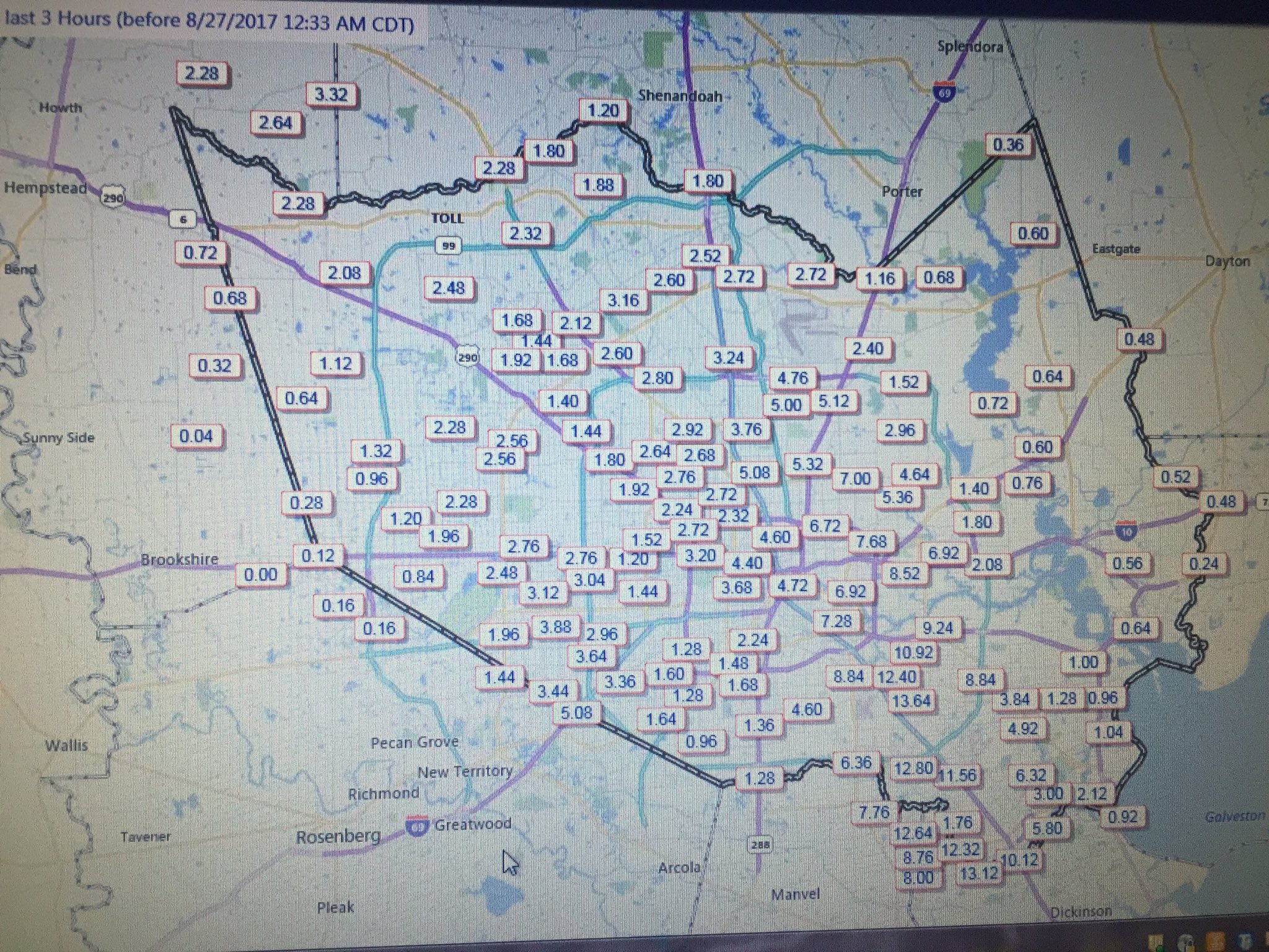
13.64" SE of Houston.
13.64" SE of Houston.
 2
2


Posted on 8/27/17 at 1:29 am to slackster
Drains in Fall Creek are working like champs as always, but my street is getting flooded right now. Never seen it like this. Not a good sign for the areas around us.
Posted on 8/27/17 at 1:31 am to GRTiger
Poor Houston. The radar shows them getting hammered right now. Praying for Texas
Posted on 8/27/17 at 1:57 am to slackster
quote:
13.64" in 3 Hrs
That's right around hobby airport. Heard some reports earlier that they got 10" of that rain in a 90 minute timespan
Posted on 8/27/17 at 2:32 am to HYDRebs
Posted on 8/27/17 at 2:43 am to LakeViewLSU
Im sure La Reunion Island's obscene rainfall records have been posted.
LINK
LINK
quote:
Time Period Amount Location Tropical Cyclone Date
12 hr 1144 mm (45.0") Foc-Foc, La Reunion Denise 7-8 January, 1966
24 hr 1825 mm (71.8") Foc-Foc, La Reunion Denise 7-8 January, 1966
48 hr 2467 mm (97.1") Aurere, La Reunion Unnamed 8-10 April, 1958
72 hr 3929 mm (154.6") Commerson, La Reunion Gamede 24-27 February, 2007
10 day 5678 mm (223.5") Commerson, La Reunion Hyacinthe 18-27 January, 1980
15 day 6083 mm (239.5") Commerson, La Reunion Hyacinthe 14-28 January, 1980
This post was edited on 8/27/17 at 2:49 am

Posted on 8/27/17 at 3:00 am to LakeViewLSU

This post was edited on 8/27/17 at 3:00 am

Posted on 8/27/17 at 3:11 am to slackster
first look this morning...
buffalo bayou hitting action stage
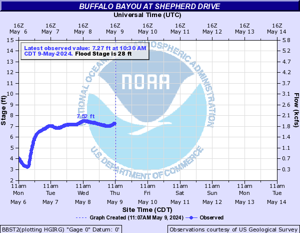
white oak hitting major flood stage

both forecast to get a LOT worse
buffalo bayou hitting action stage
white oak hitting major flood stage
both forecast to get a LOT worse
Posted on 8/27/17 at 4:03 am to baytiger
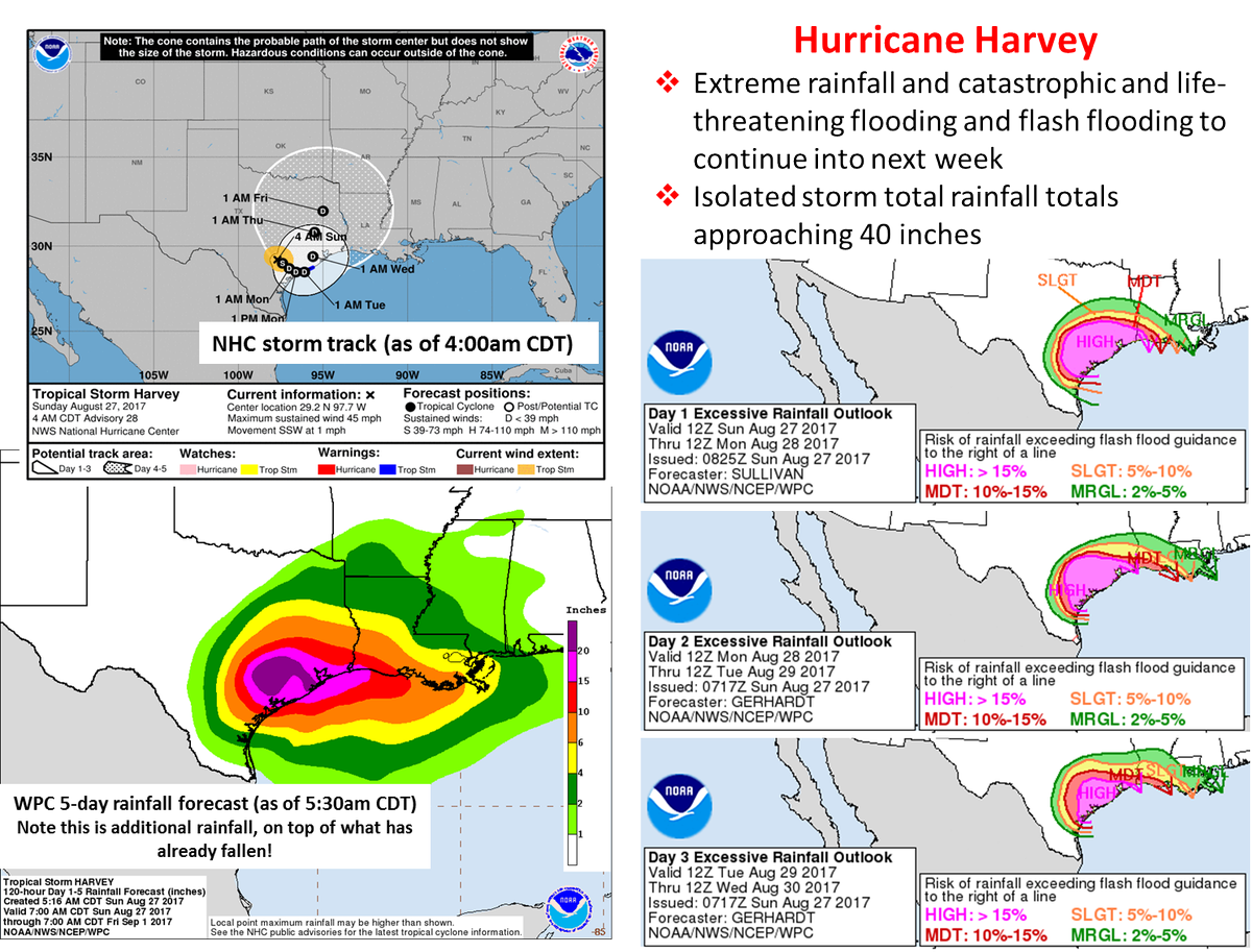
New NHC forecast has Harvey dipping offshore again. Our forecast puts it a little further offshore than theirs which might give it time to reintensify.
Posted on 8/27/17 at 4:06 am to baytiger
quote:
New NHC forecast has Harvey dipping offshore again. Our forecast puts it a little further offshore than theirs which might give it time to reintensify.
Is your forecast still showing it coming back into galveston?
Posted on 8/27/17 at 4:24 am to GEAUXmedic
further west than that... but keeping it a depression for now.

Posted on 8/27/17 at 5:50 am to rds dc
@ABC13Elita 6m
Per @hcfcd RECORD Flooding. Above 500 year water levels. Bayous and creeks going overbanks. Rooftop flooding likely
@TravisABC13
#BREAKING: @hcfcd reports that "rooftop flooding" is likely along Hunting Bayou at I-10 where it is 8 feet overbanks.
Per @hcfcd RECORD Flooding. Above 500 year water levels. Bayous and creeks going overbanks. Rooftop flooding likely
@TravisABC13
#BREAKING: @hcfcd reports that "rooftop flooding" is likely along Hunting Bayou at I-10 where it is 8 feet overbanks.
Posted on 8/27/17 at 5:56 am to rds dc
From NWS Houston:
This is a FLASH FLOOD EMERGENCY from the Bay City area to Wharton to
Waller across the Houston Metro area to Stafford to Friendswood to
League City and Santa Fe. Travel across the area is severely hampered
if not impossible. Over 1000 high water rescues have been performed
and in some places emergency crews cannot reach the worst hit areas.
5 fatalities have been reported. Some people are using attics and
the second floor to escape the rising flood waters.
Posted on 8/27/17 at 6:00 am to rds dc
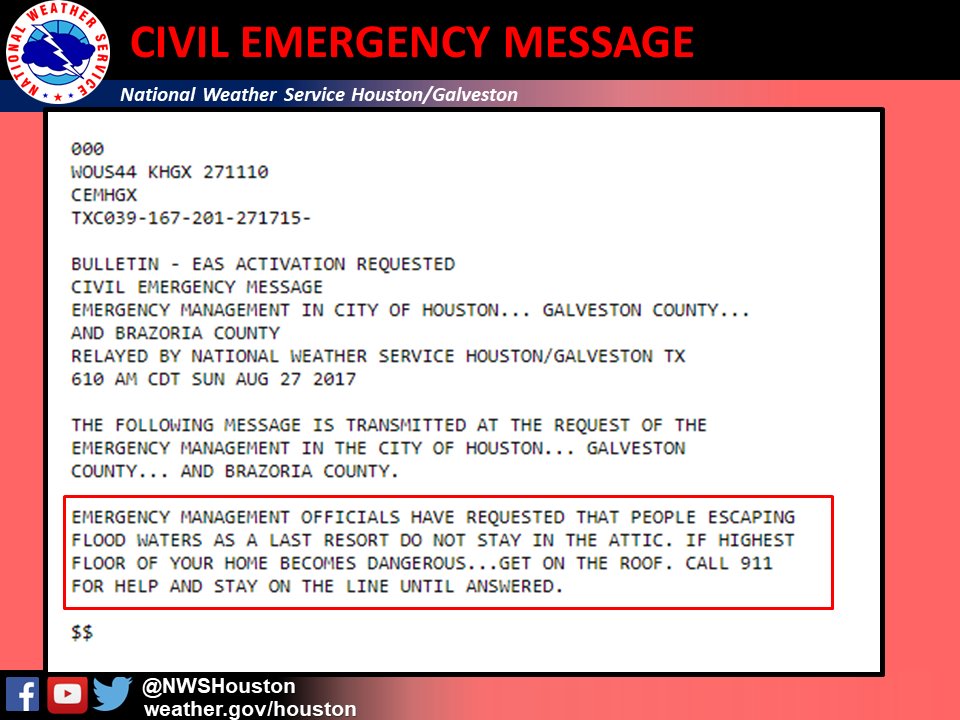
NWS Houston?Verified account @NWSHouston 5m5 minutes ago
More
WANT TO STRESS Persons should NOT go into their attics, but instead onto the roof, & if calling 911 stay on the line until it is answered!!
More
WANT TO STRESS Persons should NOT go into their attics, but instead onto the roof, & if calling 911 stay on the line until it is answered!!
Posted on 8/27/17 at 6:10 am to rds dc
Area Forecast Discussion
National Weather Service Houston/Galveston TX
601 AM CDT Sun Aug 27 2017
...FLASH FLOOD EMERGENCY FOR LIFE-THREATENING CATASTROPHIC FLOODING...
.DISCUSSION...
Epic and catastrophic flooding has occurred in and around the
Houston and Galveston areas and surrounding communities overnight,
and very heavy rains continue falling across these areas early
this morning. Rainfall totals between Saturday evening and early
this morning have totaled 15 to 30 inches. Tropical Storm Harvey
is approximately 50 miles east southeast of San Antonio and has
remained nearly stationary all night long. Showers and thunderstorms
along Harvey's feeder bands have spread 4 to 6 inch per hour producing
rainfall rates resulting in this historic event. Activity continues
spreading across already devastated areas with hourly rainfall
rates averaging around 4 to 5 inches in the Matagorda-Brazoria
County storms and around 6 to 7 inches in the Galveston-Harris
County area storms. We might get a break from the rain some time
later today, but additional storm development is likely overnight.
It is possible that these new storms could become concentrated a
little further westward than this morning's activity. However,
with Harvey expected to remain in the same general area between
its current location and the coast over the next several days,
additional life-threatening rainfall totals of 15 to 25 inches
with isolated higher amounts are possible across the Flash Flood
Watch area over the next several days, and results could be
devastating if any of these rains fall where catastrophic flooding
has already occurred. 42

Posted on 8/27/17 at 6:11 am to baytiger
Bay,
How much of an east shift has taken place in the forecast? I'm in Lake Charles and we are literally on the edge of this. All it takes would be a small shift east and we will be having issues here.
How much of an east shift has taken place in the forecast? I'm in Lake Charles and we are literally on the edge of this. All it takes would be a small shift east and we will be having issues here.
Posted on 8/27/17 at 6:12 am to Prominentwon
....I think we were posting at the same time...

Posted on 8/27/17 at 6:34 am to Prominentwon
quote:
How much of an east shift has taken place in the forecast? I'm in Lake Charles and we are literally on the edge of this. All it takes would be a small shift east and we will be having issues here.
This..

 Page 31 of 38

Popular
Back to top