- My Forums
- Tiger Rant
- LSU Recruiting
- SEC Rant
- Saints Talk
- Pelicans Talk
- More Sports Board
- Coaching Changes
- Fantasy Sports
- Golf Board
- Soccer Board
- O-T Lounge
- Tech Board
- Home/Garden Board
- Outdoor Board
- Health/Fitness Board
- Movie/TV Board
- Book Board
- Music Board
- Political Talk
- Money Talk
- Fark Board
- Gaming Board
- Travel Board
- Food/Drink Board
- Ticket Exchange
- TD Help Board
Customize My Forums- View All Forums
- Show Left Links
- Topic Sort Options
- Trending Topics
- Recent Topics
- Active Topics
Started By
Message
re: Official Harvey Observation Thread
Posted on 8/26/17 at 11:46 am to slackster

Posted on 8/26/17 at 11:46 am to slackster
quote:
Maybe it's just me, but that website has a vibe of "it's over, and it wasn't that bad for us."
People simply get too caught up in the winds and do not respect the rain that isn't going anywhere soon.
In fairness, this will be the third year in a row that Houston has been hit with catastrophic flooding. At this point in the storm, the unpredictable has somewhat, though not entirely, passed(winds, tornados). Based on the last two flooding events, they already have a good idea of what's coming, what areas will be flooded, and where you can/can't go when the water rises.
This post was edited on 8/26/17 at 11:47 am
 1
1

Posted on 8/26/17 at 11:48 am to baytiger

Posted on 8/26/17 at 11:53 am to Uncle JackD
Per wiki
LINK
quote:
Because Katrina had just weakened from Category 4 and due to the shape of the coastline, sustained Category 4 winds likely existed on land while the eye was over water. At landfall, hurricane-force winds extended 120 miles (190 kilometres) from the center, the storm's pressure was 920 millibars (27 inches of mercury), and its forward speed was 15 mph (24 km/h).
LINK

Posted on 8/26/17 at 11:58 am to NYNolaguy1
Posted on 8/26/17 at 12:01 pm to GEAUXmedic
Not sure if this has already been posted, but our old friend supernovasky is running a Reddit live thread on the Harvey.
LINK
LINK

Posted on 8/26/17 at 12:19 pm to cgrand
(no message)
This post was edited on 4/11/23 at 3:31 am
Posted on 8/26/17 at 12:23 pm to Fatty Magoo
West Houston has been pretty lucky so far outside Sugarland. That band to the east just missed us.
Still a long ways to go
Still a long ways to go
Posted on 8/26/17 at 12:25 pm to baytiger
quote:
New round of feeder bands coming up Galveston Bay...
Cleveland, TX is in trouble. 4 inches in the last 3 hours, 6 in the last 6 hours, plus the bands on the way...


Posted on 8/26/17 at 12:26 pm to tylercsbn9
quote:
West Houston has been pretty lucky so far outside Sugarland. That band to the east just missed us.
really everyone from Montrose to west Houston has gotten a huge break this morning.
pasadena to northwest houston has gotten hammered
This post was edited on 8/26/17 at 12:27 pm
Posted on 8/26/17 at 12:29 pm to TheChosenOne
quote:
n fairness, this will be the third year in a row that Houston has been hit with catastrophic flooding. At this point in the storm, the unpredictable has somewhat, though not entirely, passed(winds, tornados). Based on the last two flooding events, they already have a good idea of what's coming, what areas will be flooded, and where you can/can't go when the water rises.
Fair enough.
Latest 18hr rainfall totals from the HRRR - 25" totals near The Woodlands.

Posted on 8/26/17 at 12:34 pm to tylercsbn9
We were in between bans almost all morning in south Katy. Hoping it stays that way
Posted on 8/26/17 at 12:43 pm to Dire Wolf
quote:
pasadena to northwest houston has gotten hammered
I assume you mean NE
Been lucky in Cypress
This post was edited on 8/26/17 at 12:44 pm
Posted on 8/26/17 at 12:49 pm to slackster
quote:
Latest 18hr rainfall totals from the HRRR - 25" totals near The Woodlands.
What is really worrisome, this is just day 1 of a potentially week long event.
Posted on 8/26/17 at 12:49 pm to tylercsbn9
quote:
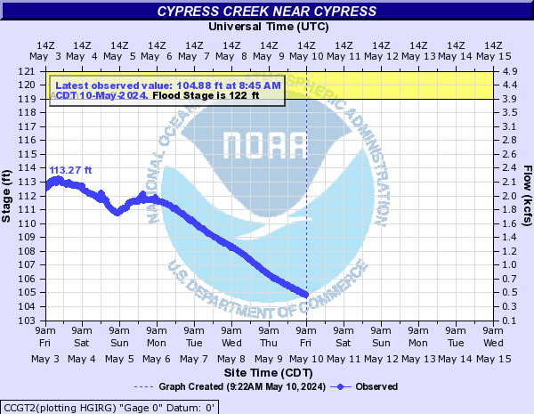
Been lucky in Cypress
Watch Cypress Creek. Supposed to top where it got in April 2016.
Posted on 8/26/17 at 12:52 pm to slackster
The West Gulf RFC is going to have to update river forecasts all in the Houston area. They're too bullish on the west side of Houston and not nearly bullish enough on the east side.
Posted on 8/26/17 at 12:55 pm to slackster
My gf is flying Southwest (Hobby) back from Vegas. Flight was for tomorrow night, but the airline is doing a really stand-up thing and allowing her to reschedule her flight whenever she wants.
I have no idea what to tell her though. My area (Rice Military) seems fine but I have no idea how bad it is elsewhere, and I know that Allen Pkwy is known to flood faster than other major roads and that is a key to getting home.
I have no idea what to tell her though. My area (Rice Military) seems fine but I have no idea how bad it is elsewhere, and I know that Allen Pkwy is known to flood faster than other major roads and that is a key to getting home.
Posted on 8/26/17 at 1:01 pm to cgrand
the fishing center in POC

Posted on 8/26/17 at 1:05 pm to tylercsbn9
quote:
West Houston has been pretty lucky so far outside Sugarland. That band to the east just missed us.
Still a long ways to go
Glad to hear it, but stay alert
The rain falling along your drainage basins matters as much as that on top of your location. With the persistent se flow pushing back at the outlets into the gulf, waterways will slow down in drainage ability.
Posted on 8/26/17 at 1:06 pm to slackster
quote:
Watch Cypress Creek. Supposed to top where it got in April 2016.
Well I am far enough away from Cypress Creek that I'm not too worried. My office on the other hand.............
I have little cypress creek a little bit from my house. We had a few homes get water during tax day. They back up to a field and I think there is some sort of pond back there that went over. I think as long as the rain is manageable we should be okay. The houses on the other side of the street are also set lower than my side which hurt them.
We also had morons that put their trash out since the next day was trash day so some drains got clogged
Posted on 8/26/17 at 1:08 pm to slackster
quote:
The West Gulf RFC is going to have to update river forecasts all in the Houston area. They're too bullish on the west side of Houston and not nearly bullish enough on the east side.
The various weather centers typically take very conservative approaches. My guess they hold tight, esp. since Harvey isn't supposed to move much over the next 48 hrs and hard to forecast mesoscale processes will determine rainfall placement.

 Page 17 of 38

Popular
Back to top