- My Forums
- Tiger Rant
- LSU Recruiting
- SEC Rant
- Saints Talk
- Pelicans Talk
- More Sports Board
- Coaching Changes
- Fantasy Sports
- Golf Board
- Soccer Board
- O-T Lounge
- Tech Board
- Home/Garden Board
- Outdoor Board
- Health/Fitness Board
- Movie/TV Board
- Book Board
- Music Board
- Political Talk
- Money Talk
- Fark Board
- Gaming Board
- Travel Board
- Food/Drink Board
- Ticket Exchange
- TD Help Board
Customize My Forums- View All Forums
- Show Left Links
- Topic Sort Options
- Trending Topics
- Recent Topics
- Active Topics
Started By
Message
re: Official Harvey Observation Thread
Posted on 8/26/17 at 1:34 am to Gris Gris
Posted on 8/26/17 at 1:34 am to Gris Gris
Ok, so I haven't read through all the threads and just got home from work to actually get reliably info on this storm. Am I right that the winds and surge were'nt as catastrophic as expected?
Watching the news, everything seems calm in the places they're reporting from. Are they just away from the worst of it right now?
Watching the news, everything seems calm in the places they're reporting from. Are they just away from the worst of it right now?
 2
2

Posted on 8/26/17 at 1:52 am to supadave3
Just updating Webster Texas. no flooding, still have power. Gonna finish this glass of wine and head to bed.

Posted on 8/26/17 at 1:53 am to supadave3
The rain has always been the concern. The wind was as expected from a Cat 4, but it doesn't last long.
Posted on 8/26/17 at 2:11 am to PapaPogey
What about the surge? That usually brings the most damage and I haven't heard anything about it.

Posted on 8/26/17 at 2:14 am to supadave3
I don't live near the coast so not sure if it means much but TV just said it's low tide now.
Posted on 8/26/17 at 2:32 am to noonan
Getting lots of rain here in Katy
Posted on 8/26/17 at 3:13 am to bnb9433
You still have power?

Posted on 8/26/17 at 3:15 am to supadave3
quote:Looking quickly at a couple tide gauges (PTAT2 and RCPT2), it doesn't seem like the surge was particularly impressive. I posted yesterday that because the storm blew up so quickly that the surge wouldn't have time to ramp up like it does on most large storms, so we could be seeing a lower than expected surge amount. Hopefully that was the case?
What about the surge? That usually brings the most damage and I haven't heard anything about it.
Posted on 8/26/17 at 3:22 am to Walt OReilly
quote:
You still have power?
Yes....rain/wind has slacked off

Posted on 8/26/17 at 3:24 am to bnb9433

Posted on 8/26/17 at 3:35 am to GEAUXmedic

Posted on 8/26/17 at 4:07 am to GEAUXmedic
Posted on 8/26/17 at 4:09 am to GEAUXmedic
Hurricane Harvey Advisory Number 24
NWS National Hurricane Center Miami FL AL092017
400 AM CDT Sat Aug 26 2017
...HARVEY MOVING SLOWLY INLAND OVER SOUTH TEXAS...
...CATASTROPHIC FLOODING EXPECTED OVER THE NEXT FEW DAYS DUE TO
HEAVY RAINFALL...
SUMMARY OF 400 AM CDT...0900 UTC...INFORMATION
----------------------------------------------
LOCATION...28.5N 97.2W
ABOUT 30 MI...50 KM SW OF VICTORIA TEXAS
ABOUT 105 MI...170 KM SE OF SAN ANTONIO TEXAS
MAXIMUM SUSTAINED WINDS...100 MPH...155 KM/H
PRESENT MOVEMENT...NW OR 325 DEGREES AT 6 MPH...9 KM/H
MINIMUM CENTRAL PRESSURE...963 MB...28.44 INCHES
WATCHES AND WARNINGS
--------------------
CHANGES WITH THIS ADVISORY:
The Hurricane Warning and Storm Surge Warning have been
discontinued south of Baffin Bay. The Hurricane Warning north of
Port O'Connor to Sargent has been changed to a Tropical Storm
Warning.
SUMMARY OF WATCHES AND WARNINGS IN EFFECT:
A Storm Surge Warning is in effect for...
* Baffin Bay to High Island Texas
A Hurricane Warning is in effect for...
* Baffin Bay to Port O'Connor Texas
A Tropical Storm Warning is in effect for...
* North of Port O'Connor to High Island Texas
-------------------------------------------------------
DISCUSSION AND 48-HOUR OUTLOOK
------------------------------
At 400 AM CDT (0900 UTC), the eye of Hurricane Harvey was located
by NOAA Doppler radar near latitude 28.5 North, longitude 97.2 West.
Harvey is moving toward the northwest near 6 mph (9 km/h). Harvey
is expected to slow down through the day and meander over
southeastern Texas through the middle of next week.
Doppler radar data indicate that maximum sustained winds have
decreased to near 100 mph (155 km/h) with higher gusts. Additional
weakening is forecast, and Harvey is likely to become a tropical
storm later today.
Hurricane-force winds extend outward up to 35 miles (55 km) from the
center, and tropical-storm-force winds extend outward up to 140
miles (220 km).
The estimated minimum central pressure is 963 mb (28.44 inches).
Almost 10 inches of rain have already been reported at a few
locations in southeastern Texas.
Posted on 8/26/17 at 4:12 am to GEAUXmedic
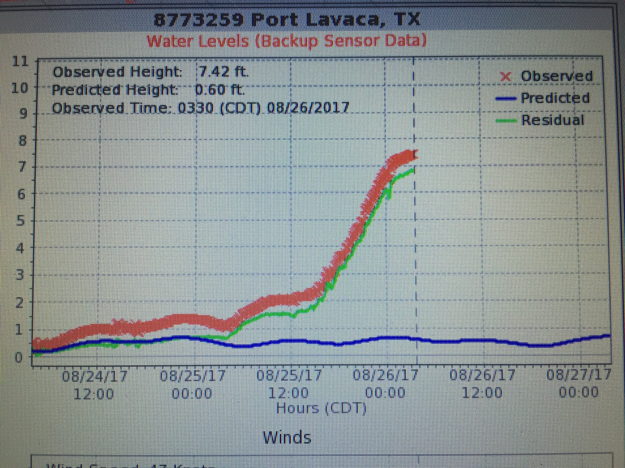
more low surge totals. That's some good news out of Harvey
cat 4 storms are baseline correlated with 13-18 feet of storm surge.. but storm surge has a lot of factors, including size of storm and time spent at intensity.
cat 4 storms are baseline correlated with 13-18 feet of storm surge.. but storm surge has a lot of factors, including size of storm and time spent at intensity.
Posted on 8/26/17 at 4:18 am to baytiger
It's still rising, but looks to be leveling off slowly.
Posted on 8/26/17 at 4:36 am to baytiger
Still a Cat 2 and looking impressive this morning.

Posted on 8/26/17 at 4:40 am to baytiger
Latest QPF:

Posted on 8/26/17 at 4:41 am to baytiger
Tornado warning in my area now, Fort Bend county
Posted on 8/26/17 at 4:56 am to bnb9433
NW of Freeport

Posted on 8/26/17 at 4:57 am to GEAUXmedic
Wow

 Page 11 of 38

Popular
Back to top