- My Forums
- Tiger Rant
- LSU Recruiting
- SEC Rant
- Saints Talk
- Pelicans Talk
- More Sports Board
- Fantasy Sports
- Golf Board
- Soccer Board
- O-T Lounge
- Tech Board
- Home/Garden Board
- Outdoor Board
- Health/Fitness Board
- Movie/TV Board
- Book Board
- Music Board
- Political Talk
- Money Talk
- Fark Board
- Gaming Board
- Travel Board
- Food/Drink Board
- Ticket Exchange
- TD Help Board
Customize My Forums- View All Forums
- Show Left Links
- Topic Sort Options
- Trending Topics
- Recent Topics
- Active Topics
Started By
Message
re: Morganza Spillway may or may not open for a 3rd time -- lack of clear info from ACoE
Posted on 5/30/19 at 12:12 pm to ike221

Posted on 5/30/19 at 12:12 pm to ike221
quote:
How to sinking a barge in Bayou Chene prevent backwater flooding?
I don't understand this, either. Can someone please fill me in. Use small words, too, because I'm kinda stupid.
I have this mental picture of a barge sitting at the bottom of the channel with water just going over it. Is that picture wrong? Is the barge that much taller than the depth of the channel that it'll essentially just be a dam?
This post was edited on 5/30/19 at 12:16 pm
 4
4

Posted on 5/30/19 at 12:17 pm to TigerstuckinMS
quote:
essentially just be a dam
Posted on 5/30/19 at 12:20 pm to TigerstuckinMS
quote:
I have this mental picture of a barge sitting at the bottom of the channel with water just going over it. Is that picture wrong? Is the barge that much taller than the depth of the channel that it'll essentially just be a dam?
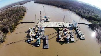
Yes the barge sits on the bottom and they might pile up limestone or concrete on top of it as well. It is definitely a dam that should not allow water over the top. Those channels are usually pretty shallow in places, sometimes less than 5 or 6 feet. I just checked my Garmin chartplotter software and it says the bayou chene at this point is "dredged to 6 feet", so there it is. Should be about 6' in depth, no problem for that barge to dam up.
Posted on 5/30/19 at 12:20 pm to WizardSleeve
Okay, then I was severely overestimating the depth of the channel. Thanks, guys.

Posted on 5/30/19 at 12:23 pm to TigerstuckinMS
This is from last time but it should be pretty much the same this time around.

You're right that's it basically just a dam that prevents backwater flooding of the area east of Morgan City.
You're right that's it basically just a dam that prevents backwater flooding of the area east of Morgan City.
Posted on 5/30/19 at 12:24 pm to TigerstuckinMS
quote:
I don't understand this, either. Can someone please fill me in. Use small words, too, because I'm kinda stupid.
I have this mental picture of a barge sitting at the bottom of the channel with water just going over it. Is that picture wrong? Is the barge that much taller than the depth of the channel that it'll essentially just be a dam?
They drive sheet pile on the sides and around the barge after they sink it
Here are some pictures from 2011 and 2016 when they did it


Posted on 5/30/19 at 12:26 pm to TigerstuckinMS
quote:
Okay, then I was severely overestimating the depth of the channel. Thanks, guys.
The barge they are using is 20' deep

Posted on 5/30/19 at 3:54 pm to tgrbaitn08
LINK
Opening has been delayed until June 6th. Apparently there are complications with the river forecast.
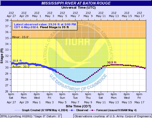
June 6th is just as the levels start to creep back up again.
Opening has been delayed until June 6th. Apparently there are complications with the river forecast.
June 6th is just as the levels start to creep back up again.
This post was edited on 5/30/19 at 4:15 pm
Posted on 5/30/19 at 3:58 pm to TDsngumbo
Fa why?
Posted on 5/30/19 at 4:01 pm to Teddy1388
Someone couldn't get their cattle out in time and another farmer needed extra time to haul out his crop.
Posted on 5/30/19 at 4:02 pm to Teddy1388
The article doesn't say. It's very weird.
Posted on 5/30/19 at 4:10 pm to TDsngumbo
Maybe the COE is stalling hoping to not have to open the spillway
Posted on 5/30/19 at 4:12 pm to jlntiger
quote:
UPDATE: The U.S. Army Corps of Engineers announced Thursday it has delayed the slow opening of the Morganza Spillway to Thursday, June 6 with a full opening June 9. The Corps said the delay is due to complications related to the river forecast.
LINK
This post was edited on 5/30/19 at 4:13 pm
Posted on 5/30/19 at 4:13 pm to MrPappagiorgio
Posted on 5/30/19 at 4:16 pm to MrPappagiorgio
date seems to coincide with river getting above 44' in BR
EDIT:
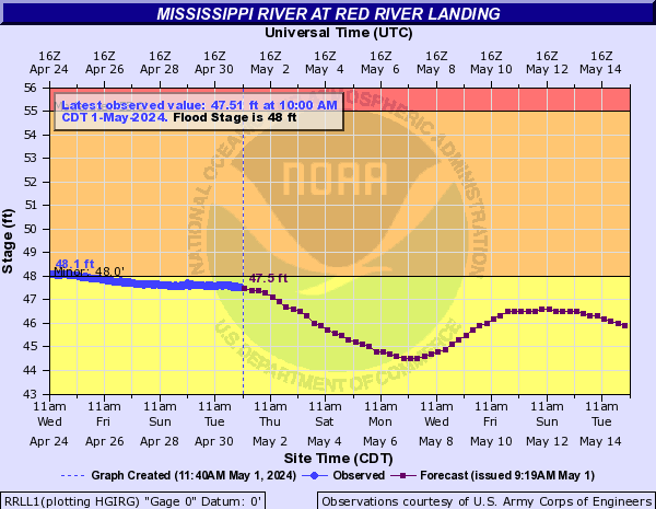
also date it crests at Red River Landing
This post was edited on 5/30/19 at 4:17 pm

Posted on 5/30/19 at 4:17 pm to tigeraddict
By LSU
Water is getting pretty high outchea


Water is getting pretty high outchea
This post was edited on 5/30/19 at 4:19 pm
Posted on 5/30/19 at 4:17 pm to TDsngumbo
Facebook Video link to St. Mary Levee District
animated graphic that shows where the barge is located in Bayou Chene and what are will be impacted (benefit) from stopping the water at that point.
animated graphic that shows where the barge is located in Bayou Chene and what are will be impacted (benefit) from stopping the water at that point.
Posted on 5/30/19 at 4:19 pm to LaBR4
quote:
By LSU
Water is getting pretty high outchea
Not one comment about your photo and the seepage taking place on the outside of the levee? U c dat dere black strip linin da rode dat be called seepage.

 Page 80 of 107

Back to top