- My Forums
- Tiger Rant
- LSU Recruiting
- SEC Rant
- Saints Talk
- Pelicans Talk
- More Sports Board
- Fantasy Sports
- Golf Board
- Soccer Board
- O-T Lounge
- Tech Board
- Home/Garden Board
- Outdoor Board
- Health/Fitness Board
- Movie/TV Board
- Book Board
- Music Board
- Political Talk
- Money Talk
- Fark Board
- Gaming Board
- Travel Board
- Food/Drink Board
- Ticket Exchange
- TD Help Board
Customize My Forums- View All Forums
- Show Left Links
- Topic Sort Options
- Trending Topics
- Recent Topics
- Active Topics
Started By
Message
re: Let's Do It Again: Severe Threat 3/30 - Line of Severe Storms leaving SELA. AL in it now
Posted on 3/28/22 at 5:01 pm to LegendInMyMind

Posted on 3/28/22 at 5:01 pm to LegendInMyMind
App is showing heavy window tomorrow (no surprise there) but no rain. Will this be individual cells firing off or should we expect a line to move through?
 1
1

Posted on 3/28/22 at 5:22 pm to LSUGrrrl
You will actually have a chance to see both.
Posted on 3/28/22 at 5:23 pm to LegendInMyMind
Yay?
Posted on 3/28/22 at 5:25 pm to LSUGrrrl
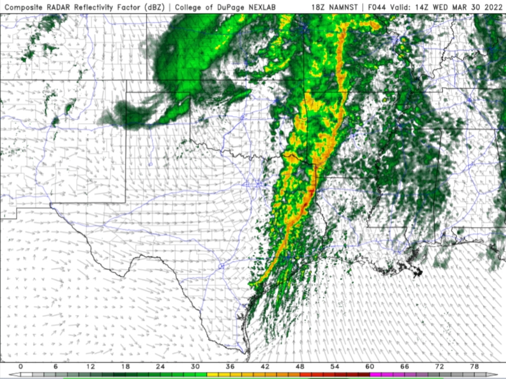
I went to Hattiesburg and Laurel last week. I have to say that although I didn’t see much the atmosphere was definitely juiced up. I would see dark clouds in areas of rotation, heavy rain, and then sunshine all in a matter of minutes. It was incredible
Posted on 3/28/22 at 5:27 pm to schwartzy
That's definitely an interesting look heading into MS. The 18z-21z window could get hairy.
This post was edited on 3/28/22 at 5:30 pm
Posted on 3/28/22 at 5:27 pm to LegendInMyMind
Do we expect much discrete cell action again at this time?
Posted on 3/28/22 at 5:27 pm to schwartzy
quote:
much the atmosphere was definitely juiced up
And it is "just March".
Posted on 3/28/22 at 5:29 pm to schwartzy
quote:
Do we expect much discrete cell action again at this time?
A broken line looks to be the more likely scenario. But the farther North you go into MS, the chance for some discrete development gets better.
Posted on 3/28/22 at 5:35 pm to schwartzy
quote:
Do we expect much discrete cell action again at this time?
Not as much as was expected last go round, though breaks in the line could let some individual cells get working.
Posted on 3/28/22 at 5:46 pm to LegendInMyMind
Are you able to choose the time on that radar? What's it look like if you roll it back say 4 hours

Posted on 3/28/22 at 5:48 pm to Sao

Posted on 3/28/22 at 5:49 pm to Sao
quote:
Are you able to choose the time on that radar? What's it look like if you roll it back say 4 hours
Posted on 3/28/22 at 6:00 pm to LegendInMyMind
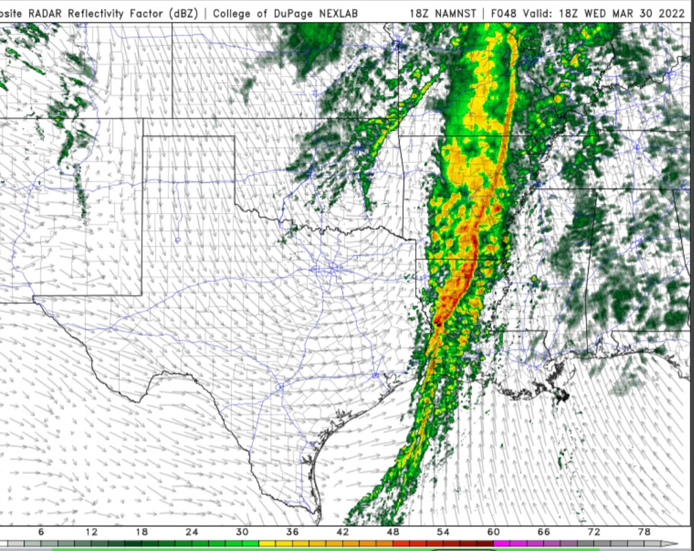
I again want to hit on the winds ahead of the line. They could well knock out power without any storms happening. They gonna be ripping on Wednesday, and if any of the winds above the ground get mixing due to sunshine mixing the boundary layer...could be getting 50+ mph gusts.
Don't be surprised by this.
Don't be surprised by this.
Posted on 3/28/22 at 6:03 pm to Duke
Yeah, the wind gust map is nasty. Some 60s showing up ahead of the line and they last until it progresses well into AL.
Posted on 3/28/22 at 6:05 pm to Duke
And, as if they were waiting for the perfect timing of your post:
@NWSHuntsville
@NWSHuntsville
quote:
5 Day Outlook: Warm weather will continue Tue-Wed. Very windy conditions on Wed w/gusts of 35-50 mph possible. Then, a strong cold front will bring a line of thunderstorms through the area late Wed afternoon/evening with damaging winds possible. #HUNwx LINK
This post was edited on 3/28/22 at 6:07 pm
Posted on 3/28/22 at 6:40 pm to Duke
let's not forget the NOLA tornado was in the slight risk area last week, don't be complacent because you aren't in the middle of the bullseye
Posted on 3/28/22 at 8:55 pm to DVinBR
quote:
don't be complacent
With 3 severe threats within a 12 day window and the first 2 not really matriculating in BR, people I talk to aren’t really taking this one serious. Hopefully the big story is just some wind down here
Posted on 3/28/22 at 9:32 pm to trussthetruzz
quote:
With 3 severe threats within a 12 day window and the first 2 not really matriculating in BR, people I talk to aren’t really taking this one serious. Hopefully the big story is just some wind down here
That's not shocking, and this one at least should have a lower ceiling.
Of course, straight line wind threats tend to be more widespread in impacts but the risk of the really high winds is going to be maximized a little further north.
Posted on 3/28/22 at 10:17 pm to Duke
A side question about the SPC. Why do they typically only issue one update a day and why is it usually released in the middle of the night?
Posted on 3/28/22 at 10:22 pm to East Coast Band
quote:
Why do they typically only issue one update a day and why is it usually released in the middle of the night?
IDK.
I kind of understand one update a day before Day 1. There's not a lot of significant changes in the synoptic scale stuff at this point and you dont really trust the high res stuff until youre in that 24 hour window and get some confirmation the initial conditions are good.
But...
730z is such a weird release time. That I have no idea the why.

 Page 4 of 92

Popular
Back to top