- My Forums
- Tiger Rant
- LSU Recruiting
- SEC Rant
- Saints Talk
- Pelicans Talk
- More Sports Board
- Coaching Changes
- Fantasy Sports
- Golf Board
- Soccer Board
- O-T Lounge
- Tech Board
- Home/Garden Board
- Outdoor Board
- Health/Fitness Board
- Movie/TV Board
- Book Board
- Music Board
- Political Talk
- Money Talk
- Fark Board
- Gaming Board
- Travel Board
- Food/Drink Board
- Ticket Exchange
- TD Help Board
Customize My Forums- View All Forums
- Show Left Links
- Topic Sort Options
- Trending Topics
- Recent Topics
- Active Topics
Started By
Message
re: Let's Do It Again: Severe Threat 3/30 - Line of Severe Storms leaving SELA. AL in it now
Posted on 3/29/22 at 12:32 pm to paperwasp

Posted on 3/29/22 at 12:32 pm to paperwasp
quote:
Your blog reminds me of a similar site called Storm Hamster. Same guy went by @crankywxguy on the twatters.
I used to follow this guy too until he disappeared. He did NOT like local weathermen hyping shite up
 1
1

Posted on 3/29/22 at 12:36 pm to Ingeniero
To a fault.
He was/is a wind speed truther on hurricanes. Which, at times, he had a point but I remember a few obvious major hurricanes he would argue were much weaker.
Like questioning if Michael was a hurricane when it had a clear eye right off the coast.
His methods of forecasting are... unique but his style of drawing up on images I certainly took as some inspiration.
Posted on 3/29/22 at 12:37 pm to Duke
quote:
Im sure, especially after last week. This time of year is awesome in Louisiana but I also could do without the weekly severe weather rounds.
Thankfully we had no issue, but we know plenty of people who were impacted terribly, including the family of the young man who perished.
It's a hell of a situation when the principal of Chalmette HS, who has been principal for 50 years, breaks down when being interviewed about the young man.
I know people say when it's your time to go, that's it... but it's hard to understand.
Posted on 3/29/22 at 1:01 pm to T
quote:
Too many severe thunderstorm warnings get issued
I mean they have the the 58 mph + standard they follow, it’s not supposed to be arbitrary at all
Maybe that standard should be raised I’m not the guy to ask but it’s not like it’s a judgement call

Posted on 3/29/22 at 1:05 pm to Wishnitwas1998

Posted on 3/29/22 at 1:08 pm to paperwasp
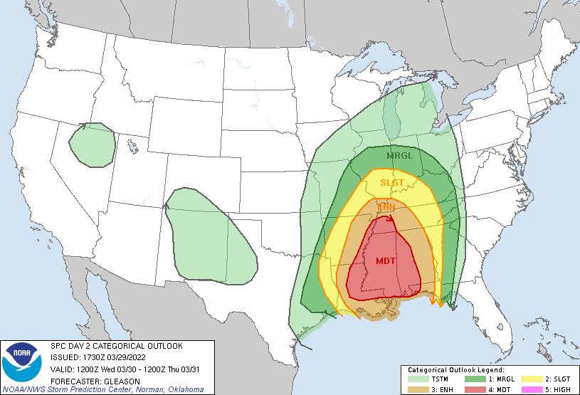
That is a huge moderate risk area.
This post was edited on 3/29/22 at 1:08 pm
Posted on 3/29/22 at 1:08 pm to paperwasp
It kinda looks like one of those Russian nesting dolls

Posted on 3/29/22 at 1:08 pm to Duke
DFW still looking scary overnight? Alerts tell me hail, damaging winds and tornadoes but hoping the timing knocks at least the tornadoes out while we are sleeping.
Posted on 3/29/22 at 1:09 pm to Roll Tide Ravens
All for the wind.
Posted on 3/29/22 at 1:09 pm to Roll Tide Ravens
I wonder what the chances are that we see a severe wind risk driven high risk for tomorrow? Those are pretty rare.
Posted on 3/29/22 at 1:09 pm to Duke
quote:
his style of drawing up on images I certainly took as some inspiration
Honestly, I thought that was the best part of his content too.
Great idea to use a similar style, IMO.
Posted on 3/29/22 at 1:11 pm to paperwasp
Not sure I've ever seen an entire state engulfed in the mod zone
Posted on 3/29/22 at 1:13 pm to trussthetruzz
quote:
Not sure I've ever seen an entire state engulfed in the mod zone
Certainly looks bizarre.
Posted on 3/29/22 at 1:14 pm to LSUGrrrl
quote:
DFW still looking scary overnight? Alerts tell me hail, damaging winds and tornadoes but hoping the timing knocks at least the tornadoes out while we are sleeping.
Its more limited in terms of extent but yeah all of it is possible. It should be getting ready to line up, so more of a wind threat with some quick spin ups.
Posted on 3/29/22 at 1:20 pm to Duke
quote:
It should be getting ready to line up
Timeline on that?
Posted on 3/29/22 at 1:22 pm to LSUGrrrl
2am to 5am for Metroplex
Posted on 3/29/22 at 1:23 pm to LegendInMyMind
quote:
This is a relatively new site/project that has done a really good job. They have taken on the task of documenting all tornadoes that they possibly can, and it is searchable with a map. They've even done pre-1950.
Somebody (possibly you?) may have linked it the other day but I think I stumbled onto it googling, it’s cool as shite
Posted on 3/29/22 at 1:24 pm to LegendInMyMind
quote:
I'm looking here for AL to see the highest potential for discrete. Everything comes together in that area for a couple hours.
Nailed it, Legend.
quote:
SPC AC 291730
Day 2 Convective Outlook
NWS Storm Prediction Center Norman OK
1230 PM CDT Tue Mar 29 2022
Valid 301200Z - 311200Z
The potential for supercells to develop ahead of the line, or perhaps embedded within the line with southward extent, remains unclear. Any cells that can form ahead of the line would be favored to produce tornadoes, but the quick eastward progression of the QCLS may limit this possibility. Still, some guidance suggests the southern part of the line may become more broken with time Wednesday afternoon/evening. If this occurs, then a threat for embedded supercells capable of producing multiple strong (EF2+) tornadoes would exist. At this point, the greatest tornado potential may focus along southern portions of the line in MS/AL where a semi-discrete mode seems more plausible. Regardless, a continued threat for both damaging winds and tornadoes will likely persist Wednesday evening and overnight as convection spreads from the lower MS Valley into the TN Valley and Deep South.
Posted on 3/29/22 at 1:30 pm to paperwasp
quote:quote:
Not sure I've ever seen an entire state engulfed in the mod zone
Certainly looks bizarre.
I thought it was an avocado
and now I want some guacamole

Posted on 3/29/22 at 1:32 pm to LSUFanHouston
quote:
Thankfully we had no issue, but we know plenty of people who were impacted terribly, including the family of the young man who perished.
It's a hell of a situation when the principal of Chalmette HS, who has been principal for 50 years, breaks down when being interviewed about the young man.
I know people say when it's your time to go, that's it... but it's hard to understand.
It was terrible to hear that the young man passed. Thankfully most of the people I know had minimal damage with no injuries.

 Page 10 of 92

Popular
Back to top