- My Forums
- Tiger Rant
- LSU Recruiting
- SEC Rant
- Saints Talk
- Pelicans Talk
- More Sports Board
- Coaching Changes
- Fantasy Sports
- Golf Board
- Soccer Board
- O-T Lounge
- Tech Board
- Home/Garden Board
- Outdoor Board
- Health/Fitness Board
- Movie/TV Board
- Book Board
- Music Board
- Political Talk
- Money Talk
- Fark Board
- Gaming Board
- Travel Board
- Food/Drink Board
- Ticket Exchange
- TD Help Board
Customize My Forums- View All Forums
- Show Left Links
- Topic Sort Options
- Trending Topics
- Recent Topics
- Active Topics
Started By
Message
re: Largest Dam in the Country at risk to fail EDIT- no immediate danger
Posted on 2/12/17 at 9:59 pm to HailHailtoMichigan!

Posted on 2/12/17 at 9:59 pm to HailHailtoMichigan!
Falling water levels aren't always a good thing, that water has to go somewhere.
 0
0

Posted on 2/12/17 at 10:01 pm to Thib-a-doe Tiger
I'd like to see pictures from those bridges in orroville for the last 4 hours.

Posted on 2/12/17 at 10:01 pm to Thib-a-doe Tiger
quote:Ilived in the area,, might know of placenames
68 miles south of that dam, dumbass
Posted on 2/12/17 at 10:02 pm to Crow Pie
This is probably just the beginning of issues in Cali as the wet weather should continue for a good while. There has been a lot of chatter about the permanent drought in Cali, esp. after last years El Nino failed to deliver big time rains that are typically associated with El Nino:

Once La Nina set in, things did not look good for drought recovery based on Cali getting about avg rainfall during a La Nina:

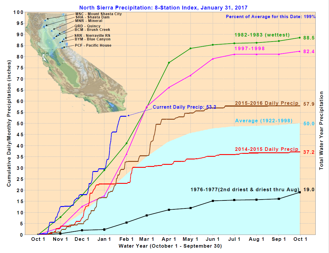
However, this La Nina has been kind of tricky given that some things have been more El Nino acting like the +PDO and +QBO. Cali has traditionally been pretty wet during +PDO/+QBO years but most of those years are also El Nino years. So this is a bit of an odd year and North Sierra Precipitation index is on pace for the wettest year ever!
Anyway, more rain on the way over the next two weeks with some areas possibly seeing over a foot of liquid equivalent:

Beyond that, the Pacific appears to beginning the process of shifting back towards El Nino and Cali should stay wet over the next few months.
Once La Nina set in, things did not look good for drought recovery based on Cali getting about avg rainfall during a La Nina:
However, this La Nina has been kind of tricky given that some things have been more El Nino acting like the +PDO and +QBO. Cali has traditionally been pretty wet during +PDO/+QBO years but most of those years are also El Nino years. So this is a bit of an odd year and North Sierra Precipitation index is on pace for the wettest year ever!
Anyway, more rain on the way over the next two weeks with some areas possibly seeing over a foot of liquid equivalent:
Beyond that, the Pacific appears to beginning the process of shifting back towards El Nino and Cali should stay wet over the next few months.
Posted on 2/12/17 at 10:06 pm to wheelr
quote:
The spillway failure could be due to a lack of inspection and preventive maintenance.
It seems to me that the emergency spillway should have been built with some type of concrete apron to prevent scour occurring right at the dam(n) wall. It wouldn't have had to extend as far as the original spillway.
20 bucks says that there was some stupid environmental regulation from the spillway being built properly.
Posted on 2/12/17 at 10:07 pm to rds dc
And you have the snow melt starting mid march
Posted on 2/12/17 at 10:09 pm to ItTakesAThief
quote:
ItTakesAThief
quote:
From Yosemite to Mt Whitney.
You hike the JMT? I'm hoping to get there in Aug/Sep if the permits work out.

Posted on 2/12/17 at 10:15 pm to AZTarheeel

Posted on 2/12/17 at 10:23 pm to ItTakesAThief
quote:
And you have the snow melt starting mid march
Some areas are running 200% above normal for snow pack.

Posted on 2/12/17 at 10:23 pm to LSUGrad9295
Lake level - 901.02
Slowly going down now
Slowly going down now
Posted on 2/12/17 at 10:26 pm to SDTiger15
Quote: //Hey... at least we are getting a high-speed rail that nobody will ride and takes you to the middle of nowhere. And it significantly over budget already. //
They ( State of Cali) brought my neighbor and his family over here from the U.K. To work on the high speed rail---such a waste of money!!!
They ( State of Cali) brought my neighbor and his family over here from the U.K. To work on the high speed rail---such a waste of money!!!
Posted on 2/12/17 at 10:28 pm to TigerTatorTots
quote:great news.
Lake level - 901.02
Slowly going down now
CNN reporting the concern seems to have died down.
Posted on 2/12/17 at 10:33 pm to CaliforniaTiger
Where you at California tiger? I'm in Plumas lake 
Posted on 2/12/17 at 10:35 pm to OWLFAN86
I'm in Roseville
Posted on 2/12/17 at 10:36 pm to LSUIZSEC
Are you evacuating?
Posted on 2/12/17 at 10:37 pm to AZTarheeel
Yeah I have hiked the JMT twice and backpacked all around the sierras hiking various loops.
If you can't get a Yosemite permit shoot for the Rush Creek Trail at June Lake. Ifbyou watch closely you can sometimes get a permit accessing there You will access the JMT just before Thousand Island Lakes. Rush creek trail sucks but once you are on the JMT it's fine.
Looks like the access road to Whitney Portal was taken out in a major rockslide this year so it may be mid to late summer before it is reopened depending on what it takes to clear and repair it.
Posted on 2/12/17 at 10:38 pm to CaliforniaTiger
70 is jammed up. I tried 5 but no go. Everyone from yuba to olivehurst sitting in traffic.
Posted on 2/12/17 at 10:40 pm to CaliforniaTiger
Beale AFB opened its gates for military but that sits just as low as Marysville.
Posted on 2/12/17 at 10:41 pm to LSUIZSEC
Are you in the military? Good luck to you LSUIZSEC
This post was edited on 2/12/17 at 10:43 pm
Posted on 2/12/17 at 10:42 pm to LSUIZSEC
Just saw on a stream that the areas under a flash flood wash til 4:15 (AM?) Monday went a bit south of Gridley.
Also, lights on the dam went out a few minutes ago. Newscasters have no idea if that is good or bad news.
4 inches dropped in the last hour. Just below lip of auxiliary spillway.
Also, lights on the dam went out a few minutes ago. Newscasters have no idea if that is good or bad news.
4 inches dropped in the last hour. Just below lip of auxiliary spillway.

 Page 7 of 20

Popular
Back to top