- My Forums
- Tiger Rant
- LSU Recruiting
- SEC Rant
- Saints Talk
- Pelicans Talk
- More Sports Board
- Coaching Changes
- Fantasy Sports
- Golf Board
- Soccer Board
- O-T Lounge
- Tech Board
- Home/Garden Board
- Outdoor Board
- Health/Fitness Board
- Movie/TV Board
- Book Board
- Music Board
- Political Talk
- Money Talk
- Fark Board
- Gaming Board
- Travel Board
- Food/Drink Board
- Ticket Exchange
- TD Help Board
Customize My Forums- View All Forums
- Show Left Links
- Topic Sort Options
- Trending Topics
- Recent Topics
- Active Topics
Started By
Message
re: Ian Observation Thread (Storm Track and Radar inside)
Posted on 9/21/22 at 9:00 pm to Jim Rockford
Posted on 9/21/22 at 9:00 pm to Jim Rockford
Bet that wasn’t fun
Bright side is there’s not as much shite to fly through the air
Bright side is there’s not as much shite to fly through the air
 0
0

Posted on 9/21/22 at 9:00 pm to gaetti15
quote:
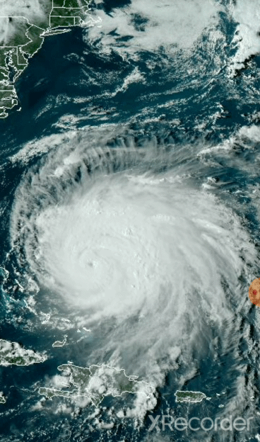
outflow super impressive
Yeah, that's upper level water vapor. You can see the shear that 98L is dealing with in the NE to SW motion across the area it is developing in.
Posted on 9/21/22 at 9:02 pm to catholictigerfan
Which seems to not agree with how aggressive GFS was or has been especially yesterday. GFS had something forming today and obviously that never happened. Duke said earlier Euro is more believable and that's probably true because the storm is showing no signs of getting together so that northern track is believable as it drifts NW. Stronger would probably be further south when it gets its act together.
Fiona is bitch slapping this storm. I wonder if it's possible this storm can slam into Nicaragua.
Fiona is bitch slapping this storm. I wonder if it's possible this storm can slam into Nicaragua.
This post was edited on 9/21/22 at 9:04 pm
Posted on 9/21/22 at 9:03 pm to LegendInMyMind
looks like intensity models have settled down a bit...besides CTCI which is predicting a west Pacific typhoon
Posted on 9/21/22 at 9:04 pm to Tiger 79
quote:
a mountain top 12 clicks from the DMZ in 1961.
Thanks. I was a 2nd lieutenant at the time. I was on that mountain during the Cuban Missile Crises. Things got sort of exciting.
This post was edited on 9/22/22 at 4:16 am
Posted on 9/21/22 at 9:05 pm to deuce985
quote:
Which seems to not agree with how aggressive GFS was or has been especially yesterday. GFS had something forming today and obviously that never happened. Duke said earlier Euro is more believable and that's probably true because the storm is showing no signs of getting together so that northern track is believable as it drifts NW. Stronger would probably be further south when it gets its act together.
Still to early to tell where this thing will go but I would guess that the GFS will be more west than it actually will be. But who knows.

Posted on 9/21/22 at 9:08 pm to catholictigerfan
I just don’t see it, too much shear there.

Posted on 9/21/22 at 9:12 pm to LegendInMyMind
quote:
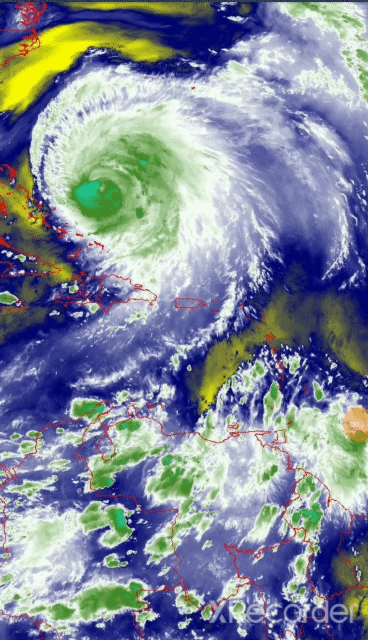
The big picture

Posted on 9/21/22 at 9:13 pm to Oates Mustache
Are the damn gifs small again? Dammit....I don't know why it does that! They actually look like they are supposed to when I post them, and even when I view them.

Posted on 9/21/22 at 9:14 pm to LegendInMyMind
That’s a bad arse bitch.
Posted on 9/21/22 at 9:14 pm to LegendInMyMind
The Big Picture one is small. the sun setting on Fiona is good for me.
Posted on 9/21/22 at 9:15 pm to LegendInMyMind
Not as pretty though
This post was edited on 9/21/22 at 9:16 pm
Posted on 9/21/22 at 9:16 pm to deuce985
quote:
Duke said earlier Euro is more believable and that's probably true because the storm is showing no signs of getting together so that northern track is believable as it drifts NW. Stronger would probably be further south when it gets its act together.
There is a bit of an upper level low in the NW Caribbean that is mostly to blame for the Euro picking up on a more abrupt Northern turn, and a more Northern track. The flow from that ULL helps to drag the system more North.
It doesn't seem that the GFS is picking up on, or valuing the strength of, that feature at this point.
Posted on 9/21/22 at 9:16 pm to fightin tigers
quote:
Not as pretty though
I can't figure out out to make them bigger. I even tried rubbing on them.
Posted on 9/21/22 at 9:18 pm to LegendInMyMind
quote:
It doesn't seem that the GFS is picking up on, or valuing the strength of, that feature at this point.
Wrll it better hurry the frick up

Posted on 9/21/22 at 9:21 pm to maisweh
quote:
NWS New Orleans
@NWSNewOrleans
Trust us, we get the anxiety people are feeling. Please do not panic or listen to the hype of social "mediarologists". Listen to trusted sources like us, NHC, or respected TV mets. We will let you know when there could be impacts for our area. For now, enjoy the sunny weather!

Posted on 9/21/22 at 9:21 pm to maisweh
It also matters that the longer 98L takes to close off the less it "feels" that pull. GFS could be picking up on the system not getting itself together quick enough. Though, the GFS and Euro have similar strength and vorticity signatures for the immediate future, so I don't know.
This post was edited on 9/21/22 at 9:31 pm

Posted on 9/21/22 at 9:22 pm to LegendInMyMind
The GFS also seems to have a way weaker front than the Euro
Posted on 9/21/22 at 9:23 pm to OmniPundit
quote:
…12 clicks from the DMZ in 1971.
Army? 1st Bde, 5th Inf Div (Mechanized)? Quang Tri? Cam Lo? Dong Ha?

 Page 59 of 465

Popular
Back to top