- My Forums
- Tiger Rant
- LSU Recruiting
- SEC Rant
- Saints Talk
- Pelicans Talk
- More Sports Board
- Fantasy Sports
- Golf Board
- Soccer Board
- O-T Lounge
- Tech Board
- Home/Garden Board
- Outdoor Board
- Health/Fitness Board
- Movie/TV Board
- Book Board
- Music Board
- Political Talk
- Money Talk
- Fark Board
- Gaming Board
- Travel Board
- Food/Drink Board
- Ticket Exchange
- TD Help Board
Customize My Forums- View All Forums
- Show Left Links
- Topic Sort Options
- Trending Topics
- Recent Topics
- Active Topics
Started By
Message


 1
1

Posted on 7/12/25 at 10:28 pm to Cosmo
Just in time for my GoA beach trip 
Posted on 7/12/25 at 10:46 pm to rds dc
0z icon showing even more strengthening in north central gulf.
not liking this trend
not liking this trend
Posted on 7/13/25 at 5:45 am to CoonassatTEXAS
quote:
0z icon showing
Icon is always bullish on development.
Let me know when we get to the Invest stage.
Otherwise it is business as usual.
This post was edited on 7/13/25 at 5:56 am
Posted on 7/13/25 at 5:56 am to rds dc
quote:
Posted by rds dc 6/28/25
quote:
This post was edited on 7/12/25 at 12:50 pm
Everyone and myself included love your posts and insight. But why do you edit old posts instead of starting new ones for new systems or potential systems?
Just curious. And thanks, as always.
Edit:
We’re all very thankful for your services. Make no mistake. Most of us really value your info and updates. But it’s buried with pages of posts that are weeks old and irrelevant and always making the same breast milk jokes.
This post was edited on 7/13/25 at 6:04 am

Posted on 7/13/25 at 6:58 am to rds dc
I have to drive to mobile for work on Wednesday and am coming back on Thursday. For that reason there will 100% be some kind of shitty torrential rain. I’m sorry yall.

Posted on 7/13/25 at 8:28 am to Tarps99
quote:
Icon is always bullish on development.
The ICON does get it right from the start from time to time and others start following suit eventually. I see it happen once every few years or so.
Oh no, now I’ve done it. Hey HoldThatTiger, I’m just speaking from my own personal observations over the years so please don’t confuse me with an expert in a weather thread.
Posted on 7/13/25 at 9:54 am to TDsngumbo
latest euro is starting to show a stronger storm as well
eastern texas though bama should start perking up
eastern texas though bama should start perking up
Posted on 7/13/25 at 10:54 am to CoonassatTEXAS
12z ICON still on its BS, stronger run than last time 968mb, just west of Sabine Pass.
Posted on 7/13/25 at 11:17 am to SWLA92
quote:
12z ICON still on its BS, stronger run than last time 968mb, just west of Sabine Pass.
The ICON is almost certainly wrong. It has a much stronger and organized 500mb vort off the East Coast of FL at 24 hours vs. the GFS & Euro.
12z ICON
vs.
12z GFS

This appears to be the result of intense convection that the ICON fires today. The longer-term impact of this is that the system becomes more organized as it moves west into the Gulf. The Euro and GFS are weaker and less organized, and this results in the system getting strung out and pushed onshore. The ICON is stronger and stays offshore for longer, allowing it to strengthen the system.
Posted on 7/13/25 at 11:24 am to rds dc
The voice of reason arrives
Unlike the slapdicks that pick the worst model like wishcaster twitter tards
Unlike the slapdicks that pick the worst model like wishcaster twitter tards
Posted on 7/13/25 at 11:31 am to Cosmo
quote:
The voice of reason arrives
With that said, there are some minor trends towards a named system on the 12z models. The ICON is a strong outlier, maybe a 20% type chance of verifying.
Posted on 7/13/25 at 11:32 am to Cosmo
Last I checked this was a message board so we will have discussions. There’s a few different models out there so they will be tossed around here for discussion. If you can’t handle discussion on different model runs don’t read them.
Posted on 7/13/25 at 11:56 am to Cosmo
quote:
Unlike the slapdicks that pick the worst model like wishcaster twitter tards
Here you go
This post was edited on 7/13/25 at 12:25 pm
Posted on 7/13/25 at 12:42 pm to rds dc
quote:
With that said, there are some minor trends towards a named system on the 12z models. The ICON is a strong outlier, maybe a 20% type chance of verifying.
12z Euro is coming in with a stronger vort at 500mb
Posted on 7/13/25 at 12:51 pm to Dtbtiger
The NWS does a fine job of reporting the weather conditions, both current and future, without interjecting any global warming bias.
This post was edited on 7/13/25 at 5:26 pm

Posted on 7/13/25 at 12:57 pm to Turnblad85
quote:
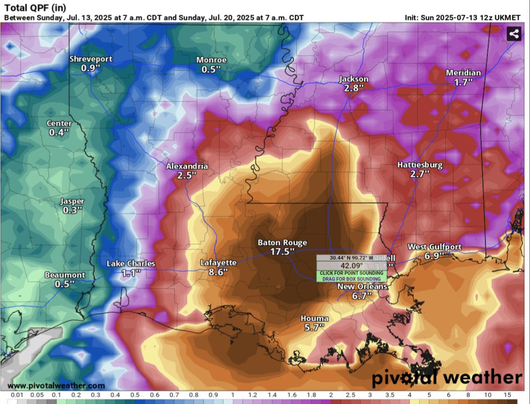
will be a 150 years before that happens in BR again.

Posted on 7/13/25 at 1:33 pm to rds dc
quote:
12z Euro is coming in with a stronger vort at 500mb
The end result is the same, with the system unable to consolidate before moving onshore. The ICON is still an outlier, but conditions are prime for intensification if the system consolidates faster, like the ICON shows.

Posted on 7/13/25 at 1:36 pm to habz007
quote:
But why do you edit old posts instead of starting new ones for new systems or potential systems?
Because he does it when it's a nasty threat, which this one isn't.

 Page 8 of 35

Popular
Back to top