- My Forums
- Tiger Rant
- LSU Recruiting
- SEC Rant
- Saints Talk
- Pelicans Talk
- More Sports Board
- Fantasy Sports
- Golf Board
- Soccer Board
- O-T Lounge
- Tech Board
- Home/Garden Board
- Outdoor Board
- Health/Fitness Board
- Movie/TV Board
- Book Board
- Music Board
- Political Talk
- Money Talk
- Fark Board
- Gaming Board
- Travel Board
- Food/Drink Board
- Ticket Exchange
- TD Help Board
Customize My Forums- View All Forums
- Show Left Links
- Topic Sort Options
- Trending Topics
- Recent Topics
- Active Topics
Started By
Message
 0
0

Posted on 6/2/19 at 8:20 pm to rds dc
Sunday 00z ( 7 pm CDT) INVEST 91L
20.0 N. 94.1 W.
Max winds (25 knots) ( 29 mph)
Central minimum pressure : 1007 mb (29.73 in Hg)
20.0 N. 94.1 W.
Max winds (25 knots) ( 29 mph)
Central minimum pressure : 1007 mb (29.73 in Hg)

Posted on 6/2/19 at 8:23 pm to Klingler7
I wouldn't mind 3-4 inches of rain. My yard is bone dry even with sprinklers

Posted on 6/3/19 at 6:10 am to rds dc
Well... the modeling on this one has sure turned to shite for Louisiana.
Posted on 6/3/19 at 6:39 am to udtiger
Looks like a few days of rain
Posted on 6/3/19 at 6:41 am to Riolobo
My yard needs it.
Posted on 6/3/19 at 7:15 am to WylieTiger
Frick
Guess we’ll have to move the Super Regional to the Superdome

Guess we’ll have to move the Super Regional to the Superdome

Posted on 6/3/19 at 8:17 am to PhillyTiger90
Space city weathers write up on it
quote:
Between now and Tuesday night, the tropical disturbance should follow a track to the northwest, toward Brownsville. But by Tuesday night or Wednesday morning, it should follow a more northerly or northeasterly path, likely along the Texas coast, or just offshore. For Texas’ rain chances, offshore would be better because it means reduced rainfall amounts. Beginning from Wednesday morning, rain chances will be higher in Houston, above 70 percent, and still higher on Thursday as the bulk of the disturbance moves near Houston. Tropical air masses are especially efficient at producing heavy rainfall, but again we’re hoping that the best conditions for heavy rain will set up offshore. If that happens, most of Houston should see 1 to 3 inches of rain through Thursday night, with potentially a few higher bullseyes of perhaps 5 inches of greater. If the tropical disturbance plows into Houston, rain totals will be greater, but for now we expect the former scenario. We’ll continue to watch this closely and apprise you of changes.
Posted on 6/3/19 at 8:25 am to rds dc
Bumping this because even though it would be a mid-level TS at the most by the time it got to LA, because of the situation with the Mississippi/Morganza, it bears attention.
Posted on 6/3/19 at 8:31 am to udtiger
quote:
Bumping this because even though it would be a mid-level TS at the most by the time it got to LA, because of the situation with the Mississippi/Morganza, it bears attention.
More likely to be weak at best and just a quick rainmaker. Shouldn't stick around too long, but is pumping moisture farther north where no one wants to see it.
I'm more worried the river could still be high going into the heart of hurricane season.
Posted on 6/3/19 at 9:09 am to Duke
quote:
More likely to be weak at best and just a quick rainmaker. Shouldn't stick around too long,
Thanks.
quote:
but is pumping moisture farther north where no one wants to see it.
Crap
quote:
I'm more worried the river could still be high going into the heart of hurricane season.
I don't think there's any way to avoid this unless we get a solid long arse stretch of dry weather over the MR valley.
Posted on 6/3/19 at 10:09 am to NorthEndZone
quote:
Something to keep half an eye on for now.
I can't cut my eye in half baw... I need all my eyes
Posted on 6/3/19 at 12:57 pm to rt3
Posted on 6/3/19 at 1:21 pm to WoWyHi
quote:
Most are saying 6" of rain at the peak, not exactly fitting of the word staggering. Looks like Ole Larry is looking for clicks.
6 inches of rain in the corn belt and south would be devastating with the already high rivers
Posted on 6/3/19 at 1:31 pm to rds dc
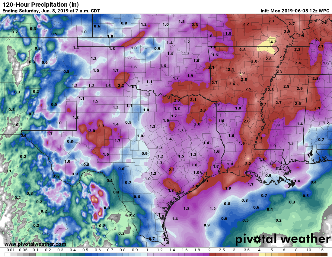
Some minor changes over the past 48hrs that might allow NHC to increase development chances upwards from 60% this evening or overnight. Overall, system is still disorganized and broad but a bit more organized than yesterday.

Even just 36hrs ago the system was still entangled with CA

The 12z GFS was initialized with the system a bit more consolidated in the BOC

While that is a bit more favorable for development both the 12z GFS (below) and Euro agree that a stout ridge over the Gulf will keep this close to the coast of Mexico.

Still not much of a threat but will eventually bring some rain up into SE TX and LA.
Even just 36hrs ago the system was still entangled with CA
The 12z GFS was initialized with the system a bit more consolidated in the BOC
While that is a bit more favorable for development both the 12z GFS (below) and Euro agree that a stout ridge over the Gulf will keep this close to the coast of Mexico.
Still not much of a threat but will eventually bring some rain up into SE TX and LA.

Posted on 6/3/19 at 3:46 pm to rds dc
Hopefully nothing too extended into the weekend.
Posted on 6/3/19 at 3:49 pm to BallsEleven
quote:
Hopefully nothing too extended into the weekend.
As of right now, Friday is probably the wettest day with Saturday and Sunday being kind of typical afternoon tstorm days across S. LA. Lsu should be able to get games in on Saturday, Sunday and Monday but Friday might be iffy.

Posted on 6/3/19 at 3:50 pm to rds dc
It gon rain. For the super regional.
Posted on 6/3/19 at 4:00 pm to rds dc
Wonder if it would be enough justification for them to make is a Sat-Mon series?
Posted on 6/4/19 at 6:23 am to BallsEleven
Any update?

 Page 4 of 29

Popular
Back to top