- My Forums
- Tiger Rant
- LSU Recruiting
- SEC Rant
- Saints Talk
- Pelicans Talk
- More Sports Board
- Coaching Changes
- Fantasy Sports
- Golf Board
- Soccer Board
- O-T Lounge
- Tech Board
- Home/Garden Board
- Outdoor Board
- Health/Fitness Board
- Movie/TV Board
- Book Board
- Music Board
- Political Talk
- Money Talk
- Fark Board
- Gaming Board
- Travel Board
- Food/Drink Board
- Ticket Exchange
- TD Help Board
Customize My Forums- View All Forums
- Show Left Links
- Topic Sort Options
- Trending Topics
- Recent Topics
- Active Topics
Started By
Message
 2
2

Posted on 10/4/17 at 9:27 pm to rds dc
Could one of you fine gents tell me what the scenerio would be for a mandatory evacuation of Orange Beach? And the likelihood of that happening? I just got here and don't mind sitting in the condo through shitty weather, but do not want to be sitting on I-10 Saturday.
This post was edited on 10/4/17 at 9:32 pm
Posted on 10/4/17 at 9:31 pm to Tigerbob75
From the looks of this storm, I doubt they’d even have a mandatory evac for a cat 1.

Posted on 10/4/17 at 9:33 pm to Tigerbob75
Cat 1 no mandatory evac
And if you are in a modern highrise you will be safe as can be
And if you are in a modern highrise you will be safe as can be
Posted on 10/4/17 at 9:38 pm to Tigerbob75
I doubt there are any major evacs. This storm could potentially get strong but right now nothing points to it being stronger than a cat 1-2.
Posted on 10/4/17 at 9:39 pm to Cosmo
I wondering why the lack of data gathering updates? With so many unknowns with this storm I figured they'd be constantly flying into it to see if it's strengthening or not
On radar it looks a bit more organized
On radar it looks a bit more organized
Posted on 10/4/17 at 9:47 pm to Large Farva
quote:
I'm sure you would. You fancy folk on the north shore have working pumps. Us south shore folk have not a clue if we even have pumps.
Come hang out with us rich folks above sea level along Magazine.
Posted on 10/4/17 at 9:49 pm to deltaland
Cat 2 will frick shite up. This shite scares me because people think it needs to be a 4 or 5 to haul arse.
Posted on 10/4/17 at 9:52 pm to the LSUSaint
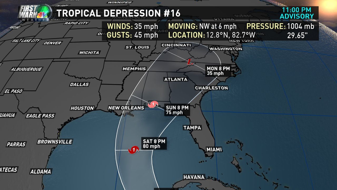
000
WTNT41 KNHC 050248
TCDAT1
Tropical Depression Sixteen Discussion Number 3
NWS National Hurricane Center Miami FL AL162017
1100 PM EDT Wed Oct 04 2017
There have been some structural changes to the depression during
the past few hours. Inner-core convection began developing just
after the issuance of the previous advisory, and Colombian radar
images from San Andres are now showing a well-defined convective
band to the east and southeast of the center. Despite these
changes, Dvorak satellite estimates remain T2.0 from TAFB and SAB,
so the initial intensity is held at 30 kt.
The depression probably only has another 12 hours or so before its
center moves inland over northeastern Nicaragua, but it is still
expected to reach tropical storm strength before that happens.
Once the center re-emerges over the waters of the northwestern
Caribbean Sea a little after 24 hours from now, high oceanic heat
content and low shear should contribute to strengthening. Despite
these favorable conditions, the amount of strengthening will be
unclear until we know how well the inner core survives crossing over
Nicaragua and Honduras. Strengthening is likely to continue
through at least day 3 up until the time the cyclone reaches the
central Gulf of Mexico. After day 3, there are some indications
that higher shear and/or cooler shelf waters over the northern Gulf
of Mexico could lead to some weakening, but that scenario is by no
means a definite one at this time. Needless to say, there continues
to be greater-than-normal uncertainty in the intensity forecast.
The updated NHC intensity forecast has been adjusted downward just
a bit through day 3 to follow an overall shift in the guidance,
although it should be noted that the official forecast still lies
above the normally skillful HCCA model.
If the intensity forecast is complex, the track forecast is not
much easier. For the first 48 hours, the models appear split on
how the depression will interact with a disturbance currently
located near the Straits of Florida. For example, the ECMWF model
shows some interaction with the disturbance's low-level vorticity,
which swings the depression more to the east on the right side of
the guidance envelope. The GFS, on the other hand, shows no such
interaction and has the cyclone on the western side of the guidance
envelope. This setup has significant downstream effects after 48
hours because it keeps the ECMWF on an eastern route and the GFS on
a western route as the cyclone heads toward the U.S. Gulf coast.
The new NHC track forecast has been shifted slightly westward,
although it is still not as far west as the consensus aids or the
HCCA model. Interestingly, although the ECMWF ensemble mean is
close to the operational run on the eastern side of the guidance
envelope, there is a high density of members to the left close to
the consensus aids, which lends additional support for the westward
adjustment.
A G-IV mission and Florida special soundings will begin tomorrow to
better determine the synoptic steering flow around the cyclone.
KEY MESSAGES:
1. The depression is forecast to strengthen and bring tropical storm
conditions to portions of Nicaragua and Honduras through early
Friday. Heavy rainfall could produce life-threatening flash
flooding and mud slides in portions of Nicaragua, Honduras, Costa
Rica, and Panama through Friday night.
2. The system could be near hurricane intensity when it approaches
the Yucatan Peninsula late Friday or Saturday, bringing direct
impacts from wind, storm surge, and heavy rainfall, and a hurricane
watch has been issued for a portion of this area.
3. The system is forecast to continue strengthening over the Gulf of
Mexico and could affect portions of the northern Gulf Coast as a
hurricane this weekend, with direct impacts from wind, storm surge,
and heavy rainfall. However, it is too early to specify the timing,
location, or magnitude of these impacts. Residents along the Gulf
Coast from Louisiana to Florida should monitor the progress of this
system for the next several days and heed any advice given by local
officials.
FORECAST POSITIONS AND MAX WINDS
INIT 05/0300Z 12.8N 82.7W 30 KT 35 MPH
12H 05/1200Z 13.5N 83.2W 35 KT 40 MPH
24H 06/0000Z 15.1N 83.7W 35 KT 40 MPH...INLAND
36H 06/1200Z 17.6N 84.7W 45 KT 50 MPH
48H 07/0000Z 20.2N 86.3W 55 KT 65 MPH
72H 08/0000Z 25.5N 88.6W 70 KT 80 MPH
96H 09/0000Z 30.5N 87.0W 65 KT 75 MPH...INLAND
120H 10/0000Z 36.5N 82.5W 30 KT 35 MPH...POST-TROP/INLAND
$$
Forecaster Berg
Still lots of uncertainty.
Posted on 10/4/17 at 9:53 pm to Large Farva

Posted on 10/4/17 at 9:54 pm to AU24


Posted on 10/4/17 at 10:02 pm to Fishwater
What's the upshot?
Posted on 10/4/17 at 10:03 pm to lsuman25
quote:
Tropical Depression Sixteen Discussion Number 3
NWS National Hurricane Center Miami FL AL162017
1100 PM EDT Wed Oct 04 2017
Westward shift from Apalachicola, FL this afternoon to Pensacola with this latest update.
Posted on 10/4/17 at 10:03 pm to AU24

Posted on 10/4/17 at 10:03 pm to fightin tigers
I'm actually staying across the street from Bruno's. We are high and dry here.

Posted on 10/4/17 at 10:05 pm to lsuwontonwrap
Pretty abrupt shift west.
Posted on 10/4/17 at 10:07 pm to udtiger
quote:
Pretty abrupt shift west.
hasn't it been edging west since this afternoon?

Posted on 10/4/17 at 10:08 pm to rds dc
Bermuda holding strong. What prevents is from strengthening overly much?

Posted on 10/4/17 at 10:08 pm to udtiger
You guys on Tiger Rant are god damn idiots for wishing this to hit Gainesville... it's moving closer and closer to hitting Louisiana instead.
Dumb is dumb.
This storm is so new though, tough to really know what it's going to do... could move north very slowly for all we know... but I do know it's going to interrupt LSU fans heading back from Gainesville.
Dumb is dumb.
This storm is so new though, tough to really know what it's going to do... could move north very slowly for all we know... but I do know it's going to interrupt LSU fans heading back from Gainesville.

 Page 28 of 193

Popular
Back to top