- My Forums
- Tiger Rant
- LSU Recruiting
- SEC Rant
- Saints Talk
- Pelicans Talk
- More Sports Board
- Coaching Changes
- Fantasy Sports
- Golf Board
- Soccer Board
- O-T Lounge
- Tech Board
- Home/Garden Board
- Outdoor Board
- Health/Fitness Board
- Movie/TV Board
- Book Board
- Music Board
- Political Talk
- Money Talk
- Fark Board
- Gaming Board
- Travel Board
- Food/Drink Board
- Ticket Exchange
- TD Help Board
Customize My Forums- View All Forums
- Show Left Links
- Topic Sort Options
- Trending Topics
- Recent Topics
- Active Topics
Started By
Message
re: Hurricane Maria - Visiting the Outer Banks before Moving OTS
Posted on 9/20/17 at 9:54 pm to Chad504boy
Posted on 9/20/17 at 9:54 pm to Chad504boy
quote:
Puerto Rico still getting hammered w back bands
Unlikely to let up either. Maria has had consistent strong bands far to the east of the circulation.
 2
2


Posted on 9/20/17 at 9:59 pm to slackster
Those poor folks. I can't imagine.

Posted on 9/20/17 at 10:16 pm to Hangit
Yes their place is on stilts, the bottom floor was all closed in though with a bedroom, bathroom, utility room, double car garage, etc. The surge totally took out everything in the bottom floor plus the metal building and the boat, the wind took the roof off on the north side so all the upper floor sustained water damage. Cellings and cabinets have caved in so it's a total loss, the pilings will be about the only thing left it sounds like. He did find 20 of his rods and reels across the road in a field buried under several inches of mud, only one rod was unbroke. Found the boat trailer under someones roof in the canal and the boat was 2 canals and 3 roads over all beat to hell and totalled. Crazy how fast things can change.
Posted on 9/20/17 at 10:32 pm to slackster

Eye yuuuge.

Posted on 9/20/17 at 10:33 pm to Duke
Duke, where do the noodle models have this one going after PR?
Posted on 9/20/17 at 10:39 pm to Rebel

Pretty strong agreement but what happens with Jose matters in terms of opening the door NE off the coast of the US.
Looks good so far, but wouldn't take it to the bank just yet.
Posted on 9/20/17 at 11:32 pm to Duke
This was from 13 hrs ago before the latest bands of heavy rain inundated the area even more.
This post was edited on 9/20/17 at 11:34 pm

Posted on 9/20/17 at 11:36 pm to ihometiger
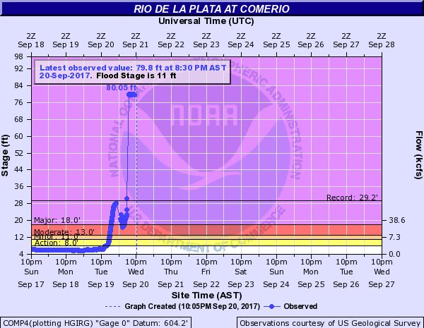
80 ft. How is that possible?
Posted on 9/20/17 at 11:38 pm to Cosmo
(no message)
This post was edited on 9/21/17 at 12:37 am
Posted on 9/21/17 at 12:35 am to ihometiger
FYI, that picture is from 2011 and Hurricane Irene.
ETA - It is highly unlikely the river has risen over 69 feet. The upstream and downstream gauges show significant rises, but nothing in the neighborhood of the flow shown in that graphic.
ETA - It is highly unlikely the river has risen over 69 feet. The upstream and downstream gauges show significant rises, but nothing in the neighborhood of the flow shown in that graphic.
This post was edited on 9/21/17 at 12:38 am
Posted on 9/21/17 at 1:07 am to slackster
quote:
that area clears out, Maria would have an eye that is nearly 80 miles across.
Forgive my ignorance but how big can an eye really get and maintain a powerful storm? I've ever really thought about it and have never heard of an eye being 80 miles across but that's prolly just my ignorance
Posted on 9/21/17 at 6:29 am to LakeViewLSU
quote:. I hope you are right. And while I agree that the culture is different, I'm not sure the net result will be better. But we will certainly soon find out as everyone's mettle and moral fortitude will be put to an extreme test in the next few months- year.
his isnt New Orleans we are talking about. I don't think it will come to that. The culture is different.
Posted on 9/21/17 at 6:52 am to Wishnitwas1998
quote:
Forgive my ignorance but how big can an eye really get and maintain a powerful storm? I've ever really thought about it and have never heard of an eye being 80 miles across but that's prolly just my ignorance
The eye was unlikely to be 80 miles across as the outer eye wall contracts around the inner eye wall, but Typhoon Carmen had an eye that was 200 miles across, the largest ever recorded.
My anecdotal evidence suggest that a smaller eye is associated with higher winds, but a very tight wind field, and is often unstable. Larger eyes tend to be more stable, but don't usually pack the same punch from a wind standpoint. However, they often have larger wind fields, which makes sense when the first 20+ miles form the center is still the relatively calm eye.

Posted on 9/21/17 at 7:21 am to slackster
Slack that graph's date is sept 20 2017
Posted on 9/21/17 at 8:05 am to 50_Tiger
quote:
Slack that graph's date is sept 20 2017
I understand the graph is current, but it's likely faulty.
The post to which I replied had a picture of the river and a dam, but that was from 2011.

Posted on 9/21/17 at 8:47 am to Duke
Green noodle projection must have taken into account Maria sucking up all the Bacardi in San Juan.
Posted on 9/21/17 at 8:50 am to slackster
Slack is correct the photos were incorrect. The 80 ft river surge was caused by a massive landslide below the dam which briefly clogged the river. Once the water reached eighty ft the pressure pushed the mud downstream and the water stabilized and dropped significantly. The landslides happened in several other rivers as well. The gauge wasn't faulty. We are talking about serious water and force that cleared out the landslide too.
Posted on 9/21/17 at 9:21 am to ihometiger
Any link to the mudslide ordeal? I looked last night but couldn't find anything.
Posted on 9/21/17 at 10:17 am to slackster
My buddy said the water was still coming up when he left his house since he didn't want to get stuck on the second floor.
Also by this morning most trees are gone and any smaller wooden houses are mostly gone.
Also by this morning most trees are gone and any smaller wooden houses are mostly gone.
Posted on 9/21/17 at 11:57 am to eng08
Pics from Puerto Rico
Here some pics and video is near bottom of page. The pic with all the pieces of wood/logs covering the street is crazy.
Here some pics and video is near bottom of page. The pic with all the pieces of wood/logs covering the street is crazy.

 Page 39 of 43

Popular
Back to top