- My Forums
- Tiger Rant
- LSU Recruiting
- SEC Rant
- Saints Talk
- Pelicans Talk
- More Sports Board
- Fantasy Sports
- Golf Board
- Soccer Board
- O-T Lounge
- Tech Board
- Home/Garden Board
- Outdoor Board
- Health/Fitness Board
- Movie/TV Board
- Book Board
- Music Board
- Political Talk
- Money Talk
- Fark Board
- Gaming Board
- Travel Board
- Food/Drink Board
- Ticket Exchange
- TD Help Board
Customize My Forums- View All Forums
- Show Left Links
- Topic Sort Options
- Trending Topics
- Recent Topics
- Active Topics
Started By
Message
re: Hurricane Irma - Spinning Down
Posted on 9/10/17 at 2:08 am to LSUGrrrl
Posted on 9/10/17 at 2:08 am to LSUGrrrl
quote:
LSUGrrrl
Irish Kevin probably made that playlist last week. I bet he's in Colorado now watching his live cam, drinking adult beverages, and reviewing his insurance policy.
I'm glued to it too.
 1
1

Posted on 9/10/17 at 2:09 am to Schmelly
At the florida keeeeeeeeys there's a massive hurricane called Irma
Posted on 9/10/17 at 2:09 am to Ed Osteen
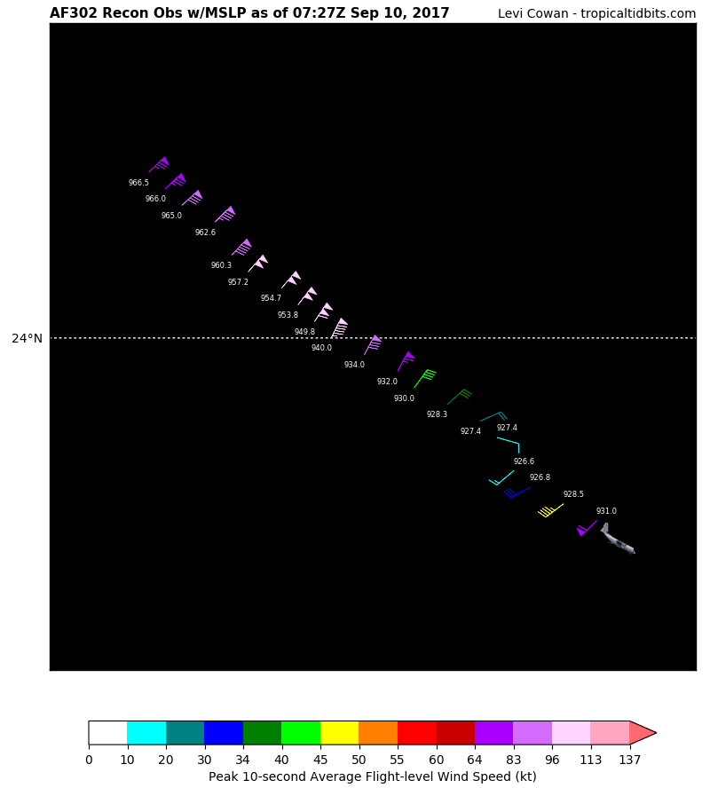
NW at 6 mph. That's pretty slow over hot water.
Posted on 9/10/17 at 2:12 am to DVinBR
Still think she's going to miss the peninsula?

Posted on 9/10/17 at 2:13 am to Sparkplug#1
The feeder bands are doing a number on Ft Pierce right now. Red cells are training from off shore heading west

Posted on 9/10/17 at 2:14 am to OKellsBells
Nah. He's there. He just walked out onto Duval St to check out the rain. You can see the streets are flooding a little.
Posted on 9/10/17 at 2:17 am to MrSmith
Yes

Posted on 9/10/17 at 2:18 am to LSUGrrrl
Didn't they run new models at 2am?
Any changes? Tampa/St Pete area still seem to be ground zero?
Any changes? Tampa/St Pete area still seem to be ground zero?
Posted on 9/10/17 at 2:18 am to Sparkplug#1
Waters boiling under her. Was it predicted Irma would go this slow into landfall ?
This post was edited on 9/10/17 at 2:19 am
Posted on 9/10/17 at 2:20 am to Rakim

Posted on 9/10/17 at 2:21 am to Rebel
LINK
quote:
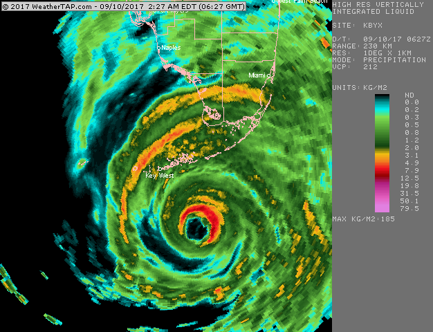
Early Sunday morning, Irma was approaching the Lower Florida Keys as an intensifying Category 4 storm with top sustained winds of 130 mph. Irma was finalizing an eyewall replacement cycle, with the previous concentric eyewalls from earlier Saturday now replaced by a single eyewall about 23 miles in diameter. With this cycle complete, further strengthening appeared likely for at least a few more hours, as Irma was traversing sea surface temperatures of 30° (86°F). Southwesterly winds at upper levels were helping to ventilate the storm. As Irma continues northwest, this increasing shear will begin to impede the intensification process and, together with land interaction, will eventually lead to weakening. Irma may reach the southwest coast of Florida on Sunday afternoon while still at Category 4 strength. Regardless of its peak winds at landfall, Irma poses an extremely serious storm-surge threat to the highly populated, surge-vulnerable stretch of coastline from Fort Myers to Tampa.
quote:
At 3:00 am EDT, Irma was located about 65 miles southeast of Key West, drifting northwest at 6 mph. Rainbands and squalls ahead of Irma’s core were lashing the Lower Keys early Sunday morning. Key West was experiencing a storm surge of about 1.5 feet, with winds at the airport gusting to 62 mph at 1:53 am EDT Sunday. Irma is likely to deliver a punishing storm surge and fierce winds to Key West and/or Big Piney Key on Sunday morning, with the eyewall heading for one or both islands. The predicted surge of 5 - 10 feet could arrive in two phases, affecting opposite sides of the islands, as winds shift during the passage of the hurricane.
quote:
The odds were increasing on Saturday night that Irma’s trek up the Florida peninsula would be focused along the state’s west coast. The NOAA/NWS National Hurricane Center again nudged its forecast track slightly westward at 11 pm EDT Saturday, bringing the center of the “cone of uncertainty” across the Tampa-St. Petersburg area for the first time. Guidance from the 12Z Saturday ensemble run of the European model, and from short-range models on Saturday night, suggested that Irma may stay near the west coast along the entire peninsula, perhaps remaining partly or even mostly offshore. Such a track would enhance the risk of damaging hurricane-force winds along the entire west coast, including the Tampa-St. Petersburg area. Winds to at least tropical storm strength (sustained at 39 mph)—perhaps lasting a few hours—are likely on Irma’s right-hand side across the entire Florida peninsula, as well as the eastern Panhandle and southern Georgia
quote:
The westward-trending track also raises concerns for the eastern Florida Panhandle, where a direct hurricane landfall would be possible if Irma stayed just off the state’s northwest coast. Hurricane Warnings extended late Saturday for the entire Florida coast from Indian Pass (including the Tallahassee area) around the peninsula to the Georgia border.
This post was edited on 9/10/17 at 2:24 am
Posted on 9/10/17 at 2:22 am to LSUGrrrl
Man, I can't say "wtf" on periscope? I'm in a 1 hour timeout cause some weirdo was dancing to "my pony".... in st. Pete. There's definitely some people who give no fricks that they're bout to die.

Posted on 9/10/17 at 2:24 am to Schmelly
Posted on 9/10/17 at 2:26 am to LSUGrrrl
Posted on 9/10/17 at 2:30 am to LSUGrrrl
youtube stream now playing kocomo, nothing like the beachboys before you float away 
Posted on 9/10/17 at 2:30 am to LSUGrrrl
Kokomo playingnow lol
Posted on 9/10/17 at 2:33 am to Schmelly
That water is rising up on the walkway now.
Posted on 9/10/17 at 2:34 am to LSUGrrrl
Posted on 9/10/17 at 2:36 am to LSUGrrrl
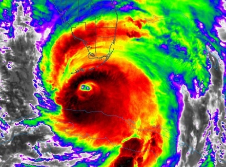
Is that a double eye?

 Page 614 of 711

Popular
Back to top