- My Forums
- Tiger Rant
- LSU Recruiting
- SEC Rant
- Saints Talk
- Pelicans Talk
- More Sports Board
- Coaching Changes
- Fantasy Sports
- Golf Board
- Soccer Board
- O-T Lounge
- Tech Board
- Home/Garden Board
- Outdoor Board
- Health/Fitness Board
- Movie/TV Board
- Book Board
- Music Board
- Political Talk
- Money Talk
- Fark Board
- Gaming Board
- Travel Board
- Food/Drink Board
- Ticket Exchange
- TD Help Board
Customize My Forums- View All Forums
- Show Left Links
- Topic Sort Options
- Trending Topics
- Recent Topics
- Active Topics
Started By
Message
re: Harvey ***Catastrophic Flooding Event***
Posted on 8/23/17 at 6:41 am to GEAUXmedic
Posted on 8/23/17 at 6:41 am to GEAUXmedic
Since none of these graphics show timelines, is it possible I could get back from the beach before it gets too bad. We are heading back Sunday morning.
 1
1


Posted on 8/23/17 at 6:41 am to GEAUXmedic
I would have just stayed "at this moment we have no fricking clue where dis bitch Gon end up so hide yo kids hide your wives and hide yo husbands"

Posted on 8/23/17 at 6:42 am to Janky
quote:
Since none of these graphics show timelines, is it possible I could get back from the beach before it gets too bad. We are heading back Sunday morning.
What beach and where you goin?
Posted on 8/23/17 at 6:42 am to TDsngumbo
I put a lot of money into dirt work post flood.
With redirection and containment, I could probably handle that much rain over a 2 day period.
Most can't.
But light winds can leave us stuck down a 12 mile road with no exit for cars. Only 4x4.
With redirection and containment, I could probably handle that much rain over a 2 day period.
Most can't.
But light winds can leave us stuck down a 12 mile road with no exit for cars. Only 4x4.
Posted on 8/23/17 at 6:45 am to X123F45
quote:
@ReedTimmerAccu
36s
Looks like I am heading to southeast Texas tomorrow ahead of Invest Harvey which could reform, strengthen as it heads NW thru GOM late week
Posted on 8/23/17 at 6:47 am to GEAUXmedic
Gulf Shores to Lafayette. Sorry.
Posted on 8/23/17 at 6:50 am to dukesilver72
quote:
As long as the damn thing doesn't stall. A 1002mb storm isn't terrible as long as it's moving. I don't think SE La can take another flood event.
GFS has it coming on shore in Texas on Fri night/Saturday morning then moving east until it clears Louisiana sometime late Tuesday/early Wednesday. That's 4 days of potential tropical rainfall for the area, not a drop of which is needed. Much more concerned with the rain than the storm itself at this point.
Posted on 8/23/17 at 6:51 am to Janky
If the GFS were to verify, this is what it would look like noon Sunday

Now, that's not near set in stone, as other models don't agree.. I'm just saying you could either be in the clear, or in the shite.
Anyone who says exactly what this will do right now is full of shite.
Now, that's not near set in stone, as other models don't agree.. I'm just saying you could either be in the clear, or in the shite.
Anyone who says exactly what this will do right now is full of shite.
This post was edited on 8/23/17 at 6:52 am
Posted on 8/23/17 at 6:52 am to Janky
It'll just be a wet drive.
Posted on 8/23/17 at 6:53 am to GEAUXmedic
Thank you. We will watch it and may leave early. Gonna be a shitshow either way.

Posted on 8/23/17 at 6:53 am to tLSU
quote:
central Texas landfall
So Austin? Lol

Posted on 8/23/17 at 7:01 am to GEAUXmedic
quote:
As of 6:30am Wednesday, a reconnaissance aircraft is flying around the large area of disturbed weather in the southern Gulf of Mexico, and may find a tropical depression. Some dry air appears to be slowing development right now, but the Gulf is warm and wind shear manageable, so some intensification is likely as the system moves northwest toward Texas during the next couple of days. While we cannot rule out rapid intensification, a phenomenon which is still relatively poorly understood, it is probable that Harvey will come ashore as a tropical storm or Category 1 hurricane. A landfall between Corpus Christi and Matagorda seems most likely at this time. While we may see some storm surges of 3 to 5 feet with such a storm, and tropical storm-force winds, rainfall is by far the biggest concern.
On Tuesday, we talked about the poor steering currents for Harvey, which will probably cause the storm to stall after it moves into Texas, and that forecast remains the same. By Friday, or so, a high pressure system over the southwestern United States will build into west Texas. Essentially, then, this should halt the northwestward movement of the tropical system, perhaps around the Victoria area.
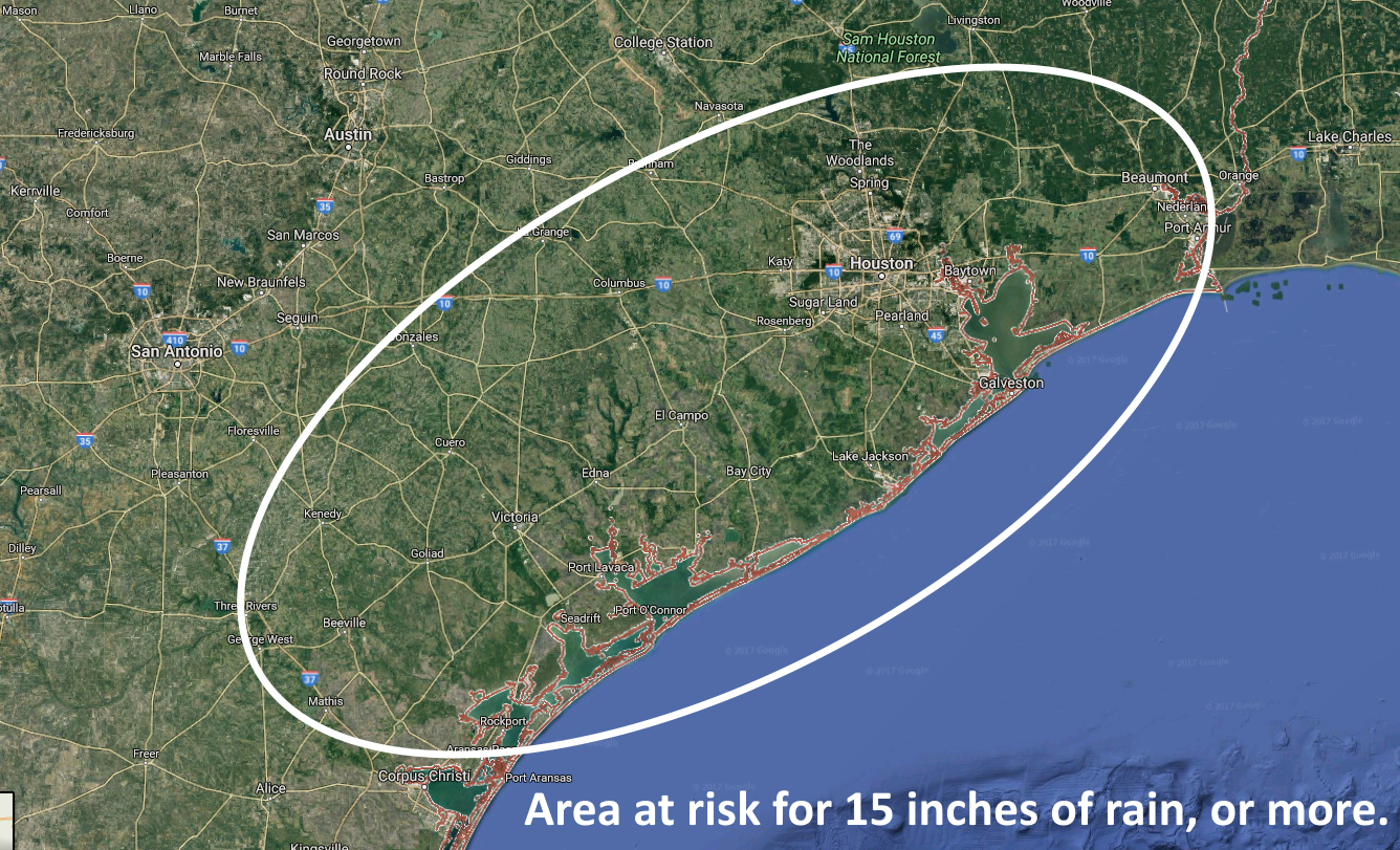
At that point we would have a situation where a low pressure system is just inland, and able to draw lots of moisture from the Gulf of Mexico into the upper Texas coastal area. Without sounding alarmist, we should say that this is a nearly perfect scenario for continuous heavy rainfall and flooding. That does not mean it will happen, but at this point it seems likely. Large areas will likely see 5 to 15 inches of rainfall, and smaller areas may see in excess of 20 inches.
LINK
This post was edited on 8/23/17 at 7:02 am
Posted on 8/23/17 at 7:05 am to Dire Wolf
The gfs rainfall forecast between now and September 1st is not catastrophic for anyone in LA. From this time yesterday morning, to this morning, totals have backed WAY off. Again, I'm no expert. And these models change every 6 hours.
This post was edited on 8/23/17 at 7:15 am
Posted on 8/23/17 at 7:13 am to rds dc
Recon is flying and has probably found enough to support an upgrade at 10:00 am but Harvey is still very disorganized.


Posted on 8/23/17 at 7:17 am to jorconalx
Posted on 8/23/17 at 7:19 am to rds dc
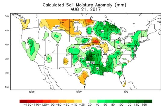
Soils are certainly saturated in many areas, not much ability to handle excessive rainfall.
Posted on 8/23/17 at 7:29 am to rds dc
That ULL sitting over the northern Gulf (Red) area is still one of the main drivers keeping Harvey in check. Shear and dry air associated with that will have to move out of the way before Harvey can get going.

At 12z, Harvey is still a strung out mess, so development should be slow:
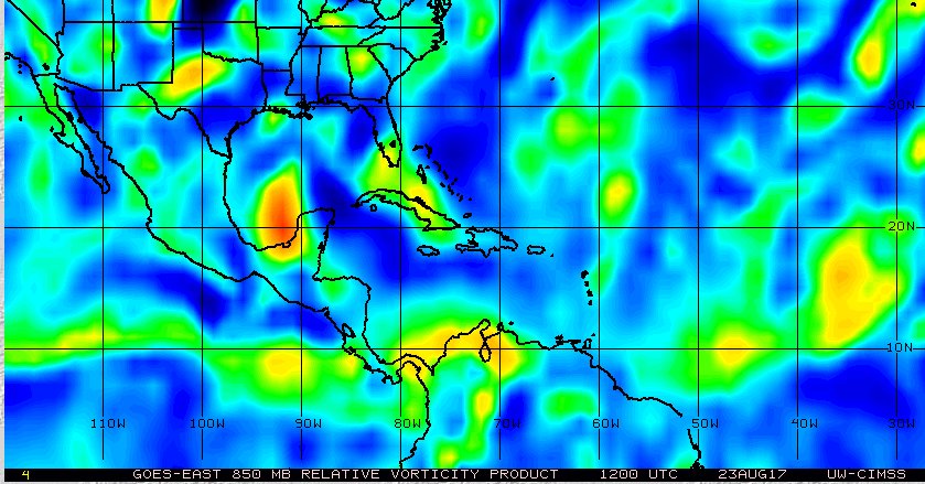

At 12z, Harvey is still a strung out mess, so development should be slow:
Posted on 8/23/17 at 7:30 am to rds dc
Advisories will start at 10am
quote:
Tropical Weather Outlook
NWS National Hurricane Center Miami FL
800 AM EDT Wed Aug 23 2017
For the North Atlantic...Caribbean Sea and the Gulf of Mexico:
1. Satellite images, reconnaissance data and surface observations
indicate that the remmants of Harvey are close to redeveloping into
a tropical depression over the southwestern Gulf of Mexico about 150
miles west of Merida, Mexico. Advisories will likely be re-initiated
at 10 am CDT on this system. The low is forecast to move to the
northwest at about 10 mph across the western Gulf of Mexico,
possibly reaching the northwestern Gulf coast late Friday. This
system is likely to slow down once it reaches the coast, increasing
the threat of a prolonged period of heavy rainfall and flooding
across portions of Texas and Louisiana into early next week. Harvey
could also produce storm surge and tropical storm or hurricane force
winds along portions of the Texas coast later this week, and
Tropical Storm or Hurricane Watches could be required later today
for portions of the coast of northeastern Mexico, Texas, and
southwestern Louisiana. Interests in these areas should monitor the
progress of this system and refer to products issued by your local
National Weather Service office for more information.
* Formation chance through 48 hours...high...near 100 percent.
* Formation chance through 5 days...high...near 100 percent.
This post was edited on 8/23/17 at 7:31 am
Posted on 8/23/17 at 7:35 am to GEAUXmedic
So if I'm in lake Charles Sunday It's a safe bet I should leave early?

 Page 30 of 618

Popular
Back to top