- My Forums
- Tiger Rant
- LSU Recruiting
- SEC Rant
- Saints Talk
- Pelicans Talk
- More Sports Board
- Fantasy Sports
- Golf Board
- Soccer Board
- O-T Lounge
- Tech Board
- Home/Garden Board
- Outdoor Board
- Health/Fitness Board
- Movie/TV Board
- Book Board
- Music Board
- Political Talk
- Money Talk
- Fark Board
- Gaming Board
- Travel Board
- Food/Drink Board
- Ticket Exchange
- TD Help Board
Customize My Forums- View All Forums
- Show Left Links
- Topic Sort Options
- Trending Topics
- Recent Topics
- Active Topics
Started By
Message
 0
0

Posted on 9/21/18 at 9:03 pm to rds dc
00z 3k NAM crushes the northern burbs overnight with a max of 14"

Posted on 9/21/18 at 9:08 pm to rds dc

Mesoscale Precipitation Discussion 0877
NWS Weather Prediction Center College Park MD
1005 PM EDT Fri Sep 21 2018
Areas affected...Dallas-Fort Worth Metro Area
Concerning...Heavy rainfall...Flash flooding likely
Valid 220204Z - 220630Z
Summary...Dangerous and life-threatening flash flooding is
developing in the immediate Dallas-Ft. Worth Metro Area this
evening. Persistent thunderstorms and heavy rain are likely to
lead to significant rainfall totals. Rain rates should reach (or
locally exceed) 3 in/hr in the strongest rain bands and
thunderstorms.
Discussion...Significant flash flooding is just beginning to
develop in North Texas, and specifically the immediate Dallas-Ft.
Worth metro area. An increasing concentration of thunderstorms and
heavy convective rain bands are expected during the evening very
near a developing surface low. Hi-res models had originally
projected this to be a little further west, but 01Z surface
observations showed the lowest pressures over Tarrant County, as
well as a coherent circulation to the surface winds. The hi-res
models were insistent that the heaviest rain would be concentrated
in the immediate vicinity of the surface low, and perhaps just to
the north-northeast, where low-level confluence will be maximized
(low -topped convection could thus be increasingly channeled into
this area). This would also be an area on the northern cusp of
broad southerly inflow and situated right in the middle of a
bubble of deep moisture. Therefore, the expectation is that the
hi-res models generally assessed the heavy rainfall potential with
this feature correctly, it will just end up being shifted further
east, and into the DFW metro area. GPS-PW observations in the
region were around 2.4 inches, significant values and above the
99th percentile in the regional climatology. The expectation of an
increasing concentration of convection in the immediate vicinity
of DFW metro is also implied by remote sensing data, with KFWS
radar and GOES-16 satellite showing these trends well.
Accounting for the low ZDR bias at KFWS still implies numerous
small droplets in the convective rain bands when examining the
dual pol datasets. The overall environment (very high PW and
MLCAPE over 500 j/kg) will support highly efficient rain
production, and this is confirmed by the dual pol data. This sort
of environment would make 3+ in/hr rain rates achievable in large,
relatively steady-state, and slow-moving convective bands. Several
mesonet sites in the vicinity of Plano have already reported rain
rates around 2 in/hr and some water rescues were reported in
Denton County. The expectation of significant rain rates
persisting for (at least) several hours over a large urban area
suggests that dangerous, life-threatening flash flooding will
continue to develop this evening. Radar trends also suggest this
flooding could affect a large portion of the DFW metro area and
surrounding counties, and thus travel could become increasingly
difficult with numerous flooded and impassible roads, particularly
dangerous at nighttime. Therefore, this focused mesoscale
precipitation discussion has been issued to highlight this
enhanced threat for dangerous flash flooding.
Lamers
ATTN...WFO...FWD...OUN...
Posted on 9/21/18 at 9:16 pm to rds dc
Nearly 2 million people currently under Flash Flood Warnings in the DFW area.

Posted on 9/21/18 at 9:18 pm to rds dc

We’re about to get slammed

Posted on 9/21/18 at 9:20 pm to rds dc
I was just on 75 last week North of SMU
Posted on 9/21/18 at 9:20 pm to 50_Tiger
quote:
Where you at McCaig?
Hopefully in between that crazy blondes big ole titties
Posted on 9/21/18 at 9:22 pm to LaBR4
quote:
I was just on 75 last week North of SMU
Could’ve been you.

Posted on 9/21/18 at 9:23 pm to shawnlsu
nah baw. she gone
Posted on 9/21/18 at 9:23 pm to LaBR4
quote:
I was just on 75 last week North of SMU
My Uber from Love Field was on 75 earlier today!
Posted on 9/21/18 at 9:25 pm to rds dc
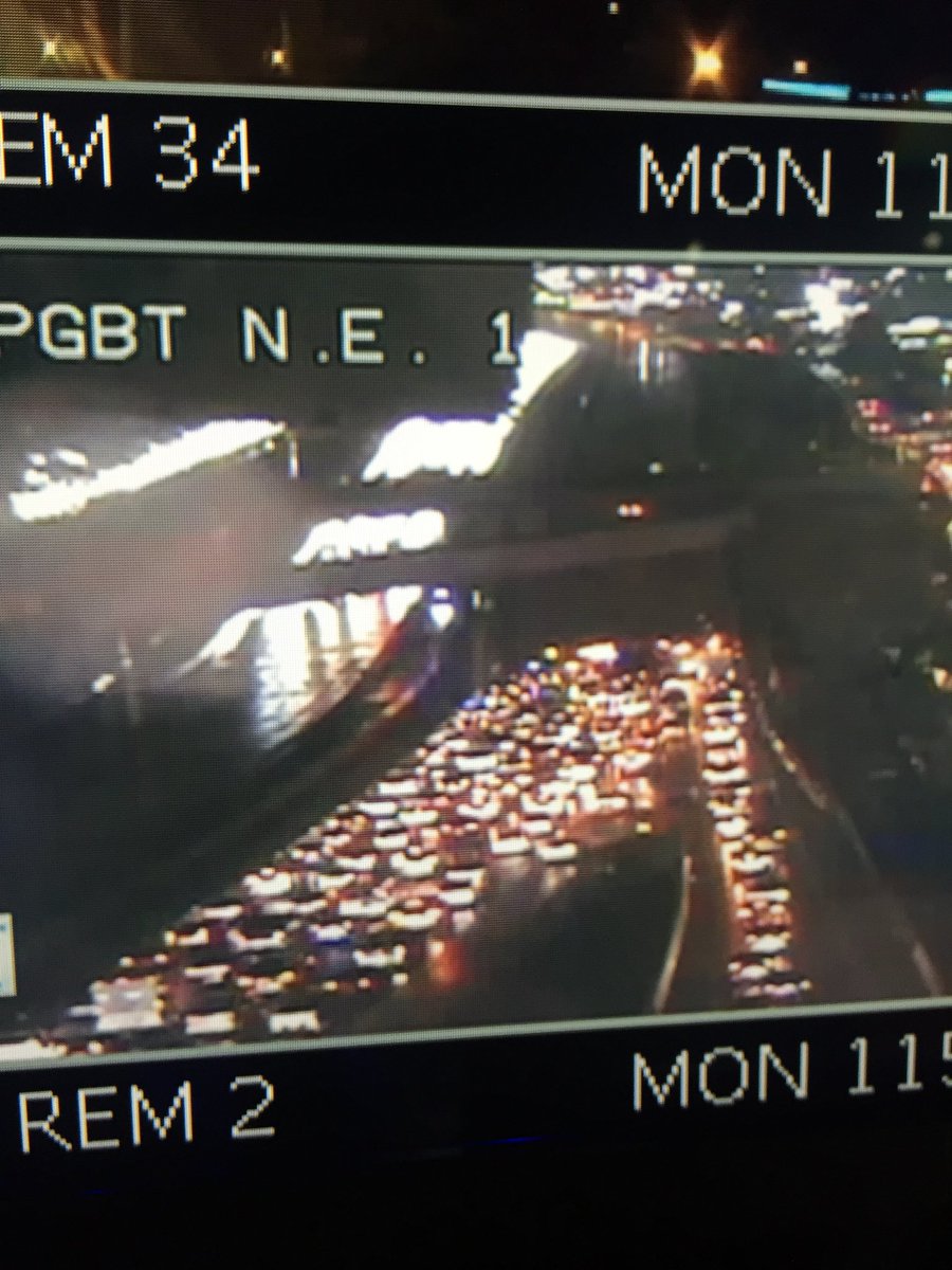
rds, might be able to see the water at the 75/Bush stack via NTTA.org.
It’s closed there.
It’s closed there.
Posted on 9/21/18 at 9:26 pm to rds dc
LOL YOU BEAT ME TO IT
Posted on 9/21/18 at 9:26 pm to rds dc
Traffic hell with water rising.
Not ideal.
Not ideal.
Posted on 9/21/18 at 9:28 pm to Duke
quote:
Traffic hell with water rising.
Not ideal.
Lots of reports coming in of people having to abandon cars on various roadways across DFW.
Posted on 9/21/18 at 9:29 pm to rds dc
Avoid the DNT near SRT. Bucue accidents
Posted on 9/21/18 at 9:30 pm to rds dc
Plano checking in. Water's just gushing down the block and down the alley.
Looks like we're gonna be in a weird lil valley of calm for a bit.
Looks like we're gonna be in a weird lil valley of calm for a bit.
Posted on 9/21/18 at 9:47 pm to messyjesse
My house backs up to Bear Creek. Should be an epic flow back there. Too dark to take pics right now. I'll get some in the morning.


Posted on 9/21/18 at 9:50 pm to rds dc
Reports of a road washing out in Keller and multiple water rescues are now under way.

 Page 2 of 3

Popular
Back to top