- My Forums
- Tiger Rant
- LSU Recruiting
- SEC Rant
- Saints Talk
- Pelicans Talk
- More Sports Board
- Fantasy Sports
- Golf Board
- Soccer Board
- O-T Lounge
- Tech Board
- Home/Garden Board
- Outdoor Board
- Health/Fitness Board
- Movie/TV Board
- Book Board
- Music Board
- Political Talk
- Money Talk
- Fark Board
- Gaming Board
- Travel Board
- Food/Drink Board
- Ticket Exchange
- TD Help Board
Customize My Forums- View All Forums
- Show Left Links
- Topic Sort Options
- Trending Topics
- Recent Topics
- Active Topics
Started By
Message
re: Big Cold Blast Coming - Increasing chances of ice/light snow flurries Tuesday afternoon
Posted on 1/12/18 at 3:44 pm to boxcarbarney

Posted on 1/12/18 at 3:44 pm to boxcarbarney
quote:
I wanted to set my own body on fire to keep warm.
You should've started with your pussy.
 2
2


Posted on 1/12/18 at 3:44 pm to TDsngumbo

Posted on 1/12/18 at 3:56 pm to TDsngumbo
NWS Houston discussion:
quote:
Models are in fairly good agreement bringing the frontal boundary, and associated precipitation ahead of and behind it, into southeast Texas late Monday night and Tuesday. It`s still too early to accurately predict the thermal profile at the surface and aloft that far out, but chances are that portions of the area may see precip transition from liquid to frozen at some point as temperatures fall through the day. Expect changes to the forecast as time gets closer, details become more clear (hopefully), and forecast confidence improves.
This post was edited on 1/12/18 at 3:58 pm
Posted on 1/12/18 at 4:04 pm to LSUJuice
I-40 between MM 120 and MM 119 outside Nashville

Posted on 1/12/18 at 4:04 pm to TDsngumbo
A few minutes after 2 we had about 5 minutes of light flurries in Franklinton.

Posted on 1/12/18 at 4:07 pm to 9Fiddy
quote:
Had to chip the car door open.
I had to heat up some water and pour it all over my door to get it open.
That’s some Yankee bullshite right there.
This post was edited on 1/12/18 at 4:15 pm
Posted on 1/12/18 at 4:15 pm to alajones
It definitely looks like our chances are great this time around. Probably won't be like December 8th but the chances of everyone seeing something look good.

Posted on 1/12/18 at 4:16 pm to TDsngumbo
Posted on 1/12/18 at 4:21 pm to LaBR4
Tuesday or Wednesday?

Posted on 1/12/18 at 4:25 pm to TDsngumbo
quote:
You should've started with your pussy
You should save some of that salt for the icy roads.
Posted on 1/12/18 at 4:25 pm to fishfighter
Tuesday evening, as it stands right now, looks to be the best time frame for the BR area.
Also, Tuesday's high is going to be early in the morning with the temperature falling fast throughout the day. It's quite possible we fall to and remain near freezing for most of the day with off and on showers. The official forecast is for Tuesday evening to be dicey but the afternoon could get interesting as well. It would catch a lot of people off guard if it does.
Also, Tuesday's high is going to be early in the morning with the temperature falling fast throughout the day. It's quite possible we fall to and remain near freezing for most of the day with off and on showers. The official forecast is for Tuesday evening to be dicey but the afternoon could get interesting as well. It would catch a lot of people off guard if it does.
Posted on 1/12/18 at 4:28 pm to TDsngumbo
Latest GFS came in just a bit warmer for the Houston area.
Posted on 1/12/18 at 4:31 pm to TDsngumbo
Thanks. 
Posted on 1/12/18 at 4:33 pm to biggsc
quote:
I-40 between MM 120 and MM 119 outside Nashville
Somehow, it is the driver of the Wiley Sanders truck at fault.
Posted on 1/12/18 at 4:37 pm to TU Rob
quote:
Somehow, it is the driver of the Wiley Sanders truck at fault.
Looks like it.
Posted on 1/12/18 at 4:54 pm to TDsngumbo
18z GFS sounding for BR on Tuesday during the day look promising. A bit of a warm nose present just above the ground but it's subtle and a good moist column to work with. Would actually like a little bit drier just above the surface to get some wet bulb action.
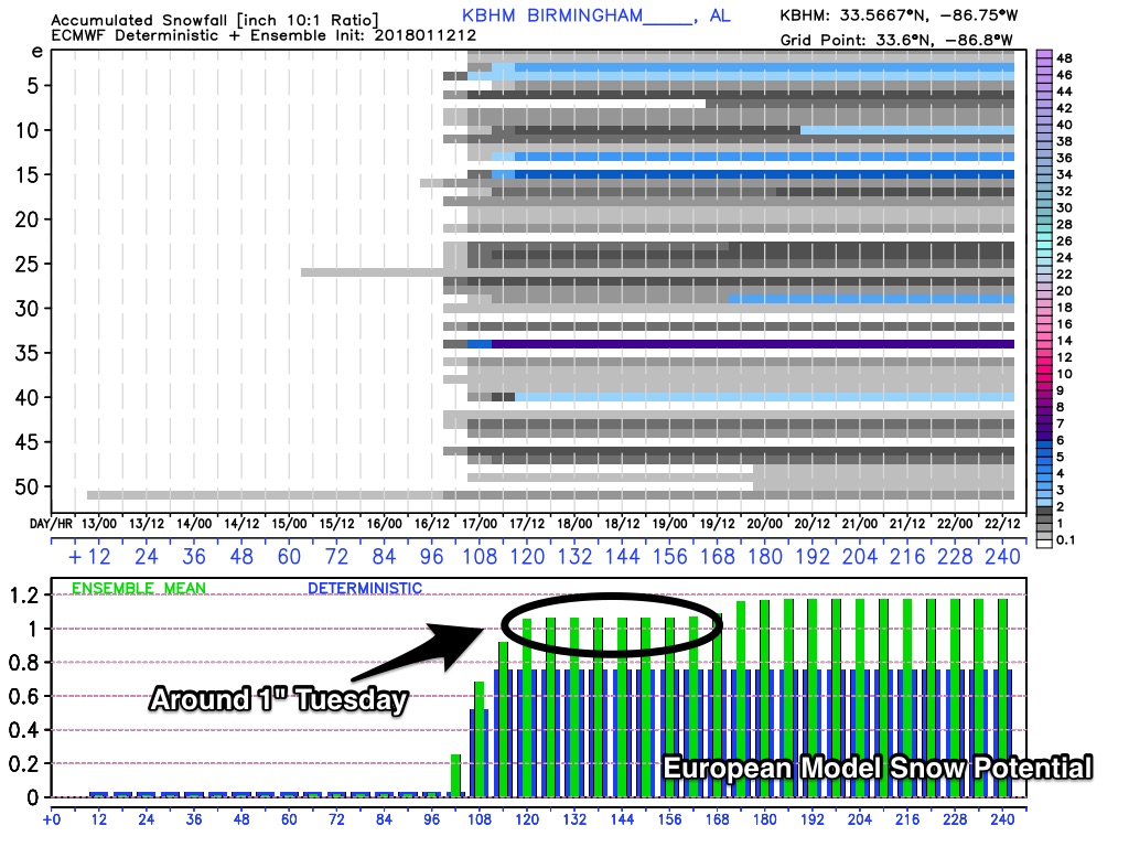
Up into Alabama, the GFS seemed to let Birmingham miss out on the action but their sounding looked great for snow. Sets up that everyone in the SE needs to keep an eye on things.
Up into Alabama, the GFS seemed to let Birmingham miss out on the action but their sounding looked great for snow. Sets up that everyone in the SE needs to keep an eye on things.

Posted on 1/12/18 at 4:57 pm to gizmothepug
quote:
A few minutes after 2 we had about 5 minutes of light flurries in Franklinton.
Was that on the Hill or on the southside of town
Posted on 1/12/18 at 5:30 pm to LSU316
my Weatherbug app says 50% chance of frozen mix on Monday night and a 70% chance of frozen mix on Tuesday for Pineville, La.
Posted on 1/12/18 at 5:39 pm to LSU316
The hill, I was in the pickup line at the primary school. Lol.
Posted on 1/12/18 at 5:51 pm to Duke
quote:Wut? Translation for the dummies like me, please.
18z GFS sounding for BR on Tuesday during the day look promising. A bit of a warm nose present just above the ground but it's subtle and a good moist column to work with. Would actually like a little bit drier just above the surface to get some wet bulb action.

 Page 4 of 82

Popular
Back to top