- My Forums
- Tiger Rant
- LSU Recruiting
- SEC Rant
- Saints Talk
- Pelicans Talk
- More Sports Board
- Fantasy Sports
- Golf Board
- Soccer Board
- O-T Lounge
- Tech Board
- Home/Garden Board
- Outdoor Board
- Health/Fitness Board
- Movie/TV Board
- Book Board
- Music Board
- Political Talk
- Money Talk
- Fark Board
- Gaming Board
- Travel Board
- Food/Drink Board
- Ticket Exchange
- TD Help Board
Customize My Forums- View All Forums
- Show Left Links
- Topic Sort Options
- Trending Topics
- Recent Topics
- Active Topics
Started By
Message
re: A map of every tornado emergency ever issued
Posted on 4/19/21 at 12:00 pm to Hawgeye

Posted on 4/19/21 at 12:00 pm to Hawgeye
quote:
I’m not sure about that. The Tulsa Metro is in a hot alley for tornado activity as is the OKC Metro area.
I'm not necessarily talking about metro areas. Just overall population density. Rural northern Alabama population is higher density than rural Kansas/Oklahoma.
 0
0

Posted on 4/19/21 at 12:00 pm to When in Rome
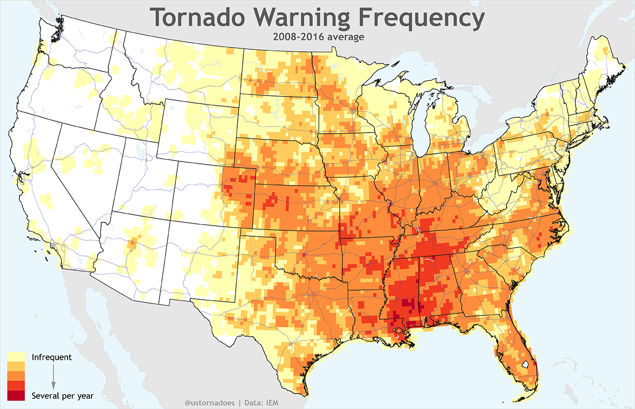
The average Warning Map not emergency
This post was edited on 4/19/21 at 12:01 pm
Posted on 4/19/21 at 12:03 pm to LegendInMyMind
Also, terrain and the ability to get eyes on a tornado makes a huge difference. Out west they have low-precip supercells that put down easy to spot and track tornadoes. Hell, they regularly use helicopters to track tornadoes. With the high-precip storms we have, and the trees, and the hills and hollers, and the creeks and rivers, it is infinitely harder to confirm a tornado on the ground. So if there was a confirmed tornado doing damage in a rural area, and it is headed towards a populated area but they've lost visual they will, out of an abundance of caution, issue the warning with a Tornado Emergency tag. It is the best approach.
Posted on 4/19/21 at 12:03 pm to dawgfan24348
quote:
The difference in Georgia and Alabama is insane
Who issues tornado emergencies? Is it tbe local NWS office or some national center, like the SPC?
If the former, it better explains the abrupt ending of the tornado emergencies at the Alabama - Georgia state line
Posted on 4/19/21 at 12:05 pm to Itismemc
So don’t live in New Orleans, Jackson, or Birmingham.
Edit: or Nashville
Edit: or Nashville
This post was edited on 4/19/21 at 12:08 pm
Posted on 4/19/21 at 12:06 pm to When in Rome
Fact check - Not a legit map. I don't see any "TORNADOS SPOTTED IN LIVINGSTON!!!" on that map.
Posted on 4/19/21 at 12:08 pm to East Coast Band
quote:
Who issues tornado emergencies? Is it tbe local NWS office or some national center, like the SPC?
The NWS local office will issue the Tornado Emergency.
There's a ton of research going on now into what protects GA from seeing tornadoes, particularly violent tornadoes, compared to Alabama. Geography is likely the biggest factor. Also, the nature of the storms and the time of day they most often develop over MS and AL has a whole lot to do with it.

Posted on 4/19/21 at 12:10 pm to When in Rome
Even nature hates Tuscaloosa.
Posted on 4/19/21 at 12:26 pm to When in Rome
Another thing to think about:
Imagine a day like April 27, 2011, or any day where there is a threat for long-track violent tornadoes. Take one of the EF5 tornadoes in Alabama that day. It was on the ground for 132 miles, from near Hamilton, AL to near Huntland, TN.
Now, look at a map of Alabama and the cities/towns potentially in or near the path of that thing, and what vital infrastructure was in those towns (Nuclear plants, chemical plants, major rail hub on the river, multiple industrial parks along the river, etc). 132 miles of Alabama/Tennessee ground was covered. Overlay that 132 mile path onto the Plains states. Go to West Texas or Western Oklahoma. You can have a violent tornado on the ground for 100+ miles out there and it may never get near an area with any significant population.

 Page 2 of 2


Popular
Back to top