- My Forums
- Tiger Rant
- LSU Recruiting
- SEC Rant
- Saints Talk
- Pelicans Talk
- More Sports Board
- Fantasy Sports
- Golf Board
- Soccer Board
- O-T Lounge
- Tech Board
- Home/Garden Board
- Outdoor Board
- Health/Fitness Board
- Movie/TV Board
- Book Board
- Music Board
- Political Talk
- Money Talk
- Fark Board
- Gaming Board
- Travel Board
- Food/Drink Board
- Ticket Exchange
- TD Help Board
Customize My Forums- View All Forums
- Show Left Links
- Topic Sort Options
- Trending Topics
- Recent Topics
- Active Topics
Started By
Message

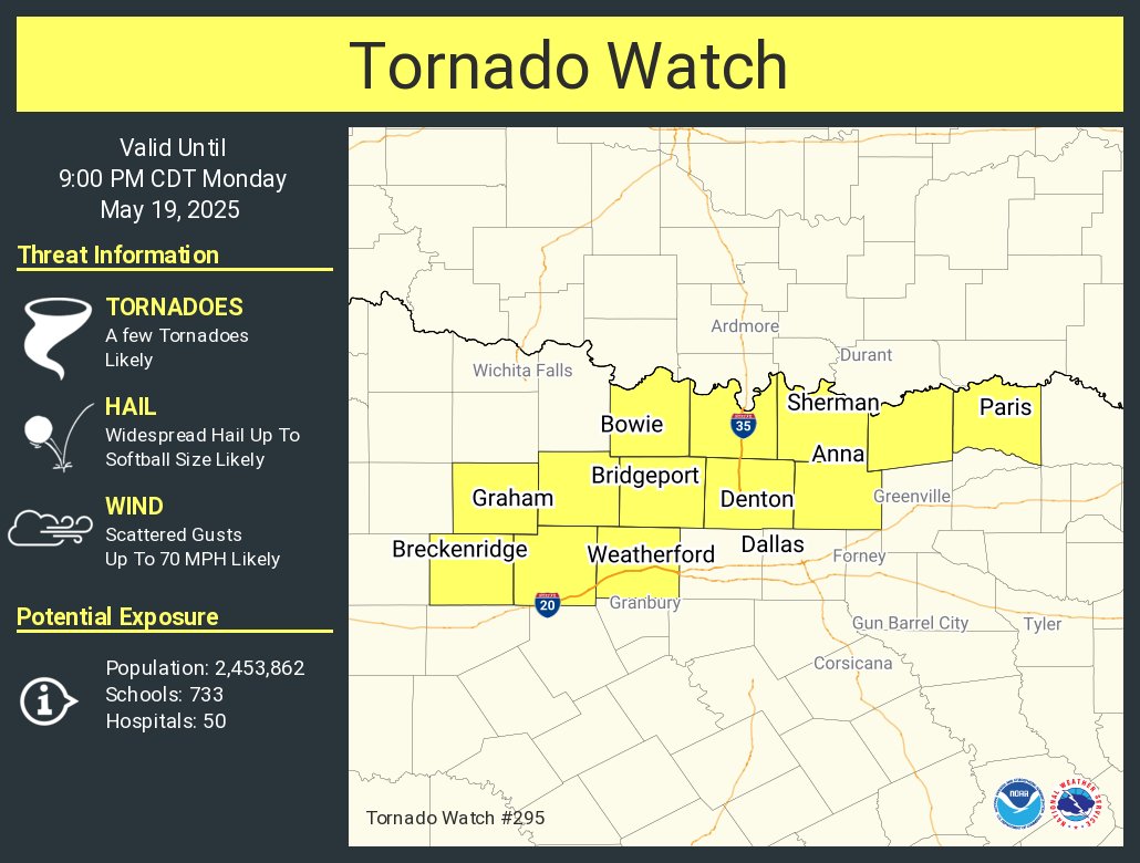
Severe Weather: May 19-20, 2025
Posted on 5/19/25 at 9:57 am

Posted on 5/19/25 at 9:57 am
(no message)
This post was edited on 5/21/25 at 5:29 am
 20
20

Posted on 5/19/25 at 10:03 am to Roll Tide Ravens
Posted on 5/19/25 at 10:08 am to Roll Tide Ravens

Posted on 5/19/25 at 10:28 am to TT9
No offer what happened yesterday am, but we lost power in bessemer from 6am until 1am this morning. Im in CO due to my FIL passing, but could see on my security app
Posted on 5/19/25 at 10:48 am to Thracken13
quote:
No offer what happened yesterday am, but we lost power in bessemer from 6am until 1am this morning. Im in CO due to my FIL passing, but could see on my security app
Yeah, there was a rough cluster of severe storms that came through Tuscaloosa County, southern Jefferson County and Shelby County between 6-7am yesterday. At one point NWS Birmingham put a “Destructive” tag on the severe thunderstorm warning because the storms had been producing winds up to 80 mph in Tuscaloosa County.
This post was edited on 5/19/25 at 10:49 am
Posted on 5/19/25 at 10:54 am to Roll Tide Ravens
How many straight days have we had of moderate risk for severe weather?
Will this be a tornado outbreak that's studied by meteorologists for years just for its longevity if not also ferocity?
Will this be a tornado outbreak that's studied by meteorologists for years just for its longevity if not also ferocity?
Posted on 5/19/25 at 10:57 am to Roll Tide Ravens
RTR, keep me safe in Northwest Arkansas today!
Posted on 5/19/25 at 11:12 am to BallHawg10
All depends on storm mode.
Mass convection and it becomes a more wind,hail, qlcs event.
Less convection and we got big nader problems.
Plenty of instability and wind shear will increase as the day rolls on.
Mass convection and it becomes a more wind,hail, qlcs event.
Less convection and we got big nader problems.
Plenty of instability and wind shear will increase as the day rolls on.
Posted on 5/19/25 at 11:15 am to Roll Tide Ravens
Heads up to the central Alabama folks for tomorrow. You all won't have weather radio coverage for tomorrow. Transmitters will be down for a scheduled upgrade.
Loading Twitter/X Embed...
If tweet fails to load, click here.
Posted on 5/19/25 at 11:19 am to Roll Tide Ravens
Those poor people in London and Somerset, Kentucky don't need this that's for sure.
Kentucky as a whole has taken a beating with severe weather this spring. We're pretty over it.
Kentucky as a whole has taken a beating with severe weather this spring. We're pretty over it.
Posted on 5/19/25 at 11:19 am to Roll Tide Ravens
Oh heck yeah. Im in that red circle there for today. Good day to sit on my porch with a pipe and sativa and watch a downpour.

Posted on 5/19/25 at 11:20 am to Roll Tide Ravens
TSTM FTW
Posted on 5/19/25 at 11:30 am to Cosmo
I think our local power company got everybody back on line last night. Now to see if the bulge to the east gets stronger this afternoon.
Posted on 5/19/25 at 11:33 am to Roll Tide Ravens
We may never fully understand tornadoes and the storms that produce them.
This was probably a mile and half wide tornado that was bearing down on the small town of Plevna, Kansas (84 people) last night. A perfectly-timed start to the occlusion process appears to have shifted this tornado's path slightly and weakening it somewhat, making it just barely miss the main part of that tiny town. Unreal.
This was probably a mile and half wide tornado that was bearing down on the small town of Plevna, Kansas (84 people) last night. A perfectly-timed start to the occlusion process appears to have shifted this tornado's path slightly and weakening it somewhat, making it just barely miss the main part of that tiny town. Unreal.
Loading Twitter/X Embed...
If tweet fails to load, click here.Posted on 5/19/25 at 12:06 pm to LegendInMyMind

Posted on 5/19/25 at 12:08 pm to LegendInMyMind
quote:
Heads up to the central Alabama folks for tomorrow. You all won't have weather radio coverage for tomorrow. Transmitters will be down for a scheduled upgrade.
I’m on record for my deep admiration for NWS Birmingham. However, with the severe weather threat tomorrow, that’s really bad timing for a transmitter upgrade. I guess there was no way to put it off, because I’m sure they would have if they could have.

Posted on 5/19/25 at 12:15 pm to Roll Tide Ravens
quote:
I guess there was no way to put it off, because I’m sure they would have if they could have.
It is probably similar to the radar upgrades from a year or two back. I guess if they look for the absolute perfect time to do all the work, assuming this is being done to many transmitters around the country, they could probably never develop a schedule to get it all done. I guess it just is what it is.
Posted on 5/19/25 at 12:16 pm to LegendInMyMind
quote:
is probably similar to the radar upgrades from a year or two back. I guess if they look for the absolute perfect time to do all the work, assuming this is being done to many transmitters around the country, they could probably never develop a schedule to get it all done. I guess it just is what it is.
Yeah, I imagine that they have to get the techs who do this stuff in when they can, so there probably isn’t much room to change the schedule. There’s probably not much the local NWS office can do.
Posted on 5/19/25 at 12:24 pm to Roll Tide Ravens
Forget Texas/Oklahoma... the Mid-South and north-central AL are the new Tornado Alley
Posted on 5/19/25 at 2:11 pm to razorbackfan4life


 Page 1 of 16

Popular
Back to top