- My Forums
- Tiger Rant
- LSU Recruiting
- SEC Rant
- Saints Talk
- Pelicans Talk
- More Sports Board
- Fantasy Sports
- Golf Board
- Soccer Board
- O-T Lounge
- Tech Board
- Home/Garden Board
- Outdoor Board
- Health/Fitness Board
- Movie/TV Board
- Book Board
- Music Board
- Political Talk
- Money Talk
- Fark Board
- Gaming Board
- Travel Board
- Food/Drink Board
- Ticket Exchange
- TD Help Board
Customize My Forums- View All Forums
- Show Left Links
- Topic Sort Options
- Trending Topics
- Recent Topics
- Active Topics
Started By
Message
re: Severe Weather Rolls On: May 7-10, 2024
Posted on 5/7/24 at 5:02 pm to Bobby OG Johnson

Posted on 5/7/24 at 5:02 pm to Bobby OG Johnson
 3
3

Posted on 5/7/24 at 5:03 pm to IAmNERD
66.5 Vrot on the southern tornado.
Posted on 5/7/24 at 5:06 pm to Bobby OG Johnson
Lots of little beans on radar now. Everything is trying to rotate.
Posted on 5/7/24 at 5:08 pm to LegendInMyMind
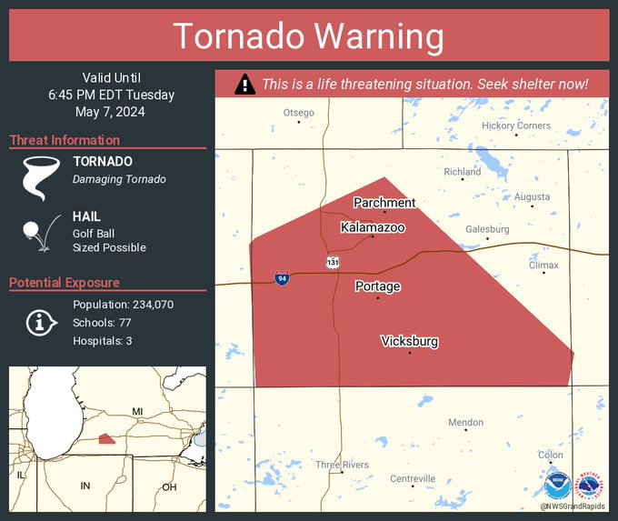
PDS warning for Kalamazoo.
Posted on 5/7/24 at 5:09 pm to Bobby OG Johnson
Posted on 5/7/24 at 5:13 pm to Bobby OG Johnson
The one south of Kalamazoo and I-94 has a noticeable debris signature.

Posted on 5/7/24 at 5:16 pm to Ghost of Colby
Tornado Emergency for Union City, MI. Large tornado near Kalamazoo
Posted on 5/7/24 at 5:19 pm to Ghost of Colby
Even the storms down into IN are rotating.
Posted on 5/7/24 at 5:25 pm to Pisco
three tornado warnings in five minutes
Posted on 5/7/24 at 5:26 pm to LegendInMyMind
The density of towns and cities is much higher in MI and IN than in OK and KS. Most of these tornados will likely hit populated areas.
This post was edited on 5/7/24 at 5:27 pm
Posted on 5/7/24 at 5:27 pm to Bobby OG Johnson

Posted on 5/7/24 at 5:34 pm to Bobby OG Johnson
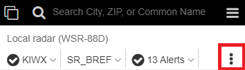
I don't like when the NWS puts yellow or red boxes over the radar - you can't tell what is going on because the radar colors are obscured.
As in this link:
NWS radar
As in this link:
NWS radar
Posted on 5/7/24 at 5:44 pm to NorthEndZone
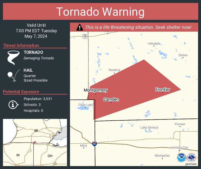
PDS for Reading, MI.
Posted on 5/7/24 at 5:44 pm to chinhoyang
You change change the opacity of a layer (radar, warnings, etc) by clicking on the 3 vertical black dots and using the slider bars...
This post was edited on 5/7/24 at 5:49 pm
Posted on 5/7/24 at 5:46 pm to Bobby OG Johnson
Posted on 5/7/24 at 5:48 pm to Zapps4Life
Thanks.

Posted on 5/7/24 at 6:15 pm to Roll Tide Ravens
Nasty storm south of Ft. Wayne, IN.

Posted on 5/7/24 at 6:22 pm to Roll Tide Ravens
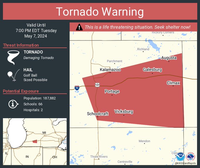
Another confirmed large and extremely dangerous tornado near Kalamazoo.
Tornado Warning
National Weather Service Grand Rapids MI
720 PM EDT Tue May 7 2024
The National Weather Service in Grand Rapids has issued a
* Tornado Warning for... East central Kalamazoo County in southwestern Michigan...
* Until 815 PM EDT.
* At 720 PM EDT, a confirmed large and extremely dangerous tornado was located near Portage, moving east at 30 mph.
This is a PARTICULARLY DANGEROUS SITUATION. TAKE COVER NOW!
HAZARD...Damaging tornado.
SOURCE...Weather spotters confirmed tornado.
Posted on 5/7/24 at 6:25 pm to Roll Tide Ravens
This was the earlier tornado near Kalamazoo (near Portage, MI).
Now there is another confirmed tornado in that area.
Loading Twitter/X Embed...
If tweet fails to load, click here. Now there is another confirmed tornado in that area.
Posted on 5/7/24 at 6:29 pm to Roll Tide Ravens


 Page 2 of 36

Popular
Back to top