- My Forums
- Tiger Rant
- LSU Recruiting
- SEC Rant
- Saints Talk
- Pelicans Talk
- More Sports Board
- Fantasy Sports
- Golf Board
- Soccer Board
- O-T Lounge
- Tech Board
- Home/Garden Board
- Outdoor Board
- Health/Fitness Board
- Movie/TV Board
- Book Board
- Music Board
- Political Talk
- Money Talk
- Fark Board
- Gaming Board
- Travel Board
- Food/Drink Board
- Ticket Exchange
- TD Help Board
Customize My Forums- View All Forums
- Show Left Links
- Topic Sort Options
- Trending Topics
- Recent Topics
- Active Topics
Started By
Message
re: UPDATE: Another Potential Severe Weather Event for the South (insert dates)
Posted on 3/27/21 at 4:37 pm to Bobby OG Johnson
Posted on 3/27/21 at 4:37 pm to Bobby OG Johnson
Yep. Figured that was coming.
 2
2

Posted on 3/27/21 at 4:38 pm to LegendInMyMind
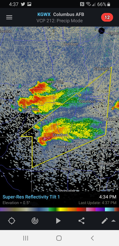
Crawford, MS may be soon.

Posted on 3/27/21 at 4:39 pm to LegendInMyMind
Posted on 3/27/21 at 4:40 pm to Bobby OG Johnson
Which storm is he on? Can't look at the moment.

Posted on 3/27/21 at 4:41 pm to LegendInMyMind
quote:
Which storm is he on? Can't look at the moment.
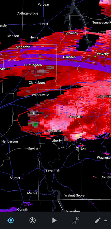
Tornado warned storm near Henderson, TN.
Posted on 3/27/21 at 4:42 pm to Roll Tide Ravens
I need that storm in Lawrence County, AL to behave.
Posted on 3/27/21 at 4:44 pm to LegendInMyMind
quote:
need that storm in Lawrence County, AL to behave.
I’ve got a severe warned thunderstorm approaching me north of Birmingham. Broad rotation in it.
Posted on 3/27/21 at 4:45 pm to LegendInMyMind

Posted on 3/27/21 at 4:48 pm to Bobby OG Johnson
Lot of nasty single cells popping up across ark-miss-ala
This could be worse than expected if they mature
This could be worse than expected if they mature
Posted on 3/27/21 at 4:49 pm to Bobby OG Johnson
PDS tornado warning on the storm east of Henderson, TN. Confirmed large and extremely dangerous tornado.
Posted on 3/27/21 at 4:50 pm to deltaland
From SHV forecast discussion
Sun just popped out for the first time all day here in Shreveport
quote:
With all of the Ark-La-Tex in the warm sector for multiple hours today, the atmosphere is primed for severe weather as convection begins. Diverse cloud cover hints at a tinderbox-like situation aloft, with deepening cumulus, and more insolation reaching the I-20 corridor. This afternoon`s special sounding confirms the continued presence of multiple ingredients for severe weather including: CAPE values near 3000 J/kg, bulk shear at or above 50 knots areawide, and mid-level lapse rates at around 7.0 C/km. The lack of synoptic-scale forcing is what is primarily working against an even stronger severe weather situation. Regardless, the severe weather risks for today will be maximized in a window from now until 11PM, with very large hail and even the outside possibility of a strong tornado in this time frame.
Sun just popped out for the first time all day here in Shreveport
Posted on 3/27/21 at 4:51 pm to Roll Tide Ravens
quote:
PDS tornado warning on the storm east of Henderson, TN. Confirmed large and extremely dangerous tornado.
It is in the best atmosphere currently. Terrible position for radar, though.
Everything has some spin to it. Most of it is broad.
This post was edited on 3/27/21 at 4:52 pm
Posted on 3/27/21 at 4:53 pm to LegendInMyMind
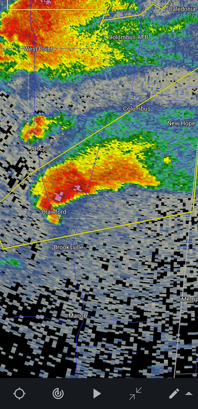
Reflectivity alone on the Crawford storm is there. Not much rotation yet.
Posted on 3/27/21 at 4:57 pm to LegendInMyMind
Two parallel storms tornado warned now. The one that was producing the big tornado and now the one south of it.
Posted on 3/27/21 at 4:59 pm to Bobby OG Johnson
I bet cell north of Birmingham gets warned
Posted on 3/27/21 at 4:59 pm to Roll Tide Ravens

Posted on 3/27/21 at 5:01 pm to deltaland
quote:
bet cell north of Birmingham gets warned
Everything is borderline right now with very broad rotation.
Posted on 3/27/21 at 5:01 pm to LegendInMyMind

Posted on 3/27/21 at 5:03 pm to LegendInMyMind
Looking at velocity with KOHX sucks right now. Almost useless.

 Page 71 of 86

Popular
Back to top