- My Forums
- Tiger Rant
- LSU Recruiting
- SEC Rant
- Saints Talk
- Pelicans Talk
- More Sports Board
- Fantasy Sports
- Golf Board
- Soccer Board
- O-T Lounge
- Tech Board
- Home/Garden Board
- Outdoor Board
- Health/Fitness Board
- Movie/TV Board
- Book Board
- Music Board
- Political Talk
- Money Talk
- Fark Board
- Gaming Board
- Travel Board
- Food/Drink Board
- Ticket Exchange
- TD Help Board
Customize My Forums- View All Forums
- Show Left Links
- Topic Sort Options
- Trending Topics
- Recent Topics
- Active Topics
Started By
Message
re: UPDATE: Another Potential Severe Weather Event for the South (insert dates)
Posted on 3/25/21 at 11:41 am to Govt Tide
Posted on 3/25/21 at 11:41 am to Govt Tide
Bruv, there's nearly no reason to chase in the SE. Too many trees, too many hills, stupid low LCLs, potential flooding, ect.
And that's if you know what you're doing.
And that's if you know what you're doing.
 1
1

Posted on 3/25/21 at 11:42 am to deltaland
quote:
Called that one. Eutaw cell now tornado warned
Good looking out there. Luckily don't see any debris on CC but it does have a nice little hailcore with it.
Posted on 3/25/21 at 11:42 am to Thracken13
I see 3 classic cells just NE of Jackson that will be trouble within an hour
This post was edited on 3/25/21 at 11:45 am
Posted on 3/25/21 at 11:43 am to Duke
I agree - as much as I love Severe weather and would love to chase tornados - no frickign way in AL
Posted on 3/25/21 at 11:49 am to Thracken13
quote:
I agree - as much as I love Severe weather and would love to chase tornados - no frickign way in AL
FTR, I'm not a chaser and wouldn't dare chase in Alabama or most of the Deep South for a typical run of the mill setup much less one with this type of volatile setup. Just want to make that clear.
I'm following it from the relative safety of my home down in Fairhope, AL...lol
Posted on 3/25/21 at 11:58 am to Govt Tide
I'm from Mobile myself - lived in Silverhill for a while - spent many weekends at the Fairhope Pier crabbing :)
FYI - the 5/5 risk area just got extended east beyond Birmingham - shot is about to break the fan.

FYI - the 5/5 risk area just got extended east beyond Birmingham - shot is about to break the fan.
This post was edited on 3/25/21 at 11:58 am
Posted on 3/25/21 at 12:02 pm to Thracken13
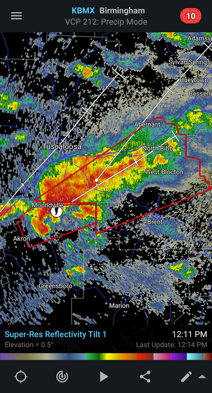
ABC3340 has a cam pointed at the storm approaching Moundville - if it is there they should get a good look at it.

Posted on 3/25/21 at 12:04 pm to Thracken13
Sigh. Moundville really doesn’t need this right now. My sister dodged a bullet last week. Her neighbors got hit pretty good. I hope it isn’t bad
Posted on 3/25/21 at 12:05 pm to Thracken13
TVS right at Pinson. Not much rotation there, though. Severe warned storm.
This post was edited on 3/25/21 at 12:07 pm
Posted on 3/25/21 at 12:06 pm to Pisco
quote:
Sigh. Moundville really doesn’t need this right now. My sister dodged a bullet last week. Her neighbors got hit pretty good. I hope it isn’t bad
Fortunately, right now it doesn't have the debris signature that last week's storm had.
Posted on 3/25/21 at 12:06 pm to Pisco
the one approaching Moundville could end up my neck of the woods in Birmingham - will see how far it gets.
really hope it isn't on the ground
really hope it isn't on the ground
Posted on 3/25/21 at 12:06 pm to Thracken13
That cell has a bit of a BWER looking at a few levels of radar tilt. That is a sign of a powerful tilted updraft.
Posted on 3/25/21 at 12:11 pm to Thracken13
I bet Carthage and Walnut Grove, ms cells get warned soon
Posted on 3/25/21 at 12:11 pm to Duke
quote:
That cell has a bit of a BWER looking at a few levels of radar tilt. That is a sign of a powerful tilted updraft.
You can see it just going through tilts on velocity. Offset pretty significantly.
Posted on 3/25/21 at 12:12 pm to LegendInMyMind
Warning for Moundville storm just got extended.
This post was edited on 3/25/21 at 12:16 pm
Posted on 3/25/21 at 12:14 pm to LegendInMyMind
yep that Cell is gonna track really damn close to me here south of Bham
Posted on 3/25/21 at 12:16 pm to Thracken13
That hook echo keeps getting nastier.
This post was edited on 3/25/21 at 12:17 pm
Posted on 3/25/21 at 12:18 pm to Thracken13
quote:
yep that Cell is gonna track really damn close to me here south of Bham
Watching closely from Pelham.
Pucker factor 1/10 and increasing.
Posted on 3/25/21 at 12:18 pm to SouthernHog
the new sweep it got damned tight
Posted on 3/25/21 at 12:19 pm to Thracken13
We will also have a chance for significant hail out of these storms. Large hail that we aren't used to in this part of the country.

 Page 22 of 86

Popular
Back to top