- My Forums
- Tiger Rant
- LSU Score Board
- LSU Recruiting
- SEC Rant
- SEC Score Board
- Saints Talk
- Pelicans Talk
- More Sports Board
- Coaching Changes
- Fantasy Sports
- Golf Board
- Soccer Board
- O-T Lounge
- Tech Board
- Home/Garden Board
- Outdoor Board
- Health/Fitness Board
- Movie/TV Board
- Book Board
- Music Board
- Political Talk
- Money Talk
- Fark Board
- Gaming Board
- Travel Board
- Food/Drink Board
- Ticket Exchange
- TD Help Board
Customize My Forums- View All Forums
- Show Left Links
- Topic Sort Options
- Trending Topics
- Recent Topics
- Active Topics
Started By
Message
re: Tornado outbreak, 94 dead, Upwards of 100 unaccounted for search/rescue & cleanup ongoing
Posted on 12/15/21 at 9:47 am to Duke
Posted on 12/15/21 at 9:47 am to Duke
quote:
Minnesota catching a moderate risk in December, thats new.
400mph storm motion. Shouldn't last but for around 10 minutes.
That is wild, though.
 1
1

Posted on 12/15/21 at 9:50 am to LegendInMyMind
quote:
400mph storm motion. Shouldn't last but for around 10 minutes.
That is wild, though.
watched a Ryan Hall Y'All video last night... he said if today's setup came during spring where the pre-frontal dew points were about 10 points higher... we'd be talking about a high level threat day from the SPC
Posted on 12/15/21 at 9:53 am to okietiger
quote:
Is the TorCon deal bullshite?
Back when Forbes first started doing it I remember having that conversation with my Pops. I basically said then that it was bullshite, but he didn't agree and his response made sense. He said that anything that can make more people weather aware was okay with him. I've come to take a "What's the harm?" view of it. The average person will never talk specifically about the SPC's tornado probability map, they probably don't even know about it, but I bet most recognize the "Torcon".

Posted on 12/15/21 at 9:54 am to okietiger
quote:
Gonna be a Minnesota thread today?
Edit: Iowa main “target”
Well, here in WI it's in the upper 50's which is WAY above normal for mid December.
Posted on 12/15/21 at 9:55 am to rt3
quote:
watched a Ryan Hall Y'All video last night... he said if today's setup came during spring where the pre-frontal dew points were about 10 points higher... we'd be talking about a high level threat day from the SPC
If they just had the temps and dews we had on Friday it may get it there.
Posted on 12/15/21 at 9:59 am to BuckyCheese
Uh oh:
quote:
...THERE IS A MODERATE RISK OF SEVERE THUNDERSTORMS WESTERN/CENTRAL/NORTHERN IOWA...SOUTHEAST MINNESOTA...AND FAR WEST-CENTRAL WISCONSIN...
...SUMMARY... Widespread severe wind gusts of 60-75 mph along with at least a few tornadoes are likely from late afternoon through this evening across the Mid-Missouri Valley to the Upper Mississippi Valley. Embedded gusts of 80-100 mph and a nocturnal strong tornado or two are also possible, particularly across western to northern Iowa and southeast Minnesota.
...Mid-MO to Upper MS Valley...
Primary changes with this outlook cycle are to expand severe probabilities westward in the central Great Plains, as well as add a significant tornado hatched area. Have maintained a Moderate Risk for the corridor of greatest derecho potential centered on this evening.

Posted on 12/15/21 at 10:12 am to rt3
quote:
it's my uneducated opinion that Tor:Con is TWC's bastardized version of the NWS's severe weather scale (low, moderate, high, etc.)
Ok, that's what I figured it was.
So dumb.
Posted on 12/15/21 at 10:27 am to LegendInMyMind
The high today is supposed to be 64.
Tomorrow is 34.
No idea how that plays into this.
Tomorrow is 34.
No idea how that plays into this.
Posted on 12/15/21 at 10:31 am to BuckyCheese
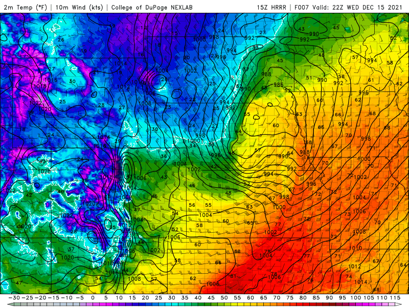
Betcha can't tell where the front/line is on the surface temp map. Just wild:
Posted on 12/15/21 at 10:40 am to LegendInMyMind
This post was edited on 12/15/21 at 10:43 am

Posted on 12/15/21 at 10:41 am to LegendInMyMind
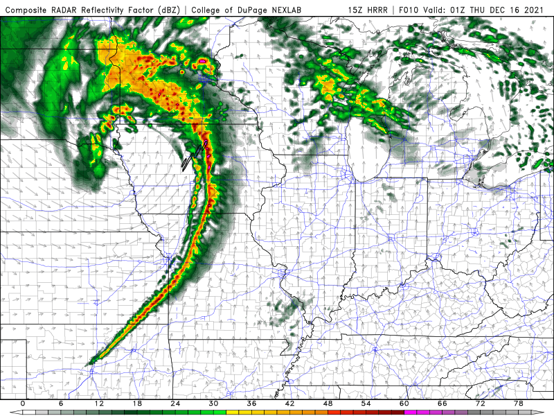
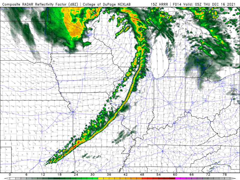
Nasty straight line wind look.
Posted on 12/15/21 at 10:43 am to Roll Tide Ravens
quote:
Nasty straight line wind look.
We can't have this right now. Duke hasn't thought of a rhyming word yet.
Posted on 12/15/21 at 10:53 am to Roll Tide Ravens
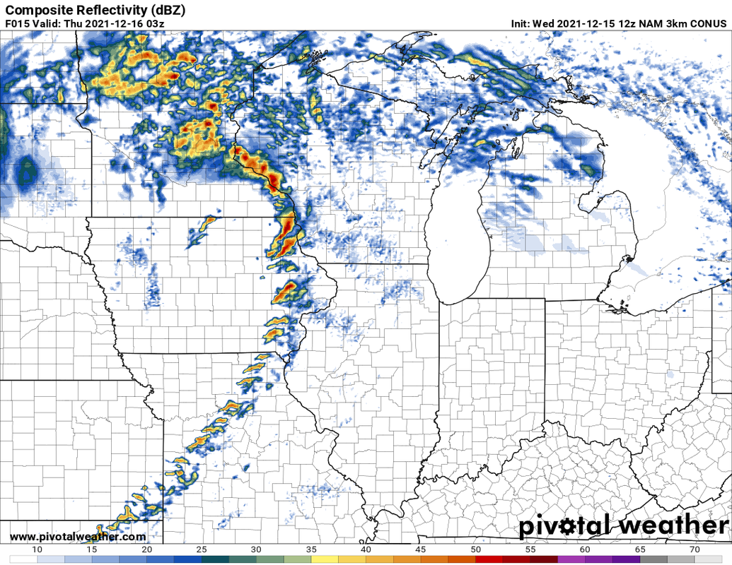
The NAM3K wants doomsday with a line of perfectly segmented supercells. Fortunately, it appears that it had been hitting the sauce.

Posted on 12/15/21 at 10:55 am to LegendInMyMind
I’ll take one derecho plz. Just kidding but we are under a wind advisory overnight tonight. (I’m in north central Ohio close to Erie)
Posted on 12/15/21 at 10:57 am to LegendInMyMind
Torcon used to be legit when Forbes issued it on his own. It was technically separate from TWC but he let them show it obviously cause he worked for them. I’m not sure he is involved now.
The only 10 they’ve ever given, I believe, was 4/27/11.
The only 10 they’ve ever given, I believe, was 4/27/11.
This post was edited on 12/15/21 at 10:59 am
Posted on 12/15/21 at 10:58 am to LegendInMyMind
NWS Louisville has added 2 more drone videos to its YouTube & Twitter pages
Posted on 12/15/21 at 10:59 am to rt3
quote:
NWS Louisville has added 2 more drone videos to its YouTube & Twitter pages
Just checked storm reports for the NWS Huntsville area. They had twenty tornado reports of their own Fri/Sat. I don't know what they've confirmed yet.
This post was edited on 12/15/21 at 11:01 am
Posted on 12/15/21 at 11:03 am to Briella
quote:
The only 10 they’ve ever given, I believe, was 4/27/11.
Yep. The afternoon storms were already firing in MS when they bumped it from a 9 to a 10.
The number 10 was covering my damn house.
Posted on 12/15/21 at 11:03 am to okietiger
quote:
TorCon
Its like the SPC's % chances. Those are for having a tornado coming within 25 miles of a location. Pretty sure TorCon does the same thing but for within 50 miles of a location, hence the higher numbers.
Posted on 12/15/21 at 12:28 pm to Duke
Reed Timmer has made the drive to Iowa and is on FB Live now for today's midwest threat

 Page 84 of 90

Popular
Back to top