- My Forums
- Tiger Rant
- LSU Recruiting
- SEC Rant
- Saints Talk
- Pelicans Talk
- More Sports Board
- Fantasy Sports
- Golf Board
- Soccer Board
- O-T Lounge
- Tech Board
- Home/Garden Board
- Outdoor Board
- Health/Fitness Board
- Movie/TV Board
- Book Board
- Music Board
- Political Talk
- Money Talk
- Fark Board
- Gaming Board
- Travel Board
- Food/Drink Board
- Ticket Exchange
- TD Help Board
Customize My Forums- View All Forums
- Show Left Links
- Topic Sort Options
- Trending Topics
- Recent Topics
- Active Topics
Started By
Message

 2
2

Posted on 8/16/16 at 12:15 am to haikarate
Stonegate Manor off of Germany near roddy
Posted on 8/16/16 at 12:16 am to lyande1
I am at the Cabin Restaurant - 22 and 44
Posted on 8/16/16 at 12:18 am to supernovasky
Geismar - how would parts of it flood? From Alligator Bayou deal or New River from the east?
Posted on 8/16/16 at 12:20 am to haikarate

Posted on 8/16/16 at 12:23 am to GeismarGeauxer
Can I cross the sunshine bridge head up hwy 1 to 190 and get into baker tomorrow morning?
Posted on 8/16/16 at 12:28 am to MrPappagiorgio
I'm off of 44 near 621. Haven't seen any water here, but I'm not far from Black Bayou. Seems like quite a few posters live in this area, stay safe neighbors! 
Posted on 8/16/16 at 12:32 am to ihometiger
quote:
Great site to track the flooding
This is great, thanks!
Posted on 8/16/16 at 12:34 am to NOLA Bronco
quote:
So I saw earlier today water was rising on Bluebonnet between Burbank and Highland. Has that receded at all? Gotten any worse?
Have a couple friends that own Town homes in that Lakes at Bluebonnet.
One has a car parked but has been out of town. Wondered if they should be worried?
So I guess it is still rising. shite.
From only moments ago:

Twitter people seem to be warning it is suddenly rising noticeably.
Not a great picture. Curious if anyone has seen if it has in fact reached those town homes behind where this picture is taken?

Posted on 8/16/16 at 12:37 am to Andy Bernard
quote:
Poor Street Beat having to deal with her. You can see how aggravated he is. Not it is kind of funny
Donna Britt has hands down been the worst of the lot. Street Beat could be asking a serious and good question and then she will jump in and ask something totally off point and asinine. It really is time for her to go.
Having flipped around the stations, I think the best has been Chris Nakamoto. He has busted his arse and been in tons of different places covering things. Honorable mention goes to Michael Cauble, who has shown us that a sports dude can be a news dude also and do a good job.
Posted on 8/16/16 at 12:41 am to LaBR4
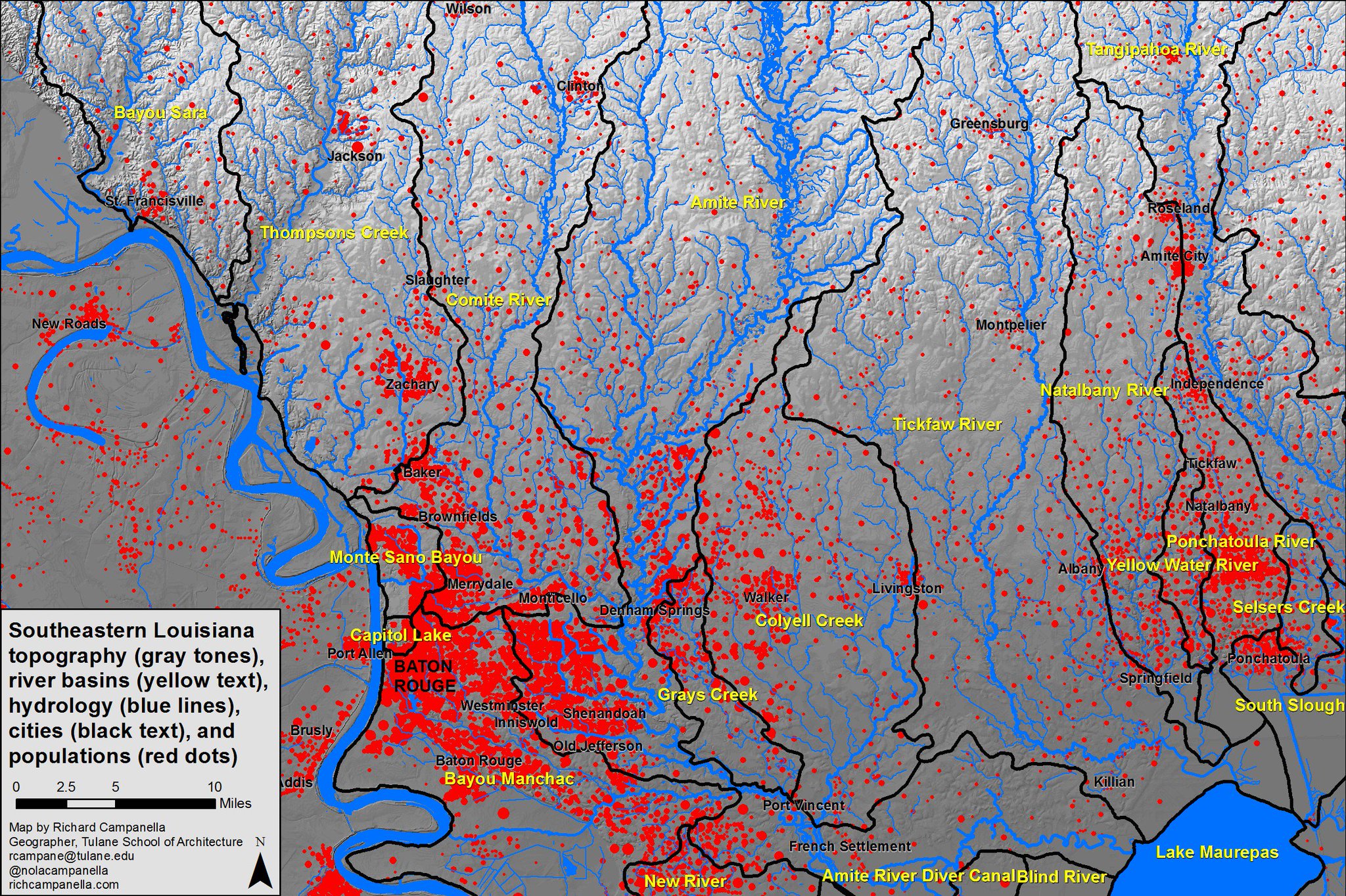

Vertically exaggerated oblique view of Amite River Basin (upper center); Baton Rouge left-cent; Miss River low-left.
This post was edited on 8/16/16 at 12:43 am
Posted on 8/16/16 at 12:45 am to supernovasky
Hey Supernova, just wanted to again thank you for all the help you've been the last few days. You've saved people's lives and that isn't an exaggeration. I would love to buy you some whiskey or give you some bottles or samples of whatever you want. My email is David@bourbonbr.com Please email me later this week and we can figure out something. I'll take you to the Cove, Lock & Key, Olive or Twist, or wherever else you want to go. I can do samples of some great bourbons and whiskeys if you're too busy the next few weeks.
You've done a great service to the people of BR and please let me return the favor!
You've done a great service to the people of BR and please let me return the favor!
Posted on 8/16/16 at 12:48 am to LaBR4
Water is not crossing from the East side over Airline into the west side, the traffic camera can back that up. Currently the water on the East side of Airline (Bayou Francois) is about 5 - 6 ft from reaching the top of Airline at the nearest point. The water between the tracks and airline is coming from the sewers or something esle because north of R & Bs isn't fully inundated with water. There is alot of water on the west side of Airline going from 61 junk st. up to the Vo-tech school, but I don't know where it's originating from.
Not much standing water to be seen on the south side of Hwy 22 on the west side of the tracks. A little bit of water can be found on Brittany st. which is on the north side of 22.
Not much standing water to be seen on the south side of Hwy 22 on the west side of the tracks. A little bit of water can be found on Brittany st. which is on the north side of 22.
Posted on 8/16/16 at 12:51 am to Sorrento Muddbugs
good info - thanks. I am at the Cabin at 44 and 22
Posted on 8/16/16 at 12:53 am to NOLA Bronco

Kleinpeter gauge still showing the water is rising now at 11.34 ft

Posted on 8/16/16 at 12:54 am to ihometiger
Crest?
Posted on 8/16/16 at 12:58 am to Paul Allen
quote:
Crest?
Nope its been continually rising 1/10th of an inch every 15 minutes.
Posted on 8/16/16 at 12:59 am to ihometiger
So as someone who doesn't live in LA, what caused this? We've had hurricanes that didn't have this much flooding. Was it drainage failure? Hard to believe it's just straight rain.
Posted on 8/16/16 at 1:01 am to ihometiger
facebook friend
quote:
South Long Oaks Subdivision is Taking on lots of water people are evacuating as we speak ! Water is crossing Weber City Road rapidly .
Posted on 8/16/16 at 1:02 am to DupontsCircle
Rain.
LINK
LINK

 Page 408 of 472

Popular
Back to top