- My Forums
- Tiger Rant
- LSU Recruiting
- SEC Rant
- Saints Talk
- Pelicans Talk
- More Sports Board
- Winter Olympics
- Fantasy Sports
- Golf Board
- Soccer Board
- O-T Lounge
- Tech Board
- Home/Garden Board
- Outdoor Board
- Health/Fitness Board
- Movie/TV Board
- Book Board
- Music Board
- Political Talk
- Money Talk
- Fark Board
- Gaming Board
- Travel Board
- Food/Drink Board
- Ticket Exchange
- TD Help Board
Customize My Forums- View All Forums
- Show Left Links
- Topic Sort Options
- Trending Topics
- Recent Topics
- Active Topics
Started By
Message
re: Sunday Weather Thread
Posted on 5/2/21 at 6:48 pm to Bobby OG Johnson

Posted on 5/2/21 at 6:48 pm to Bobby OG Johnson
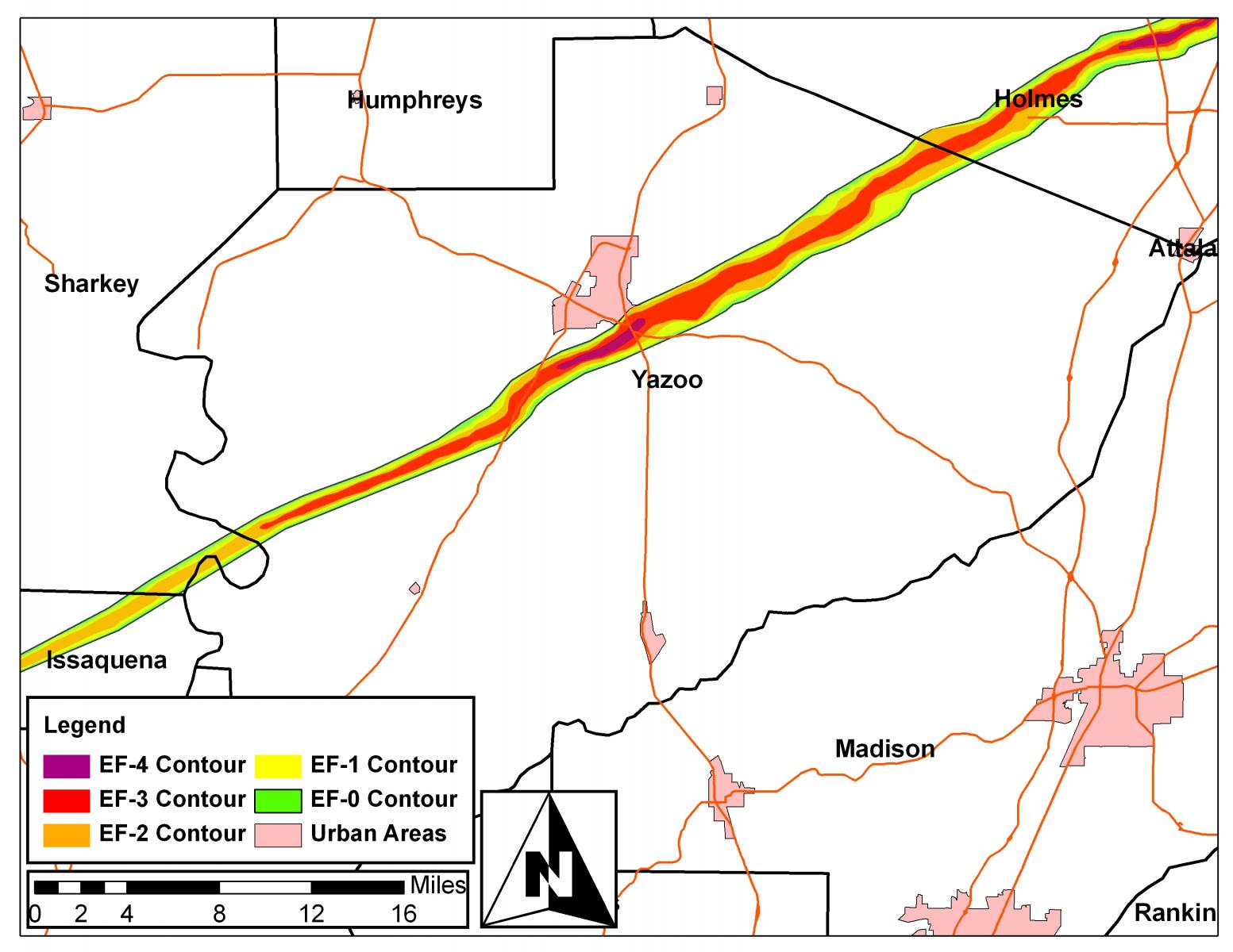
Seems like the storm that went through Yazoo City is ramping back up again. Couplet looks a little better.
 0
0


Posted on 5/2/21 at 6:48 pm to LegendInMyMind
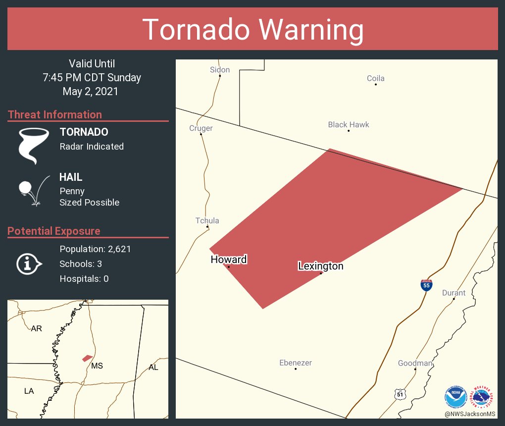
The storm right north of the yazoo cell needs to be warned. It isn’t yet for some reason

Posted on 5/2/21 at 6:48 pm to LegendInMyMind
quote:
so I can't trust Zack now?
I don't know who Zack is, but NO was never really in the Slight Risk area, as evidenced by the actual SPC Convective Outlook risk map Bobby posted.
dude, I am talking about the info we are getting from local Mets, not TD.
Posted on 5/2/21 at 6:49 pm to LegendInMyMind
Looks like a similar path through the south to SE of Yazoo as the 2010 one but hopefully nowhere near as destructive.
Posted on 5/2/21 at 6:50 pm to The Boat
quote:
Always seems like the overlooked slight days produce worse tornadoes than hyped days.
To be fair, SPC gave the caveat of saying today would rely heavily on Meso features.
Posted on 5/2/21 at 6:51 pm to t00f
quote:
local Mets, not TD.
TD Mets >>>>> local and national Mets
Posted on 5/2/21 at 6:51 pm to NorthEndZone
The NWS extended the warning on the former Yazoo City storm. NWS still calling it a confirmed tornado.
This post was edited on 5/2/21 at 6:53 pm

Posted on 5/2/21 at 6:51 pm to LegendInMyMind
Posted on 5/2/21 at 6:52 pm to Bobby OG Johnson
About frickin time. That cell looked good for a long time with no tornado warning.

Posted on 5/2/21 at 6:52 pm to Bobby OG Johnson
Posted on 5/2/21 at 6:53 pm to t00f
quote:
dude, I am talking about the info we are getting from local Mets, not TD.
I know. And I'm talking about the National Weather Service Storm Prediction Center.
It is a problem, though. Back in March, I watched the ABC 33/40 guys put out a Day 4 Slight Risk graphic that looked exactly like the SPC 3-Day outlook risk assessment....same colors, same wording, similar graphic. Nevermind that the SPC doesn't do Risk Level assessment beyond day 3.
This post was edited on 5/2/21 at 6:54 pm
Posted on 5/2/21 at 6:53 pm to Bobby OG Johnson
Posted on 5/2/21 at 6:54 pm to tgrbaitn08
quote:
TD Mets >>>>> local and national Mets
No one said that.
I'm comparing local mets to mets at the National Weather Service Storm Prediction Center.
This post was edited on 5/2/21 at 6:55 pm
Posted on 5/2/21 at 6:54 pm to Bobby OG Johnson
Reed 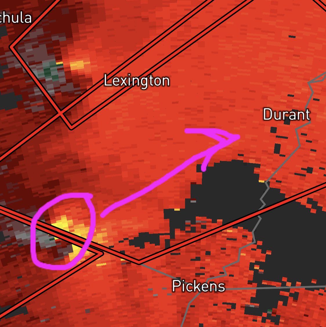
Posted on 5/2/21 at 6:54 pm to LegendInMyMind
The debris ball is back on the yazoo cell
Posted on 5/2/21 at 6:55 pm to tgrbaitn08
quote:
local Mets, not TD.
TD Mets >>>>> local and national Mets
I love TD and the knowledge but I also have to rely on these dude that do this for a living.
Posted on 5/2/21 at 6:55 pm to LegendInMyMind
quote:
No one said that.
I said that
Posted on 5/2/21 at 6:56 pm to t00f
quote:
I love TD and the knowledge but I also have to rely on these dude that do this for a living.
Peej has been watching the news for 40 years....he knows what he's talking about
Posted on 5/2/21 at 6:56 pm to t00f
quote:
I love TD and the knowledge but I also have to rely on these dude that do this for a living.
Good. Also realize that there is a very real pecking order among those guys, as well.
Posted on 5/2/21 at 6:57 pm to t00f

 Page 4 of 14

Popular
Back to top