- My Forums
- Tiger Rant
- LSU Recruiting
- SEC Rant
- Saints Talk
- Pelicans Talk
- More Sports Board
- Fantasy Sports
- Golf Board
- Soccer Board
- O-T Lounge
- Tech Board
- Home/Garden Board
- Outdoor Board
- Health/Fitness Board
- Movie/TV Board
- Book Board
- Music Board
- Political Talk
- Money Talk
- Fark Board
- Gaming Board
- Travel Board
- Food/Drink Board
- Ticket Exchange
- TD Help Board
Customize My Forums- View All Forums
- Show Left Links
- Topic Sort Options
- Trending Topics
- Recent Topics
- Active Topics
Started By
Message
re: Southern U.S. Severe Weather & Flooding: April 8-11, 2024
Posted on 4/8/24 at 3:40 pm to Roll Tide Ravens

Posted on 4/8/24 at 3:40 pm to Roll Tide Ravens

 1
1

Posted on 4/8/24 at 3:59 pm to Roll Tide Ravens
I could have predicted this weather way before now. Even on Thursday winds are supposed to be brutal. 
I had planned to be fishing.
I had planned to be fishing.
This post was edited on 4/8/24 at 4:01 pm
Posted on 4/8/24 at 4:00 pm to Roll Tide Ravens
Long as it’s clear from Augusta ga by Friday
Posted on 4/8/24 at 4:05 pm to Jack Daniel
quote:
I don’t see anything that’s thread worthy
You know, this gets said in some fashion in every single thread about a weather event. It doesn't matter the potential ceiling of an event, some jackass will come along and say something like this. It was said about the setup that led to the Mayfield, KY tornado on the first page. That wound up being one of the worst Winter tornado outbreaks on record.
It just never fails, and I find that humorous.
Posted on 4/8/24 at 4:21 pm to Roll Tide Ravens
Synoptically speaking, the position of the surface low Wednesday into Thursday is just about classic for a Dixie Alley tornado outbreak. However, it looks like instability will be a lacking ingredient for such an outbreak.

Posted on 4/8/24 at 4:55 pm to LegendInMyMind
All I know is it seems like it's been windy for a damn week
I finally was able to burn off some stuff this afternoon, even before lunch was too gusty
I finally was able to burn off some stuff this afternoon, even before lunch was too gusty
Posted on 4/8/24 at 6:15 pm to Wishnitwas1998
They have a legit hailer West of Nashville. Hail spike and warned for ping pong balls.
Posted on 4/8/24 at 6:18 pm to R11
quote:
Long as it’s clear from Augusta ga by Friday
Rain in Alabama on Thursday often means rain in Georgia on Friday

Posted on 4/8/24 at 7:14 pm to LegendInMyMind
I just want to know if it’s going to rain until Thursday. Getting old.

Posted on 4/8/24 at 7:16 pm to LSUGrrrl
Weds is the crappy day in LA.
Posted on 4/8/24 at 7:18 pm to LSUGrrrl
quote:
I just want to know if it’s going to rain until Thursday.
Yes.
Posted on 4/8/24 at 7:37 pm to LegendInMyMind

Posted on 4/8/24 at 8:05 pm to Roll Tide Ravens
quote:
DiscussingFilm
@DiscussingFilm
‘TWISTERS’ booths will be placed in theaters this Summer where customers can stand & have air blown all over them.


Posted on 4/8/24 at 8:26 pm to LegendInMyMind
quote:
Well, that's dumb.
Well hold on now we need some specifics,
These booths......someone will blow me in them? What kind of someone??
This post was edited on 4/8/24 at 8:27 pm

Posted on 4/8/24 at 9:06 pm to Chingon Ag
quote:
west/central North Texas
So is this like a 10,000 sq mile area?
Posted on 4/8/24 at 10:34 pm to dkreller
Strong storm moving through Pike County MS. Lots of lightning/wind and heavy rain. Lost power but not sure if we regained or generator kicked on
Posted on 4/9/24 at 12:34 am to Mr Roboto
Saw that nasty looking Hook on Radar as it was crossing East Central LA earlier. Looked pretty intense!
Posted on 4/9/24 at 1:38 am to RBTiger
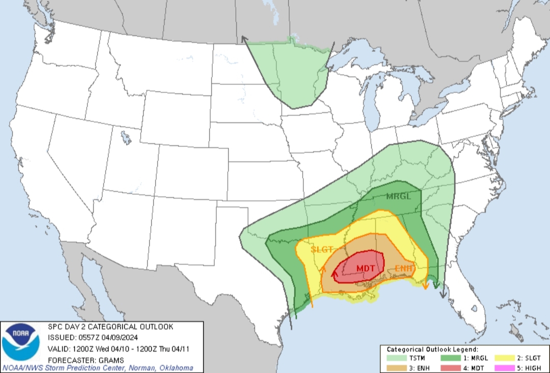
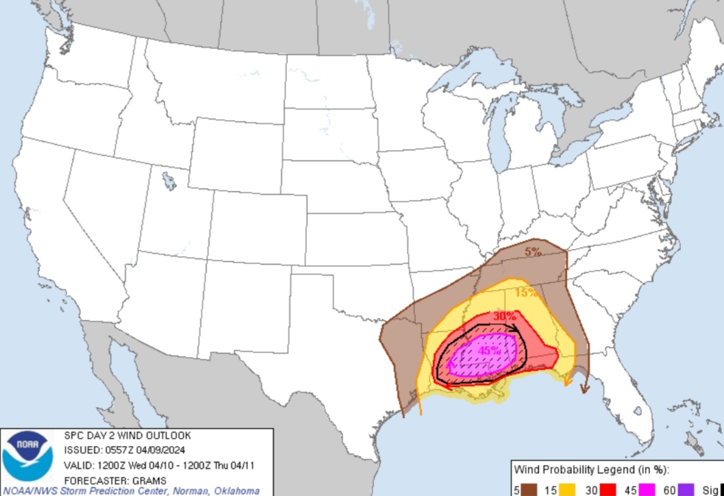
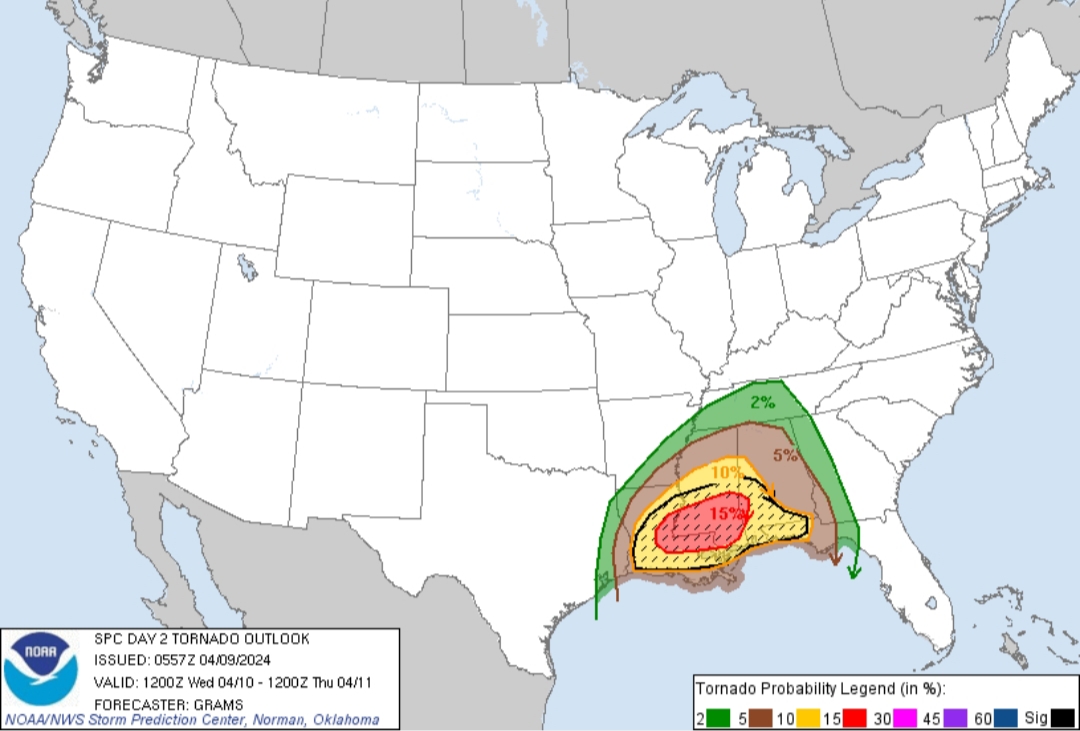
Moderate risk is up for Wednesday with the 1am update. 15% hatched area for tornado risk and a 45% hatched area for wind.
Posted on 4/9/24 at 1:45 am to LegendInMyMind
SPC AC 090557
Day 2 Convective Outlook NWS Storm Prediction Center Norman OK 1257 AM CDT Tue Apr 09 2024
Valid 101200Z - 111200Z
...THERE IS A MODERATE RISK OF SEVERE THUNDERSTORMS IN CENTRAL AND SOUTHERN MS...EASTERN LA...AND SOUTHWEST AL...
...SUMMARY... Numerous to widespread severe thunderstorms are probable beginning Wednesday morning across parts of the central Gulf Coast States. These will include potential for both many tornadoes, some of which should be strong (EF2-EF3 caliber), and widespread damaging wind swaths with embedded significant severe gusts.
...Synopsis... Primary feature of interest will be a southern-stream shortwave trough over west TX at 12Z Wednesday. This shortwave impulse should begin to phase with a northern-stream wave digging into the Upper Midwest, yielding a full-latitude amplified trough near the MS Valley by 12Z Thursday. This will result in substantial flow amplification through the troposphere, commencing by Wednesday morning as a surface cyclone gradually deepens northeastward from east TX towards the Lower OH Valley.
...Central Gulf Coast/Deep South... A swath of numerous to widespread severe storms appears increasingly likely on Wednesday morning to afternoon, highlighted within the level 3-4/ENH-MDT risks. A nocturnal tornado/wind threat should persist into Wednesday night across south AL, the FL Panhandle, and southwest GA.
An MCS is expected to be ongoing from the Sabine to Lower MS Valleys vicinity at 12Z Wednesday, with the southern portion potentially already producing severe wind and tornadoes. Guidance is more consistent with the indication of a plume of moderately steep mid-level lapse rates ahead of this activity, emanating around the MCS from the northwest Gulf. A renewed surge of rich western Gulf moisture is progged to advect north-northeast just ahead of the morning activity across LA, yielding moderate buoyancy across convection-free areas of LA into south MS.
Convective intensity should diurnally increase through late morning/midday within already strong low-/deep-layer shear. The initial thermodynamic environment coupled with further strengthening of tropospheric wind fields should yield potential for an intense QLCS spreading east-northeast into the afternoon. Embedded supercells, with a possibility for semi-discrete ones just ahead of the line along its southern flank, in addition to small-scale bowing segments will be conducive to tornadoes and damaging wind swaths. Primary uncertainty is just how far north-northeast this severe MCS will extend, as both weaker mid and low-level lapse rates with northeast extent and deep convection regenerating southwestward towards the larger buoyancy plume, may yield a relatively pronounced northern cutoff to the more widespread severe threat.
A tornado and severe wind threat should linger into Wednesday evening/night, at least along the northeast Gulf coast region, with regenerative offshore supercells moving inland. Guidance is consistent in suggesting further increases of low-level shear/hodograph curvature into the FL Panhandle vicinity through 12Z Thursday, supporting a nocturnal strong tornado risk.
...Ark-La-Tex/Ark-La-Miss to the TN Valley... A separate area of severe storms, primarily in the form of large hail initially, should develop along a portion of the Red River Valley near the Ark-La-Tex. This activity will be supported by a plume of steep mid-level lapse rates near the cold-core region of the mid-level low, and the northwest periphery of the residual Gulf low-level moisture plume that will likely be modified by the extensive MCS near the central Gulf Coast.
Guidance has shown more variability with timing the east and eventual northeast pivot of the mid-level low on Wednesday night, yielding uncertainty in how far northeast at least a low-probability severe threat will extend. There will be an attempt at overnight airmass recovery northward from the central Gulf Coast to the TN Valley in the wake of the large early-day MCS. Low-level shear profiles will be supportive of rotating storms into early Wednesday, with lower-probability tornado/wind threats.
..Grams.. 04/09/2024
CLICK TO GET WUUS02 PTSDY2 PRODUCT
NOTE: THE NEXT DAY 2 OUTLOOK IS SCHEDULED BY 1730Z
This post was edited on 4/9/24 at 1:49 am

 Page 2 of 41

Popular
Back to top