- My Forums
- Tiger Rant
- LSU Recruiting
- SEC Rant
- Saints Talk
- Pelicans Talk
- More Sports Board
- Coaching Changes
- Fantasy Sports
- Golf Board
- Soccer Board
- O-T Lounge
- Tech Board
- Home/Garden Board
- Outdoor Board
- Health/Fitness Board
- Movie/TV Board
- Book Board
- Music Board
- Political Talk
- Money Talk
- Fark Board
- Gaming Board
- Travel Board
- Food/Drink Board
- Ticket Exchange
- TD Help Board
Customize My Forums- View All Forums
- Show Left Links
- Topic Sort Options
- Trending Topics
- Recent Topics
- Active Topics
Started By
Message
 1
1

Posted on 1/10/21 at 7:40 am to Duke
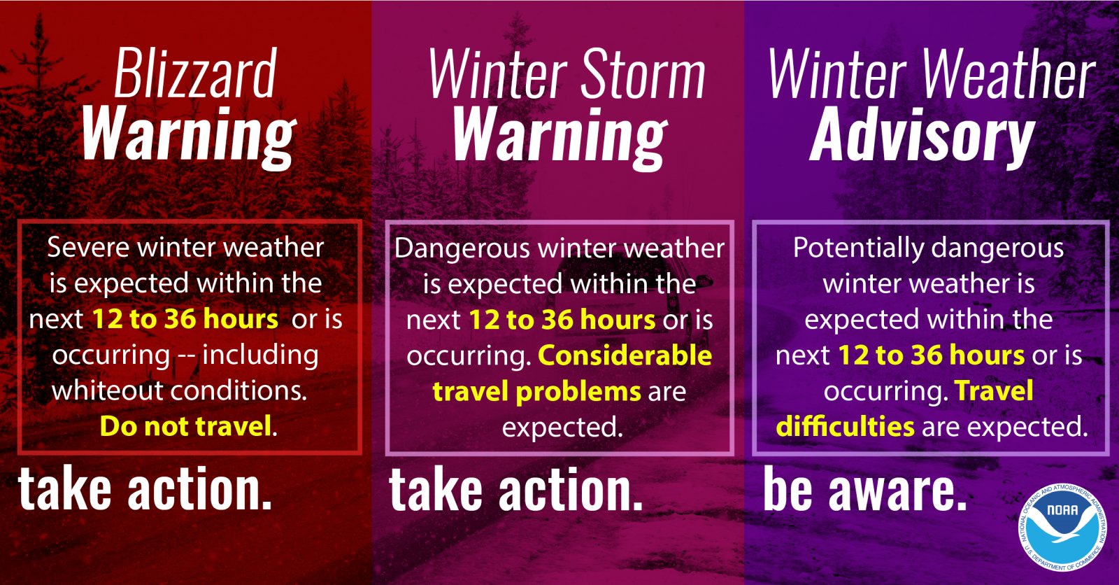
Alexandria added to a winter weather advisory 
Posted on 1/10/21 at 7:41 am to Bigfishchoupique
It's going to disappoint a lot of people in the SE part of the state today.
ETA:
ETA:
This post was edited on 1/10/21 at 7:42 am
Posted on 1/10/21 at 7:47 am to Bigfishchoupique
quote:
I am near a Houma and looking at TWC Radar And there is blue stuff on the radar. What am I seeing,is it snow flurries ?
Is the snow blue outside?
Just kidding.
I am near the Houma airbase. It is still dry. Temperature outside on my car says 40.
I wonder if TPSO will need to deploy Mr. Plow on the bridges.
This post was edited on 1/10/21 at 7:49 am
Posted on 1/10/21 at 7:47 am to rt3
Mikulas from around 5 AM
quote:
Scattered light rain has developed ahead of that lead wave I was talking about. Dry air should eat a lot of this, but light snow or sleet could mix in for a little morning surprise in spots. It’s of course not a surprise to you because we talked about this yesterday. Again, this is the appetizer.
My hazy glance at the models before I go back for round two of sleep shows improving chances for snow a bit further south. I’ll get into details in my long post this morning, but I’m more confident that we will see some snow, and probably at least light accumulation in areas like Leesville and Alexandria. Some of the models show some pretty wild scenarios, but I’m half asleep. I’ll dig into this and have something out by mid morning. There are winter storm warnings over a large chunk of North LA, with a winter weather advisory that includes Rapides, Vernon, Avoyelles, Grant, LaSalle, Catahoula, and Concordia Parishes for “up to 2 inches of snow”. It’s not impossible that some spots see more than this. Getting a little giddy over here.
This post was edited on 1/10/21 at 7:48 am
Posted on 1/10/21 at 7:51 am to rt3
TWC has storm chaser Charles Peek in Abilene, Texas and it looks like a winter wonderland there
Posted on 1/10/21 at 8:19 am to Duke
quote:
URGENT - WINTER WEATHER MESSAGE
National Weather Service Lake Charles LA
355 AM CST Sun Jan 10 2021
...Some light accumulations of snow and sleet will be possible in
portions of the region overnight into Monday morning...
.A potent winter storm will impact the region from late Sunday
through early Monday. Precipitation in the southern half of the
region is expected to remain a cold rain, but further north snow
and sleet is expected to mix in with the rain, potentially
becoming predominately snow at times. As such, some snow
accumulations will be possible in east central TX into central LA.
The sharp gradient for the rain/snow line may result in
accumulations from as little as a trace to up to around 2 inches.
Vernon-Rapides-Avoyelles-Tyler-Northern Jasper-Northern Newton-
Including the cities of Fort Polk, Pickering, Leesville, Slagle,
Alexandria, Pineville, Effie, Marksville, Bunkie, Cottonport,
Simmesport, Mansura, Town Bluff, Fred, Hillister, Ivanhoe,
Spurger, Warren, Woodville, Holly Springs, Jasper, Kirbyville,
Magnolia Springs, Mt. Union, Roganville, Burkeville, Farrsville,
Jamestown, Newton, Wiergate, Bleakwood, and Call
355 AM CST Sun Jan 10 2021
...WINTER WEATHER ADVISORY IN EFFECT FROM 2 PM THIS AFTERNOON TO
8 AM CST MONDAY...
* WHAT...Wet snow expected. Total snow accumulations of a trace up
to around two inches possible.
* WHERE...Portions of central Louisiana and southeast Texas.
* WHEN...From 2 PM this afternoon to 8 AM CST Monday.
* IMPACTS...Wet snow and sleet may result in hazardous and slick
road conditions, especially on elevated surfaces and bridges,
and could impact the morning commute.
PRECAUTIONARY/PREPAREDNESS ACTIONS...
Slow down and use caution while traveling.
In Louisiana, call 511 for road information. In Texas, visit
www.drivetexas.org for road information.
&&
$$

Posted on 1/10/21 at 8:19 am to rt3
Holy shite winter storm warning prepare thine anine
Posted on 1/10/21 at 8:22 am to Tarps99
quote:.
Is the snow blue outside?
Posted on 1/10/21 at 8:23 am to The Boat
in its infinite wisdom... TWC has dubbed this Winter Storm Lana


Posted on 1/10/21 at 8:25 am to Tarps99
quote:
I wonder if TPSO will need to deploy Mr. Plow on the bridges.

Posted on 1/10/21 at 8:25 am to rt3
Natchitoches is now a winter storm warning. Snow ball fight at work tomorrow morning

Posted on 1/10/21 at 8:25 am to rt3
Posted on 1/10/21 at 8:26 am to The Boat
I'm in Metairie and I just went outside to get something out of my car and there were a few flakes of snow/sleet that I saw. Nothing heavy, just a few flakes.
Edit: just y st went outside and looked again and nada.
Edit: just y st went outside and looked again and nada.
This post was edited on 1/10/21 at 8:32 am
Posted on 1/10/21 at 8:28 am to doublecutter
That’s just leftovers from the party at Big Lee’s house last night
Posted on 1/10/21 at 8:35 am to bakersman
quote:
Natchitoches is now a winter storm warning. Snow ball fight at work tomorrow morning
the whole NWS Shreveport coverage area is under some kind of winter weather alert

Posted on 1/10/21 at 8:35 am to doublecutter
I’m in Miami and there’s a bunch of flakes coming down. no accumulation yet
Posted on 1/10/21 at 8:37 am to rt3
Of all the departments in South Louisiana, Terrebonne parish is the only one with snow plows.
They got them for other reasons mainly to move hurricane debris from the roadway.
When it snowed back in 2017 or 2018, they used them on the bridges in Terrebonne and then used them in Lafourche to get the LA 1 Leeville bridge open.
They got them for other reasons mainly to move hurricane debris from the roadway.
When it snowed back in 2017 or 2018, they used them on the bridges in Terrebonne and then used them in Lafourche to get the LA 1 Leeville bridge open.
Posted on 1/10/21 at 8:45 am to Tarps99
Posted on 1/10/21 at 8:46 am to Tarps99
quote:
Meteorologist Nick Mikulas
I’ll be updating in the next hour or so. If anyone around Jasper Texas could give me a precipitation type report, that would be fantastic. Anywhere in that general area. It’s not impossible that this will produce some form of precipitation in parts of Beauregard and Vernon Parish in the next hour.

 Page 19 of 33

Popular
Back to top