- My Forums
- Tiger Rant
- LSU Recruiting
- SEC Rant
- Saints Talk
- Pelicans Talk
- More Sports Board
- Coaching Changes
- Fantasy Sports
- Golf Board
- Soccer Board
- O-T Lounge
- Tech Board
- Home/Garden Board
- Outdoor Board
- Health/Fitness Board
- Movie/TV Board
- Book Board
- Music Board
- Political Talk
- Money Talk
- Fark Board
- Gaming Board
- Travel Board
- Food/Drink Board
- Ticket Exchange
- TD Help Board
Customize My Forums- View All Forums
- Show Left Links
- Topic Sort Options
- Trending Topics
- Recent Topics
- Active Topics
Started By
Message
re: Severe Weather Thread: 4/17 --Extra Bonus Easter Edition-- North LA and Northshore
Posted on 4/17/22 at 7:02 pm to LegendInMyMind
Posted on 4/17/22 at 7:02 pm to LegendInMyMind
Like everything else today though, they tend to broaden out pretty quickly which does make sense with the anemic low level winds.
 3
3

Posted on 4/17/22 at 7:08 pm to Duke
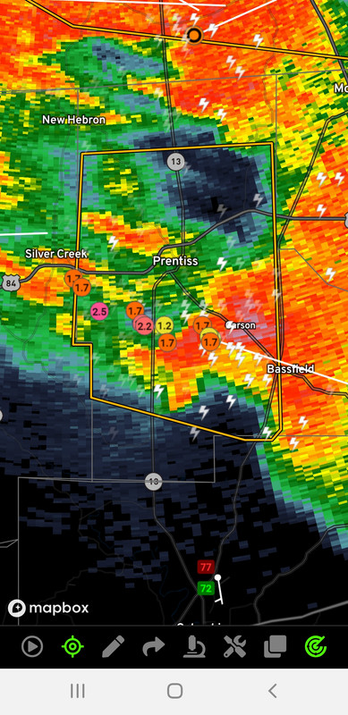
Probably some decent hail with that coming into Bassfield.
Posted on 4/17/22 at 7:09 pm to Duke
quote:
Like everything else today though, they tend to broaden out pretty quickly which does make sense with the anemic low level winds.
Overall storm motion isn't very helpful either.

Posted on 4/17/22 at 7:11 pm to Duke
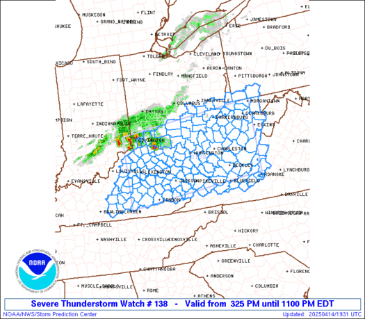
Severe Thunderstorm Watch for EBR and surrounding parishes.
Posted on 4/17/22 at 7:12 pm to Duke
Omega lets you track the Nexrad hail history.
Posted on 4/17/22 at 7:12 pm to udtiger
Posted on 4/17/22 at 7:19 pm to Duke
Pretty good gust front back behind those leading cells. 70mph winds.

Posted on 4/17/22 at 7:22 pm to Duke
I’m really surprised JAN hasn’t issued a tornado warning for the cell near Bassfield, considering some of the other warnings they’ve issued during the last few events.
Posted on 4/17/22 at 7:26 pm to Roll Tide Ravens
By the way, I remember a big EF-4 tornado hitting the area from Bassfield up to Seminary on Easter 2020.
Posted on 4/17/22 at 7:27 pm to Roll Tide Ravens
Now we have a tornado warning on the Bassfield storm.
Posted on 4/17/22 at 7:27 pm to Roll Tide Ravens
The hail North of Hattiesburg has picked up.
Posted on 4/17/22 at 7:43 pm to LegendInMyMind
Big hail NW of Woodville, LA.
Posted on 4/17/22 at 7:54 pm to LegendInMyMind
Posted on 4/17/22 at 8:00 pm to Roll Tide Ravens
I bet them calling it in is what triggered the warning. It was a little tornadolette.
Posted on 4/17/22 at 8:04 pm to Roll Tide Ravens
Embedded rotation near Woodville, LA is interesting.

Posted on 4/17/22 at 8:05 pm to Roll Tide Ravens
Wife said the power is starting to flicker in Hattiesburg
Posted on 4/17/22 at 8:11 pm to im4LSU
Tornado Warning North of Laurel.
Posted on 4/17/22 at 8:12 pm to LegendInMyMind
Yep, Sandersville getting the business
Posted on 4/17/22 at 8:14 pm to im4LSU
Hattiesburg is about to get the gust front with 60-70mph winds.
Posted on 4/17/22 at 8:16 pm to LegendInMyMind
I just told my wife the same thing
I’m stuck in the middle of the fricking gulf too
I’m stuck in the middle of the fricking gulf too
This post was edited on 4/17/22 at 8:18 pm

 Page 78 of 81

Popular
Back to top