- My Forums
- Tiger Rant
- LSU Recruiting
- SEC Rant
- Saints Talk
- Pelicans Talk
- More Sports Board
- Coaching Changes
- Fantasy Sports
- Golf Board
- Soccer Board
- O-T Lounge
- Tech Board
- Home/Garden Board
- Outdoor Board
- Health/Fitness Board
- Movie/TV Board
- Book Board
- Music Board
- Political Talk
- Money Talk
- Fark Board
- Gaming Board
- Travel Board
- Food/Drink Board
- Ticket Exchange
- TD Help Board
Customize My Forums- View All Forums
- Show Left Links
- Topic Sort Options
- Trending Topics
- Recent Topics
- Active Topics
Started By
Message
re: Severe Weather Thread: 4/17 --Extra Bonus Easter Edition-- North LA and Northshore
Posted on 4/15/22 at 9:49 pm to LegendInMyMind
Posted on 4/15/22 at 9:49 pm to LegendInMyMind
I don't think I have ever seen a chaser in the field with a still-warned cell in their area immediately take to social media in an attempt to discredit the storm.
That type stuff usually comes by staying on the storm and providing info. He was late to the party, couldn't or didn't want to catch the storm, so he immediately started tweeting.
That type stuff usually comes by staying on the storm and providing info. He was late to the party, couldn't or didn't want to catch the storm, so he immediately started tweeting.
This post was edited on 4/15/22 at 9:51 pm
 0
0


Posted on 4/15/22 at 9:52 pm to Duke
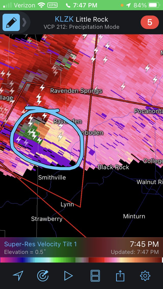
Velocity and CC indicated very strong straight line winds. CC had a bowing crescent shape right on the leading edge.
Posted on 4/15/22 at 9:55 pm to The Boat
quote:
Velocity and CC indicated very strong straight line winds. CC had a bowing crescent shape right on the leading edge.
That's what I'm thinking too.
Posted on 4/15/22 at 9:57 pm to LegendInMyMind
LINK
here is a link to what came through Tyler texas… came down chilton …. hit the brick street district bad also..I use to live next to a few houses in the article so know the area well….trees are extremely old .. area built in 40-50s…
here is a link to what came through Tyler texas… came down chilton …. hit the brick street district bad also..I use to live next to a few houses in the article so know the area well….trees are extremely old .. area built in 40-50s…
Posted on 4/15/22 at 9:58 pm to The Boat
CC was garbage most of the time. The Springfield radar was down for a 20+ minute stretch, and has had problems for a week or more now. Velocity on the lowest tilt was practically useless because the Memphis radar was so far away.
I don't fault anyone for making any decision on the early life of that storm with the crap radar presentation.
No chasers in the area either. The first report was from a trained spotter. The second was from law enforcement. And....it is night. This is possibly the worst scenario you could ask for as far as ground truth is concerned.
Add in the monster hail mucking up the works and it is that much worse.
This post was edited on 4/15/22 at 10:01 pm
Posted on 4/15/22 at 10:01 pm to LegendInMyMind
quote:
CC was garbage most of the time.
You could tell what the leading edge bowing was
Posted on 4/15/22 at 10:05 pm to LegendInMyMind
I understand the difficulty and glad I didnt have to make that decision tonight but I think we're going to find strong wind and maybe EF0 in spots.
Based on the damage reports we have now.
I was thinking for a good 15 minutes before they called it "radar indicated" it looked more like wind than tornado but when multiple spotters who should be able to tell a scud from a tor are reporting a tornado you're gonna side with that. Especially since it was such a radar holem
Posted on 4/15/22 at 10:07 pm to Duke
The cell transitioned and the bowing/straight line winds developed after the tornado damage reports ended. NWS went to radar indicated when the bowing cranked up.
Posted on 4/15/22 at 10:10 pm to The Boat
Anymore threats for the 4-5am timeframe. Looks like some red on my future cast.
Posted on 4/15/22 at 10:17 pm to The Boat
Yeah. The first PDS included Imboden, AR. Walnut Ridge is 15 miles as the crow flies from Imboden. The first tornado reports would have come from West of Cherokee village. That's alot of miles given what that storm was doing at the time.
The initial PDS was likely issued on reports from an area 20+ miles away. I think by the time it made it to Walnut Ridge (which was also putting it in better radar range to Memphis) it had transitioned to a wind event.
The initial PDS was likely issued on reports from an area 20+ miles away. I think by the time it made it to Walnut Ridge (which was also putting it in better radar range to Memphis) it had transitioned to a wind event.
This post was edited on 4/15/22 at 10:30 pm
Posted on 4/15/22 at 10:26 pm to The Boat
quote:
The cell transitioned and the bowing/straight line winds developed after the tornado damage reports ended. NWS went to radar indicated when the bowing cranked up.
I think it went wind event before that, like somewhere between Imboden and Walnut Ridge.
I see this on radar, know the elevation I'm getting the return from and have eyes on the ground saying there's a tor I believe it. I'm pretty sure a couple of the reports saying there was a tornado on the ground were from around this area.
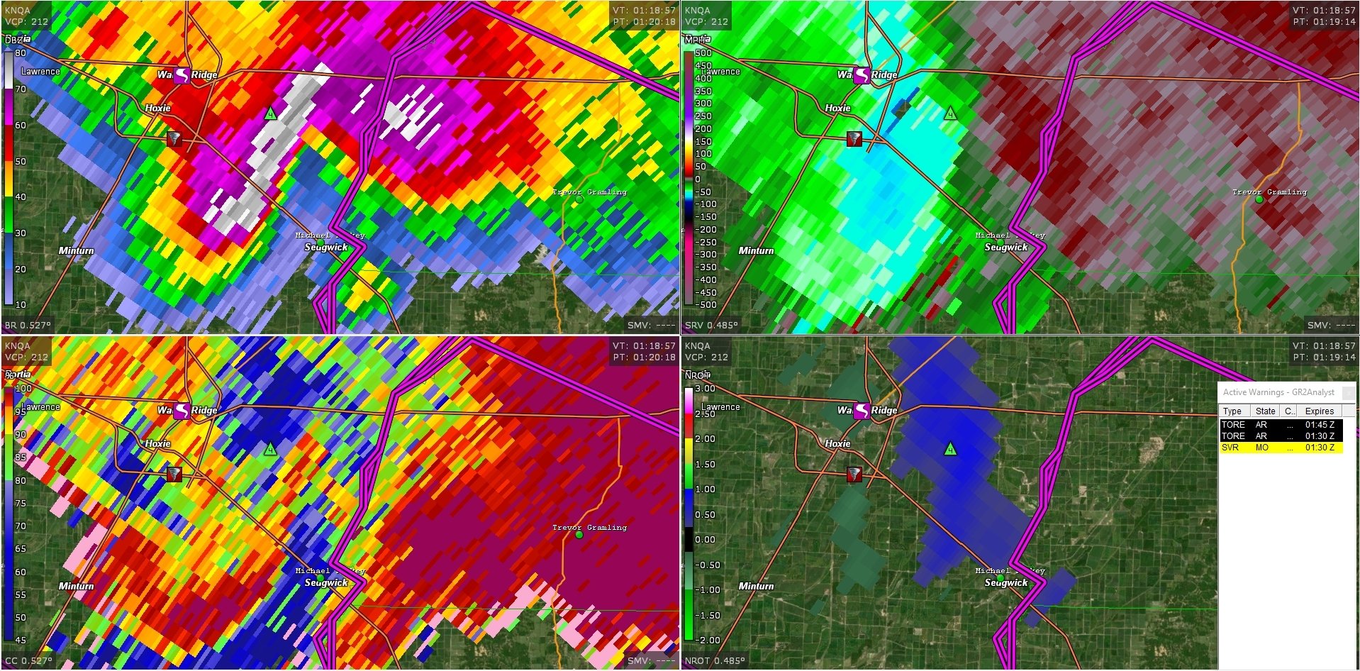
This though, I really have some doubts. Maybe right there northwest of Sedgwick, it's in the inflow notch but still looks more windy than anything. Well that and throwing softballs.
Posted on 4/15/22 at 10:34 pm to Duke
I didn't screen shot Velocity at the time you posted, but that is what I was thinking of with how far out it was. The hail was really messing with CC returns then, too. I don't think anyone could look at that storm on the Memphis radar when it was West of Walnut Ridge and say anything definitive.
When the spotter reports, good or bad, kept coming in, you have to issue that warning. I'm undecided if I agree that it ever should have been a PDS Warning. I just don't know.
When the spotter reports, good or bad, kept coming in, you have to issue that warning. I'm undecided if I agree that it ever should have been a PDS Warning. I just don't know.
Posted on 4/15/22 at 10:35 pm to LegendInMyMind
Whatever comes of it, it was a very interesting night with a whole bunch of people seeing hail like they've probably never seen before.
Posted on 4/15/22 at 10:58 pm to Duke
I was hung up fixing storm damage tonight from the other day, wtf was going on with that monster in Arkansas? I looked at radar like once for 2 seconds but it looked like a bad one
Posted on 4/15/22 at 10:59 pm to LegendInMyMind
Reed is currently sitting in a hail core. 
Posted on 4/15/22 at 10:59 pm to deltaland
quote:
These kind of days in April where nobody pays attention is where you’ll get 1 random cell hit a perfect pocket of conditions and drop a tornado and everyone wonders wtf happened
I still don’t know much about what happened but seems like you nailed it baw
Posted on 4/15/22 at 11:05 pm to razorbackfan4life
quote:
Reed is currently sitting in a hail core.
Meh....that's like a normal Friday for him.
Posted on 4/15/22 at 11:09 pm to LegendInMyMind
quote:
Meh....that's like a normal Friday for him.
I love it.
Posted on 4/15/22 at 11:32 pm to razorbackfan4life
Front is about on top of me, pretty calm with steady but light rain but the thunder is off the charts. Can’t even see much lightning but it’s happening somewhere
Posted on 4/15/22 at 11:36 pm to razorbackfan4life
I've come to the realization and understanding that Reed is just different. I think he has made peace with whatever happens while he's chasing and he's okay with all of the risks. I think he will make the best decisions he can in the moment, but he is going to live as long as he can right there on the edge as long as he can. It is on the edge of risky and well......dead.
Reed is just different. I honestly think the only place he is truly happy is under a storm, as close as he can get. He knows the risks. That doesn't change the fact I, nor probably anyone, would not be surprised if he didn't make it out of one of those close calls.
Reed does what he does better than most anyone, and I don't have an issue with it at all. He's earned the right. My issue is with all the people, some of them barely old enough to drive, who try to start where Reed is now. They aren't ready. They don't have the experience, and some of them really don't understand what it means to do what Reed does how Reed does it.

 Page 72 of 81

Back to top