- My Forums
- Tiger Rant
- LSU Recruiting
- SEC Rant
- Saints Talk
- Pelicans Talk
- More Sports Board
- Fantasy Sports
- Golf Board
- Soccer Board
- O-T Lounge
- Tech Board
- Home/Garden Board
- Outdoor Board
- Health/Fitness Board
- Movie/TV Board
- Book Board
- Music Board
- Political Talk
- Money Talk
- Fark Board
- Gaming Board
- Travel Board
- Food/Drink Board
- Ticket Exchange
- TD Help Board
Customize My Forums- View All Forums
- Show Left Links
- Topic Sort Options
- Trending Topics
- Recent Topics
- Active Topics
Started By
Message
re: Sally - Moving towards Georgia - Potential for Significant Flooding
Posted on 9/13/20 at 2:46 pm to slackster

Posted on 9/13/20 at 2:46 pm to slackster
quote:
Reminds me a lot of my ex wife, minus the curves and the olive skin tone and the brunette hair and the facial structure.
Your ex wife reminds me of my wife, minus the ugliness.
 1
1

Posted on 9/13/20 at 2:47 pm to The Boat
quote:She NEEDS some of my baby batter.
It has something to do with her looking fertile as frick and animals evolving to want to mate with fertile females.
Posted on 9/13/20 at 2:49 pm to Walt OReilly
quote:Thank you Mr. Admin.
This thread isn’t meant for that.
I'll start following your orders as soon as my ban finishes.
Posted on 9/13/20 at 2:50 pm to Walt OReilly
quote:
just want info about the hurricane and Rummel is making it difficult
I RA'd his post

Posted on 9/13/20 at 2:50 pm to Walt OReilly
quote:
Walt OReilly
Posted on 9/13/20 at 2:51 pm to PhiTiger1764
quote:J.B.E. or N.F.L.? Hummmmm..... I'll take door #3.
Does anyone know when John Bell is going to get off my screen? Beginning to get worried that this will run into the start of the Bengals game.
Posted on 9/13/20 at 2:51 pm to Sneaky__Sally
quote:
What is the worst case scenario for NOLA right now - played golf this morning so trying to figure out if I should consider leaving tomorrow - only real easy place for me to show up is in Mobile, which doesn't seem like much of an improvement so I'd like to stay put.
Worst case is it organizes early and ramps up to like 115 mph and is still strengthening at landfall going up the river. That's not very likely of course, but you asked for the worst case.
Most likely in NOLA you're looking at prolonged TS winds and a decent amount of rain. Knocks out power. Will blow down some trees. Could have a lot of flooding from 15" of rain if the storm goes to the west slightly.
quote:
Category 2 - mainly worried about getting dumped on with rain? My street usually doesn't do too bad with flooding in the big rain storms and the house / driveway sits pretty high.
Flooding is the big concern for NOLA. Wind secondary. If you don't worry about flooding, and don't need to have power you'll be ok staying but assume worse than your normal heavy rain flooding.
Just have a plan in mind if things appear to be ramping up quicker than expected.

Posted on 9/13/20 at 2:51 pm to Redbone
beautiful outflow to the south
Posted on 9/13/20 at 2:54 pm to BayouENGR
quote:
My neighbor (who has a Generac) predicted that our power would be restored within 2 hours after Michael.
I’ve got a whole house standby Generac, but I’ve also got a couple portable AC units. I’ll run the whole house for a few days, but if I was in a LC two weeks without power situation, I’d consider going to the portable units in a couple rooms. Thankfully natural gas is pretty cheap for now.
Posted on 9/13/20 at 2:55 pm to TDsngumbo
quote:
Your ex wife reminds me of my wife, minus the ugliness.
Posted on 9/13/20 at 2:56 pm to Duke
quote:
Flooding is the big concern for NOLA. Wind secondary. If you don't worry about flooding, and don't need to have power you'll be ok staying but assume worse than your normal heavy rain flooding.
Just have a plan in mind if things appear to be ramping up quicker than expected.
Thank you, really hard to find easy breakdowns like that just googling for information.

Posted on 9/13/20 at 2:57 pm to jsk020
quote:
Reddit streams baw
No longer exist
Posted on 9/13/20 at 3:03 pm to rds dc
From the 12z runs, it appears that a stronger more vertically stacked system might make the turn sooner vs. a weaker system. This is seen if you walk through the flow at the various pressure levels but the ensembles also highlight it pretty well. The amount of rainfall probably isn't impacted too much by strength, so a stronger system might be preferred as the slow down and turn could be more over open water. Another possibility, the earlier turn results in more time over water and results in a stronger system?


Posted on 9/13/20 at 3:06 pm to rds dc
quote:
BREAKING: Mandatory evacuation issued for all of St. Charles Parish beginning tomorrow. The parish says it is expecting widespread outages and cannot guarantee resources after the storm.
quote:
@LouisianaGov
said he is aware of one nursing home that has evacuated (He did not reveal which one or where it is located). He also said the jails in Plaquemines, St. Bernard and Terrebonne Parishes have eva
quote:
@CEStephens
·
1h
The following parishes in southeast LA will be closed because of Sally: Ascension, Assumption, Jefferson, Lafourche, Livingston, Orleans, Plaquemines, St. Bernard, St. Charles, St. James, St. John the Baptist, St. Martin, St. Tammany, Tangipahoa, Terrebonne and Washington.
Posted on 9/13/20 at 3:07 pm to Duke
mandatory evacuation for all of St. Charles Parish
Posted on 9/13/20 at 3:08 pm to rt3
Yep they’re sounding the sirens
Posted on 9/13/20 at 3:08 pm to slackster
That puts this shite right over me. 
Posted on 9/13/20 at 3:09 pm to rds dc
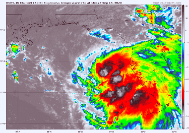
Ignoring the terrible quality of this gif, this is what a storm trying to wrap up convection and failing miserably looks like. Notice the black and white colors trying to shoot to the NW near the center then quickly fading back to red. That’s super tall storms that are getting knocked down (spread out as they try to wrap around) to lower levels of the atmosphere by the shear.
This post was edited on 9/13/20 at 3:13 pm
Posted on 9/13/20 at 3:09 pm to rds dc
quote:
The amount of rainfall probably isn't impacted too much by strength, so a stronger system might be preferred as the slow down and turn could be more over open water. Another possibility, the earlier turn results in more time over water and results in a stronger system?
Seems like a little bit of both uh? Makes sense a deeper storm would feel a little more of the north push, and also you see a stronger storm because it's over water longer.
Enough Euro members look stronger earlier and get to the MOTM where a few in that MS and Mobile cluster don't get green until it gets running north and has time over water.
Posted on 9/13/20 at 3:10 pm to GEAUXmedic
quote:
St. Martin
Hmm. Surprising to not see St Mary if they’re closing St Martin.

 Page 76 of 298

Popular
Back to top