




- My Forums
- Tiger Rant
- LSU Recruiting
- SEC Rant
- Saints Talk
- Pelicans Talk
- More Sports Board
- Fantasy Sports
- Golf Board
- Soccer Board
- O-T Lounge
- Tech Board
- Home/Garden Board
- Outdoor Board
- Health/Fitness Board
- Movie/TV Board
- Book Board
- Music Board
- Political Talk
- Money Talk
- Fark Board
- Gaming Board
- Travel Board
- Food/Drink Board
- Ticket Exchange
- TD Help Board
Customize My Forums- View All Forums
- Show Left Links
- Topic Sort Options
- Trending Topics
- Recent Topics
- Active Topics
Started By
Message
re: Old
Posted on 8/30/17 at 9:57 am to GEAUXmedic


Posted on 8/30/17 at 9:57 am to GEAUXmedic
quote:
@EdValleeWx 3h3 hours ago
More
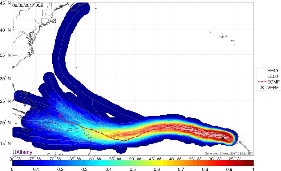
A developing area of high pressure in the Atlantic (forced by WPAC #Sanvu) will help force #93L westward next week toward US. A must-watch!
quote:
@JamesBelanger 3h3 hours ago
More
Probability of #93L tracking into the Gulf now up to 38% per latest calibrated #ECMWF ensembles. A more western track is now more likely.

 1
1

Posted on 8/30/17 at 10:03 am to rds dc

Things to watch, strength and that unusual SW turn.

Posted on 8/30/17 at 10:04 am to GEAUXmedic
All this shite makes my head hurt...

Posted on 8/30/17 at 10:07 am to rds dc
Riding under that big Atlantic ridge I assume for the projected SW trek.
Posted on 8/30/17 at 10:08 am to Cosmo
quote:
Models this far out are worthless
Dumb to stress over
Exactly. It's only recently that the general public is seeing long range models, so they don't realize that every week during Hurricane season, something is projecting some major landfall 500 hours out that never materializes.
If people ever looked at the long rage CMC (referred to as constantly making cyclones) they'd have a weekly heart attack.
Posted on 8/30/17 at 10:09 am to Duke
This is the thread we're using right?
Posted on 8/30/17 at 10:10 am to Cosmo
quote:
Models this far out are worthless
Dumb to stress over
No one is stressing, we're discussing.
Posted on 8/30/17 at 10:11 am to tLSU
It's currently a TS, so it's not your normal ignorable phantom model spin up. The steering is way too far out to have much faith in any path past the point she's north of the Antilles.
Posted on 8/30/17 at 10:12 am to GEAUXmedic
quote:
This is the thread we're using right?
Not sure, but probably for the best we stay here.
Our little post Harvey spin up can get a new thread when he forms up, as it isn't going to have the potential impacts of a long track CV storm in the heart of the season.
Posted on 8/30/17 at 10:15 am to Duke
True, we've already been discussing it enough here.

Posted on 8/30/17 at 10:35 am to GEAUXmedic
Cold front has to come through....

Posted on 8/30/17 at 10:36 am to GEAUXmedic
So the breakoff from Harvey is supposed to be somewhere on the gulf coast by sept 5th? Did I read that correctly?
Posted on 8/30/17 at 10:38 am to Ba Ba Boooey
quote:
So the breakoff from Harvey is supposed to be somewhere on the gulf coast by sept 5th? Did I read that correctly?
The new spin up in the gulf, yeah around that time... depending where it goes.
P.S. Harvey woke a lot of people up. Our first post on Irma crashed our site. That would never happen any other time for a storm that far away.
This post was edited on 8/30/17 at 10:39 am

Posted on 8/30/17 at 10:48 am to GEAUXmedic
quote:
Our first post on Irma crashed our site.
What's your site?
Posted on 8/30/17 at 10:50 am to SLafourche07
quote:
What's your site?
Stormcast
Posted on 8/30/17 at 11:04 am to rds dc
quote:
The models are going to struggle with 93L. Wave breaking across the North Atlantic is going to spin off some ULLs, not to different than what we saw during 92Ls trip across the Atlantic. Then there is a massive WPAC system that is going to pump a ton of energy into the high latitudes and that always gives the models fits. As that energy is distributed to the downstream waves it will determine the large scale setup across America and the Atlantic as 93L approaches. Stronger Eastern trough and weaker Atlantic ridge closes doors to the Gulf. The reverse certainly causes concern.
Before getting worked up about Irma remember that the models will struggle. However, climo tells us this system will have ample opportunities to curve out to sea.
Posted on 8/30/17 at 11:15 am to rds dc
quote:Well, that works for me.
However, climo tells us this system will have ample opportunities to curve out to sea.

Posted on 8/30/17 at 11:53 am to bobbyleewilliams
Many people seem to be confused.
They have a system in the gulf that they expect will hit us next week. Nothing strong just rain that is not needed. If I remember correctly this is what this thread started off talking about and switched to Irma.
In a completely separate issue is Irma.
They have a system in the gulf that they expect will hit us next week. Nothing strong just rain that is not needed. If I remember correctly this is what this thread started off talking about and switched to Irma.
In a completely separate issue is Irma.


Posted on 8/30/17 at 12:23 pm to rds dc
I can tell you right now, Irma is going to go right through the south tip of Florida sometime between Sept 10th - 12th. The stupid meeting planner at my company has almost 700 people flying in for our national sales meeting in Bonita Springs Sept 10 - 15.
There's a 40% chance every year of a cyclone event hitting somewhere in Florida on September 10th. It's the peak chance of it happening during hurricane season.

There's a 40% chance every year of a cyclone event hitting somewhere in Florida on September 10th. It's the peak chance of it happening during hurricane season.
quote:
"Hey! That means it's a 60% chance one won't hit Florida! Let's have our meeting there!"
Posted on 8/30/17 at 12:34 pm to rds dc
"Heading into early next week, both the GFS and the ECMWF indicate
that an inverted trough and possible weak low pressure system in
the Gulf of Mexico will move northward toward the forecast area.
The main impact from this trough axis will be a combination of
increased forcing aloft and deeper tropical moisture feeding back
into the area. A lack of any discernible synoptic scale low level
features to focus on implies that any convection forming next
Monday or Tuesday will tend to develop along pre-existing
mesoscale boundaries like seabreeze fronts. The convection will
tend to diurnally driven over land, and have highest POP values 40
to 50 percent in the afternoon hours each day. Expect to see
convective activity turn more isolated over inland areas in the
evening and overnight hours. However, along the immediate coast,
POP values could remain elevated at 30 to 40 percent through the
night as showers and storms offshore move in and dissipate.
Temperatures should remain near climatological averages early
next week."
that an inverted trough and possible weak low pressure system in
the Gulf of Mexico will move northward toward the forecast area.
The main impact from this trough axis will be a combination of
increased forcing aloft and deeper tropical moisture feeding back
into the area. A lack of any discernible synoptic scale low level
features to focus on implies that any convection forming next
Monday or Tuesday will tend to develop along pre-existing
mesoscale boundaries like seabreeze fronts. The convection will
tend to diurnally driven over land, and have highest POP values 40
to 50 percent in the afternoon hours each day. Expect to see
convective activity turn more isolated over inland areas in the
evening and overnight hours. However, along the immediate coast,
POP values could remain elevated at 30 to 40 percent through the
night as showers and storms offshore move in and dissipate.
Temperatures should remain near climatological averages early
next week."

 Page 9 of 10

Popular
Back to top
 Follow TigerDroppings for LSU Football News