- My Forums
- Tiger Rant
- LSU Recruiting
- SEC Rant
- Saints Talk
- Pelicans Talk
- More Sports Board
- Coaching Changes
- Fantasy Sports
- Golf Board
- Soccer Board
- O-T Lounge
- Tech Board
- Home/Garden Board
- Outdoor Board
- Health/Fitness Board
- Movie/TV Board
- Book Board
- Music Board
- Political Talk
- Money Talk
- Fark Board
- Gaming Board
- Travel Board
- Food/Drink Board
- Ticket Exchange
- TD Help Board
Customize My Forums- View All Forums
- Show Left Links
- Topic Sort Options
- Trending Topics
- Recent Topics
- Active Topics
Started By
Message
 3
3

Posted on 8/26/17 at 9:28 pm to Duke
4.2 inches per hour rates in Meyerland from KHOU TV.
Water may begin backing into homes.
Water may begin backing into homes.
quote:
Brays Bayou is a slow-moving river in Harris County, Texas. A major tributary of Buffalo Bayou, the Brays flows for 31 miles (50 km) from the western edge of the county, south of Barker Reservoir along the border with Fort Bend County, east to its convergence with the Buffalo at Harrisburg.[1] Nearly all of the river is located within the city of Houston; it is a defining geographic feature of many neighborhoods and districts, including Meyerland, Braeswood Place, the Texas Medical Center, and Riverside Terrace.
As a result of its central route through Harris County, the Brays Bayou watershed is heavily urbanized. Over 700,000 people reside within its 129-square-mile (330 km2) drainage area, which contains 124 miles (200 km) of open-channel waterway, mostly from artificial drainage channels.[1] This high level of development, combined with a relative lack of flood control infrastructure, means Brays Bayou is extremely prone to flash flooding events.
Posted on 8/26/17 at 9:28 pm to rds dc
quote:
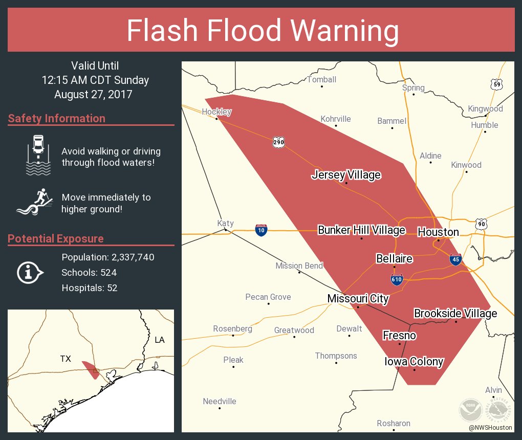
BULLETIN - EAS ACTIVATION REQUESTED Flash Flood Warning National Weather Service Houston/Galveston TX 927 PM CDT SAT AUG 26 2017 ...FLASH FLOOD EMERGENCY FOR West Central Harris, Eastern Fort Bend and Northern Brazoria counties...
This post was edited on 8/26/17 at 9:29 pm

Posted on 8/26/17 at 9:28 pm to noonan
quote:
Weather has been calm all day, but it's starting to get ugly out there.
Yep. Atascocita area here. Getting the flashlights out and enjoying the AC and TV while we have it.

Posted on 8/26/17 at 9:32 pm to Duke
quote:
slackster
Duke
Thanks for the insightful answer to my question above.
Posted on 8/26/17 at 9:32 pm to rds dc
They are telling people to raise things up as high as they can in their house but to stay in house because roads are flooding.
Damn.
Damn.

Posted on 8/26/17 at 9:34 pm to NorthEndZone
Man that last band was no joke. We got pasted in Cypress. It's still coming down at a good rate but it was nearly comical how bad it was raining.
Posted on 8/26/17 at 9:34 pm to NorthEndZone
quote:
Flash Flood Emergency: 3 to 4 inches have fallen over Harris/Fort Bend/Brazoria region over the last hour.
quote:
Flash Flood Emergency is out for S and SW Houston in Harris County, parts of E Fort Bend County, and NW Brazoria county until 12:15AM.
Posted on 8/26/17 at 9:35 pm to NorthEndZone
quote:
They are telling people to raise things up as high as they can in their house but to stay in house because roads are flooding.
Damn.
That might be the most disturbing thing I have read through all of this.
Posted on 8/26/17 at 9:36 pm to rds dc
quote:
Flash Flood Emergency coming for Houston.
This is only the 2nd ever Flash Flood Emergency issued for Houston.
Posted on 8/26/17 at 9:39 pm to slackster
You see that orange stuff to the northwest on the radar? That's dry air, and will end this sucker unless it outruns it heading eastward or once again enters the gulf.
I think tonight is the worst of it.
I think tonight is the worst of it.
Posted on 8/26/17 at 9:42 pm to Jobu93
Doesn't appear there will be the same gap between band as there was earlier today in Houston, but it will be relief for now nonetheless.

Posted on 8/26/17 at 9:44 pm to LSUgusto
quote:
You see that orange stuff to the northwest on the radar? That's dry air, and will end this sucker unless it outruns it heading eastward or once again enters the gulf.
I think tonight is the worst of it.
You should pass this insight along to the NWS.
Posted on 8/26/17 at 9:44 pm to LSUGrad9295

Posted on 8/26/17 at 9:46 pm to LSUgusto
quote:
That's dry air, and will end this sucker unless it outruns it heading eastward or once again enters the gulf.
No it won't. Right idea if we've got a developing cyclone.
The low has to go away or go east of Texas coast for the pull off the gulf to cease. It's just going to pull water off the gulf, it'll lift over Texas coast and rain and rain.
Eventually I'll pull toward the dry air and stop, but that pocket of dry air isn't going to overrun this thing.
Posted on 8/26/17 at 9:46 pm to slackster
Is it just me, or do they put the most random towns on these NWS graphics sometimes?
Posted on 8/26/17 at 9:47 pm to slackster
Mark my words. Been watching storms for a long time. That big red mass of dry air is a killer for these types of storms. Be glad about that.
Posted on 8/26/17 at 9:52 pm to RummelTiger
Keep an eye on the area in the white circle, if cells start to fire in there to fill it in, that would be really bad.

Posted on 8/26/17 at 9:52 pm to LSUgusto
quote:
Mark my words. Been watching storms for a long time. That big red mass of dry air is a killer for these types of storms. Be glad about that.
I'd love for you to be right, but you aren't. As Duke said, dry air is a problem for a storm at sea trying to strengthen. A stalled low pressure system over Cuero, TX, doesn't have to worry about dry air when it is raining on Galveston.
Posted on 8/26/17 at 9:54 pm to rds dc
quote:
Keep an eye on the area in the white circle, if cells start to fire in there to fill it in, that would be really bad.
I've been watching that same area myself. The current band that is going through didn't look all that impressive when it started, but it matured very quickly.

 Page 25 of 38

Popular
Back to top