- My Forums
- Tiger Rant
- LSU Recruiting
- SEC Rant
- Saints Talk
- Pelicans Talk
- More Sports Board
- Fantasy Sports
- Golf Board
- Soccer Board
- O-T Lounge
- Tech Board
- Home/Garden Board
- Outdoor Board
- Health/Fitness Board
- Movie/TV Board
- Book Board
- Music Board
- Political Talk
- Money Talk
- Fark Board
- Gaming Board
- Travel Board
- Food/Drink Board
- Ticket Exchange
- TD Help Board
Customize My Forums- View All Forums
- Show Left Links
- Topic Sort Options
- Trending Topics
- Recent Topics
- Active Topics
Started By
Message
re: Morganza Spillway may or may not open for a 3rd time -- lack of clear info from ACoE
Posted on 5/24/19 at 12:49 pm to slackster

Posted on 5/24/19 at 12:49 pm to slackster
quote:
The river is already 3 feet lower in northern Mississippi than the crest, so it's got room for more rain.
I know you know a whole lot more than me so I respect your opinions on things like this but wouldn't the fact that the river bed is obviously higher now than in recent years mean it would still rise around here?
 3
3

Posted on 5/24/19 at 1:07 pm to TDsngumbo
quote:
As the Corps of Engineers conducts daily inspections of the levees below Chalmette some residents are growing increasingly concerned about a number of seepage points where water appears to be oozing through saturated levees. The corps says everything is OK but they remain watchful. They are preparing to open the Morganza spillway but say the impacts of that will be felt more in Baton Rouge then it will in New Orleans


Posted on 5/24/19 at 1:12 pm to Nado Jenkins83
quote:
It will be an improvement to BR
Are you aware that Morganza is on the west side and BR on the east?
Posted on 5/24/19 at 1:19 pm to tgrbaitn08
That's the video I was referring to. Sounds like that river is about to seriously push some water in the next week.

Posted on 5/24/19 at 1:21 pm to TDsngumbo
He’s saying that the upstream portion of note has already gone down some while downstream it’s still high, comparably.
Posted on 5/24/19 at 1:49 pm to tgrbaitn08
All that water thats already on the ground headed this way with addition to anything thats forecasted to fall over the next week in the midwest paints a scary picture beyond what local press releases give
Posted on 5/24/19 at 1:52 pm to FelicianaTigerfan
quote:
All that water thats already on the ground headed this way with addition to anything thats forecasted to fall over the next week in the midwest paints a scary picture beyond what local press releases give
Just gotta trust the officials know what they're talking about. I have to believe with all the litigation and criticism being thrown around these days that if they see a legitimate threat of catastrophe, they'd sound the alarms.
Just wait and see for now. If you live in the Morganza floodway then I would probably have my things packed and ready to go along with a place picked out to evacuate to by now. Just in case.

Posted on 5/24/19 at 1:59 pm to TDsngumbo
I keep thinking about Morgana the Kissing Bandit when I see the title.. I'm old.

Posted on 5/24/19 at 1:59 pm to TDsngumbo
quote:
wouldn't the fact that the river bed is obviously higher now than in recent years mean it would still rise around here?
It's a material balance. While the higher riverbed means lower flows generate higher levels, if less overall water is coming in vs leaving, the river will drop.
Posted on 5/24/19 at 2:10 pm to FelicianaTigerfan
quote:
All that water thats already on the ground headed this way with addition to anything thats forecasted to fall over the next week in the midwest paints a scary picture beyond what local press releases give
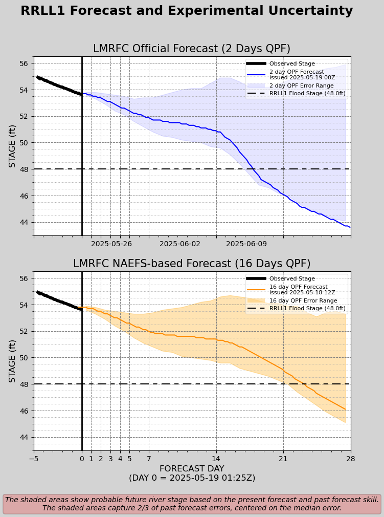
FWIW, they're doing a trial using 16 day precip forecasts vs 2 day and it paints the current forecasts as pretty reasonable. The error on the 2 day looks scary, but the 16 day error has the forecast riding near the middle of the spread.
Still some high side risks present but we're getting into the summer pattern now. The parade of mid lat lows will slow down as the jet stream stops dipping as far south. Still will see a wet pattern over the midwest for the next few weeks I suspect but it's going to shift father north over time. Giving us time to get the current Arkansas River water time to get to the gulf.
Posted on 5/24/19 at 2:26 pm to Duke
The flat line at 62.1 is suspiciously flat...wonder why that is?

Posted on 5/24/19 at 2:42 pm to FutureMikeVIII
quote:
The flat line at 62.1 is suspiciously flat...wonder why that is?
Red River Landing is upstream of the Morganza.
It's because it takes a lot of additional water to raise the river level just a little bit when it's this spread out.
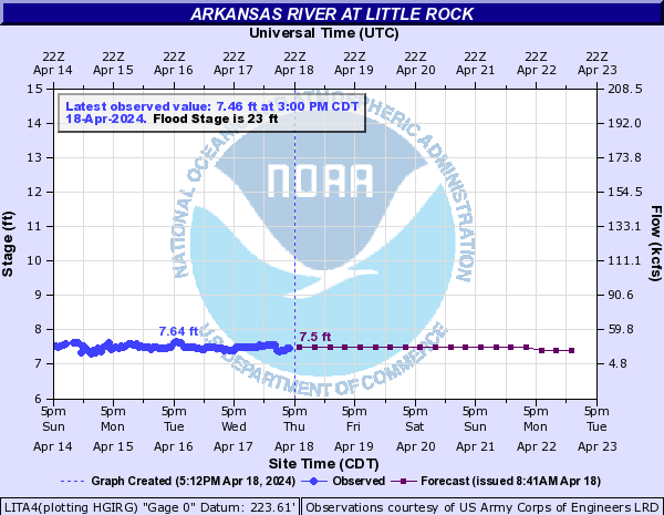
Look at the flow rates on the Arkansas River, for example, as the flood stage rises.
Posted on 5/24/19 at 4:09 pm to Duke
Cool video I'd recommend everyone in this thread watch. Thankful for the subtitles lol.
https://biggerpieforum.org/environment/ms-river-in-danger-of-being-captured-by-the-atchafalaya-river/
quote:
Dr. Y. Jun Xu, world-renowned hydrologist of Louisiana State University, explains how South Louisiana is on the verge of one of the worlds most detrimental natural disasters in history.
https://biggerpieforum.org/environment/ms-river-in-danger-of-being-captured-by-the-atchafalaya-river/
Posted on 5/24/19 at 4:13 pm to WizardSleeve
Like he mentioned, if a break ever occurred at ORCS, the percentage of flow would jump up very rapidly down the Atchafalaya, think 40-50% instead of the current 30%.

Posted on 5/24/19 at 4:18 pm to jimbeam
If a break occurred at ORCS it would frick shite up but once the river went to low levels in the fall they could dam it up and repair it just like how they built ORCS in the first place. People act like a break would happen and we’d just say frick it.
This post was edited on 5/24/19 at 4:20 pm
Posted on 5/24/19 at 4:20 pm to The Boat
They would certainly make every attempt, but they would just be likely dealing with more water flowing through there than currently allowed.
Problem is, this issue will never go away. The MS will never stop depositing sediment where ever the hell it wants.
Problem is, this issue will never go away. The MS will never stop depositing sediment where ever the hell it wants.
This post was edited on 5/24/19 at 4:25 pm
Posted on 5/24/19 at 4:22 pm to The Boat
quote:
in the fall they could dam it up and repair it just like how they built ORCS in the first place
This post was edited on 5/24/19 at 4:23 pm
Posted on 5/24/19 at 4:22 pm to Duke
RRL is close enough for the operation of the spill way to affect water levels.
Natchez is also upstream of Morganza, but it still shows the typical hydrograph peak that you’d expect.
Pretty sure that flat line is artificial due to the operation of Morganza.
Natchez is also upstream of Morganza, but it still shows the typical hydrograph peak that you’d expect.
Pretty sure that flat line is artificial due to the operation of Morganza.
Posted on 5/24/19 at 4:23 pm to The Boat
quote:
If a break occurred at ORCS it would frick shite up but once the river went to low levels in the fall they could dam it up and repair it just like how they built ORCS in the first place. People act like a break would happen and we’d just say frick it.


 Page 66 of 107

Back to top